19/09/2024-25/09/2024
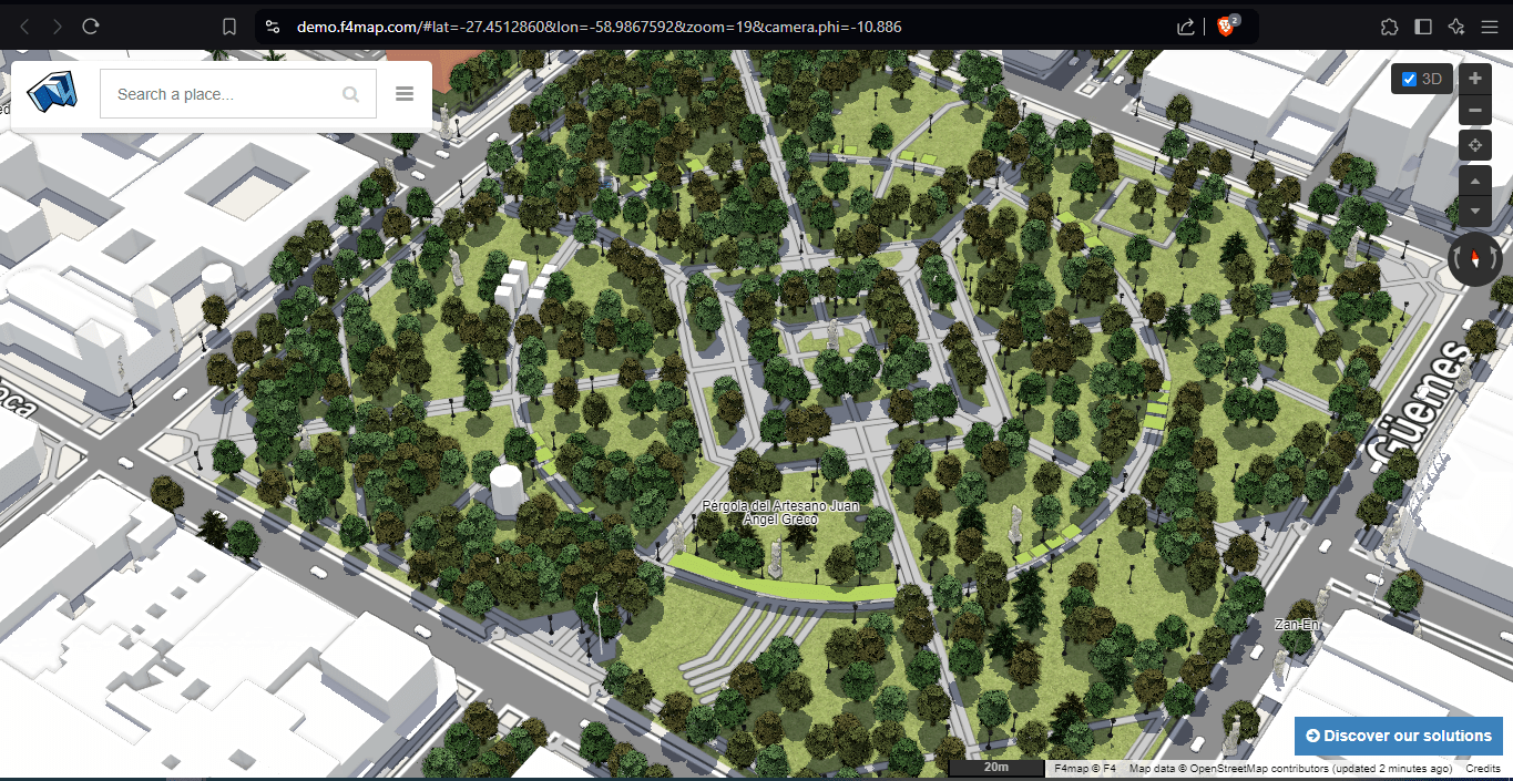
The Plaza 25 de Mayo de 1810 in Resistencia, Argentina [1] | © F4map | Map data © OpenStreetMap contributors
Mapping campaigns
- The Trufi Association reported about their project to fully map the Zamora (Mexico) public transport system
in collaboration with Codeando México and with the support of HOT. They observed that the project revealed fewer routes and vehicles than expected, leading to better informed urban mobility planning. - Yulia Fedorova presented
 ►
► the Missing Maps project, in collaboration with HOT, along with a mini-guide on how to join in with volunteer mapping. Tools such as the Tasking Manager were also presented.
Community
- Ezra Edwards blogged about the first mapathon in Pakistan. The collaborative event took place in Islamabad, Karachi, and online.
- Jennifer made
 an embroidered OpenStreetMap logo using the InkStitch plugin for Inkscape, an open-source machine embroidery design platform.
 - Kajord spent 11 nights backpacking in Glacier National Park (U.S.A.) and mapped the area around the Hole-in-the-Wall Camp.
- CycleStreets has proposed a complete overhaul of the Bicycle page on the OSM wiki. The work is already underway, with several gaps being addressed, and feedback via the OSM Community forum is welcome.
Imports
- Tallcoleman shared some lessons learned from the completion of the Toronto public toilet import project.
Events
- Jennifer shared ► a report from FOSSGIS e.V. and the local OSM group’s participation in the 22nd Kiel Open Source and Linux Days. They presented a talk titled ‘20 Years of OpenStreetMap‘ and managed the OSM stand, which featured tactile maps, maps with surveillance cameras, and a game where visitors could complete a map of Kiel that had been stripped of its labels.
- The IVIDES.org hosted a seminar in support of Rio Grande do Sul, Brazil, with the participation of scientists who acted during the critical phase of the disaster (we reported earlier). Special keynotes included a systems approach to environmental planning, collaborative mapping, free software and open data in disaster risk reduction, and critical geography. Raquel Dezidério commented
 ► about the event in her diary.
 ►
►OSM research
- Bobby Xiong et al. modelled the European high-voltage grid based on OpenStreetMap data.
- HeiGIT reported that they have conducted a data quality assessment of open source data (including OSM) using their ohsome quality API. They analyzed aspects such as currentness, completeness, comparison with external datasets, and the activity of OSM contributors. The results of the analysis were to support the efforts of the World Bank to develop an analytical tool, the Gender Enabling Environments Spatial Tool, designed to assess localities based on how supportive they are in enabling women to access employment or business opportunities in the renewable energy sector.
OSM in action
- Jordi Gauchía has developed IceNav, an ESP32-based satellite navigator device using OSM offline maps.
- The Ostsee-Zeitung newspaper has utilised ► an OpenStreetMap-based map to display the locations of flea markets in Mecklenburg-Vorpommern, Germany.
- Transitous is a community-run, provider-neutral international public transport routing service. It uses the MOTIS routing engine, which utilises the OpenStreetMap basemap. You can check out the live demo at MOTIS.
- Jiří Eischmann observed ► that Czech state organisations extensively used OpenStreetMap to assist with the recent flood disaster, including for flood services, radar maps, and flood risk maps.
- Auto Motor und Sport is a German automotive publication that focuses on delivering news, reviews, and insights into the automotive industry. In one of their articles, they used ► an OSM-based map as an illustration.
- The volunteer project Companionaid, for women’s safety, has launched a map of (un)safe places in Russian cities, from which women can collect information about dangerous places in cities. An OSM-based map is used as the background.
 ►
►Licenses
- The Fédé des pros d’OSM (OSM Pros’ Federation) announced the publication of their practical guide Tout Savoir
Sur La Licence ODbL (All about ODbL Licensing).
 the publication of their practical guide Tout Savoir
Software
- Rudo Kemper has created a webpage to convert Google Maps GeoJSON data into GPX and KMZ files, allowing them to render properly in Organic Maps.
Releases
- Sarah Hoffmann announced the release of version 4 of pyosmium, a Python wrapper for the Osmium C++ library, used for reading, writing, and processing OSM data. This major update includes several new features, such as iterative processing, filter functions, and an OSM data writer with automatic reference completion.
- Eugene Kizevich announced the release of OsmAnd Web Version 1.01. You can explore the latest version directly at OsmAnd Map.
- osm2pgsql version 2.0.0 has been released.
Did you know …
- … that you can geolocate an image by comparing the height of an object with the length of its shadow?
- …that there is an in-depth course on validating OSM data on the UN Maps Learning Hub? It has been available since the beginning of the year and was used for a 20-hour training course organised over several weeks, followed by weeks in which participants applied their new knowledge. To access it, you will need to create an account on the Moodle platform used by the UN Maps Learning Hub.
OSM in the media
- [1] Diario Norte, a online news outlet based in Argentina, reported ► that Federico Pértile mapped 629 trees (while also identifying the species of each one), 324 streetlights, 268 benches, and 74 trash bins around the Plaza 25 de Mayo de 1810 in Resistencia City, Argentina, on OpenStreetMap and then shared a 3D map visualisation of the area.
- OpenStreetMap data powered The Washington Post’s story about the size and territory of supermarket chains in the US.
 ►
►Other “geo” things
- Julia Fritzsche has directed a documentary The Answer to Almost Everything: How Powerful Are Maps? It discusses the political aspects of map-making, from a historical perspective to some practices that still exist today.
- Matthew Daniels has collected all the outdoor basketball courts in the United States based on OpenStreetMap and Google satellite imagery. The site also has the option to leave comments and likes on these courts and group them by colour.
- Michael Tandy explained the complexity of address data in ‘Falsehoods Programmers Believe About Addresses’, their 2013 classic on the subject.
- Wildfires in Peru have reached critical levels, severely affecting ► the flora and fauna in various regions of the country. In response, CONIDA, the Peruvian space agency, has intensified its satellite monitoring ►, providing authorities with accurate and timely data. This information is crucial for making quick and effective decisions based on the scale of the disaster.
- The Tokyo Cartographic Co., Ltd and MIERUNE Ltd have released ► ‘Mamore! Saigai Boueitai’ (守れ!サイガイ防衛隊 / Protect! Disaster Defense Squad), a map-themed educational game about disaster prevention.
 ►
►Upcoming Events
| Where | What | Online | When | Country |
|---|---|---|---|---|
| Marpingen | Craft Mapping an der “Marpinger Grenzstein-Tour” | 2024-09-29 |  | |
| Defence Colony Tehsil | 12th OSM Delhi Mapping Party | 2024-09-29 |  | |
| City of Edinburgh | Geomob Edinburgh | 2024-10-01 |  | |
| Salzburg | OSM Treffen Salzburg | 2024-10-01 |  | |
| San Jose | South Bay Map Night | ✓ | 2024-10-02 |  |
| Missing Maps London: (Online) Mapathon [eng] | 2024-10-01 | |||
| Stuttgart | Stuttgarter OpenStreetMap-Treffen | 2024-10-02 | | |
| Essen | FOSSGIS-OSM-Communitytreffen Nr. 22 | 2024-10-03 – 2024-10-06 | | |
| Montrouge | Réunion des contributeurs de Montrouge et du Sud de Paris | 2024-10-03 |  | |
| Pontarlier | Cartographie collaborative pour tous | 2024-10-05 | | |
| Chanakya Puri Tehsil | OSM India casual online mapathon | 2024-10-06 | | |
| London | London pub meet-up | 2024-10-07 | | |
| 中正區 | OpenStreetMap x Wikidata Taipei #69 | 2024-10-07 |  | |
| München | Münchner OSM-Treffen | 2024-10-08 | | |
| Ifẹ̀ | State of the Map Nigeria 2024 | 2024-10-09 – 2024-10-11 |  | |
| Lorain County | OpenStreetMap Midwest Meetup | ✓ | 2024-10-10 | |
| Bochum | Bochumer OSM Treffen | 2024-10-10 | | |
| OSMF Engineering Working Group meeting | 2024-10-11 |
Note:
If you like to see your event here, please put it into the OSM calendar. Only data which is there, will appear in weeklyOSM.
This weeklyOSM was produced by MatthiasMatthias, PierZen, SeverinGeo, Strubbl, TheSwavu, TrickyFoxy, barefootstache, derFred, mcliquid, rtnf.
We welcome link suggestions for the next issue via this form and look forward to your contributions.