03/08/2016-03/14/2016
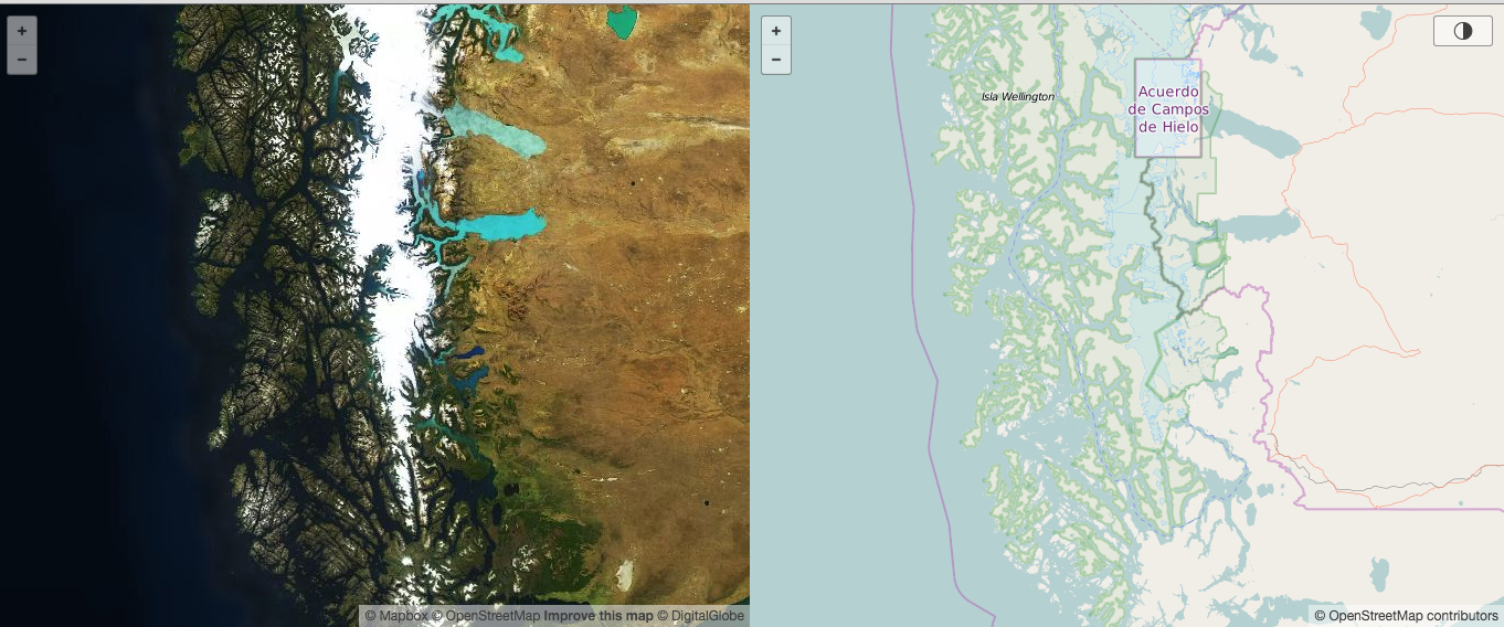 A direct map comparison between the standard OSM layer and Mapbox satellite [1]
About us
- Our Upcoming Events are parsed automatically from the Wiki Calendar by OSMBC. You can support the team by verifying your event entry in the public preview and check your entry with the regex tester.
Mapping
- Bernhard W. has obtained oblique (or slant) aerial photographs of the city of Mannheim and he is asking on the German OSM forum about possible ways to use them in JOSM.
- [1] Try a direct map comparison between the standard OSM layer and Mapbox satellite images by Alex Barth.
- There was a discussion (in German) about strange translations in the iD editor.
- User SM@Edit writes about his experience in mapping with OpenStreetMap. He also has written diaries on mapping Sidewalks in Kottayam City and mapping a 15+ km long canal and grasslands.
- The web service fieldpapers.org has got a polished user interface for printing OSM based maps.
- With Spring break upon us, Mapzen writes about helping fellow travel-resolution enthusiasts by adding hotels and other types of lodging to OpenStreetMap.
- User baditaflorin writes about a PostGIS script which can help find duplicated nodes in an area.
- International Women’s Day was celebrated in different ways, including pledging for parity, encouraging learning and mapping with respect to female related POIs and tags.
- SK53 shares his thoughts about how the same amenity ‘pub’ is mapped as an area as well as a point. Neither of them are wrong but he asserts that it would be a good thing to find a consistent style which satisfies most needs.
Community
- Commodoortje wonders whether it is appropriate to do indoor mapping of a house.
- Joost Schouppe explores a few methods to find paved and unpaved roads in South America
- In his series “Mapper in the Spotlight” user escada conducted an interview with Nick from the Netherlands.
- SHTOSM (The Russian OSM News blog) reports about the mapping effort to put Grozny “on the map” (in Russian)
- A video tutorial explaining how to use OpenStreetMap data in QGIS.
Imports
- The metropolian area Rhineland in Germany (Cologne, Bonn, Düsseldorf) started a project Effiziente und stadtverträgliche Lkw-Navigation (efficient and city-reconcilable truck navigation) and wants to map the so called “Lkw-Vorrangrouten” (truck preference routes) into OSM. These routes have been created by the city governments of this area. As part of this project, Dominik Paaß asks some questions regarding how this may be carried out with respect to OSM on the Talk-de mailing list and initiates a large discussion.
Events
- An international conference on free software is being hosted in Havana, Cuba on the 25th-27th of April 2016, sponsored by Mapbox.
- State of the Map Japan will take place on the 6th of August in Tokyo.
- The dzone blog writes about how citizens of a city in Nicaragua helped map the best routes in the city to improve public transportation.
- Fundación Ciudadano Inteligente (Smart Citizen Foundation) celebrated Open Data Day Santiago: under the theme “Bringing an ‘Open’ Philosophy to the people”
- Bestford Guri invites the OSM community to the “Open Source Conference Albania”, a conference in Tirana (Albania) on the 14th and 15th of May.
- Iván Sánchez Ortega will be giving a talk about Leaflet at the event the future of leaflet, one of the most widely used web mapping frameworks. Ivan will talk about the library, with the imminent release of version 1.0 and some ideas for the future.
Humanitarian OSM
- On Thursday, March 3rd 2016, a world-record humanitarian mapathon took place at Politecnico di Milano in northern Italy. Two-hundred and twelve 10-year old children from nine classes at six elementary schools in Milan province got together and mapped Swaziland to help eradicate malaria in the country.
- The blog writes about how humanitarian open source mapping can make a big difference in emergencies, since detailed maps can help to deliver aid where needed.
Maps
- A video tutorial shows the rendering options available in Oruxmap.
- A virtual walk with smartphone through historic Berlin. The app features OSM as a comparison layer to the historic maps.
switch2OSM
- Bahnhof.de (German Bahnhof = train station), a website of Deutsche Bahn, offering information for passengers, switched to OSM (example).
Open Data
- Kathmandu Living Labs celebrated the first Open Data Day 2016 in Pokhara, Nepal.
Licences
- A German journalist has to pay €1700 after receiving a cease and desist letter in 2012 for making a screenshot of an oblique aerial image of Bing Maps for comparison of old and new image material. The complainant was not from Microsoft but a company that created the images in the first place. (automatic translation)
Software
- An article about how to build your own offline OSMAND maps using completely free tools.
Programming
- Jochen explains his renumbering command in osmium-tool to store ID numbers of OSM elements with less space needed than original OSM numbering.
- Traccar, a tool used for reverse geocoding.
Releases
| Software | Version | Release Date | Comment |
|---|---|---|---|
| Level0 | 1.2 | 2016-02-09 | Low level browser based editor |
| Routino | 3.1.1 | 2016-03-06 | Many changes and bug fixes of version 3.0 |
| Mapillary for Android | 1.7.9 | 2016-03-10 | Mapbox version 3.2.0, rudimentary Google Analytics |
| Mapillary for iOS | 4.1.6 | 2016-03-11 | Improvements and fixes for the cameras |
| JOSM | 9979 | 2016-03-12 | Bug fixes, mainly the OAuth problem |
| OpenJUMP | 1.9.1 | 2016-03-13 | New features and bug fixes |
provided by the OSM Software Watchlist
Did you know …
- OSM Flyers and posters…
Other “geo” things
- A map showing the importance of tlds.
- A monumental sculpture of the ‘blue Planet‘ in the ‘Gasometer Oberhausen’.
- Mashable reports on an Irish startup called Access Earth which “wants to be a Google Maps for people with disabilities”. It is like Wheelmap but commercial and uses OSM data only for the background map. Therefore it has nearly no content (Wheelmap is six years older).
- A kickstarter project on Vector maps for everyone.
- Facebook is building it’s own maps using artificial intelligence.
- The JavaScript based leaflet can also display things other than maps, for example the mainboard of the project Everykey.
- The University of California – Riverside created a new method to solve the integer ambiguity when using phase shift GPS positioning. This allows for millimetre accuracy with low power consumption.
- Google has renamed Skybox to Terra Bella. Skybox was bought by Google in 2014 and operates earth observation satellites. Terra Bella will extend its business activity on analysis of satellite imagery.
Upcoming Events
| Where | Event | Date | Country |
|---|---|---|---|
| Georgetown | Open Data/ OSM Mapping Party | 11/03/2016 |  |
| Chemnitz | Chemnitzer Linux-Tage 2016 | 19/03/2016-20/03/2016 |  |
| Akihabara | 第2回秋葉原マッピングパーティー | 20/03/2016 |  |
| Bonn | FOSS4G 2016 Call for Submissions ends 21St of March | 21/03/2016 | |
| Nottingham | Nottingham | 22/03/2016 |  |
| Antwerp | Missing Maps Mapathon | 23/03/2016 |  |
| Rennes | Rencontres mensuelles | 23/03/2016 |  |
| San Francisco | AAG Mapathon | 31/03/2016-01/04/2016 |  |
| Bordeaux | Missing Maps mapathon | 31/03/2016 | |
| Sankt Gallen | Mapping Party following AGM | 02/04/2016 |  |
| Sankt Gallen | 2016 SOSM Annual General Meeting | 02/04/2016 | |
| Buenos Aires | FOSS4G Argentina | 05/04/2016-09/04/2016 |  |
| Berlin | Hack Weekend | 30/04/2016-01/05/2016 | |
| Clermont-Ferrand | State of the Map France 2016 | 20/05/2016-22/05/2016 | |
| Brno | State of the Map CZ+SK 2016 | 21/05/2016 |  |
| Edinburgh | Edinburgh | 14/06/2016 |  |
| Salzburg | FOSSGIS 2016 | 04/07/2016-06/07/2016 |  |
| Salzburg | AGIT 2016 | 06/07/2016-08/07/2016 | |
| Seattle | State of The Map US 2016 | 23/07/2016-25/07/2016 | |
| Tokio | State of The Map Japan 2016 | 06/08/2016 | |
| Bonn | FOSS4G 2016 Code Sprint | 20/08/2016-22/08/2016 | |
| Bonn | Workshops at FOSS4G 2016 | 22/08/2016-23/08/2016 | |
| Bonn | FOSS4G 2016 | 24/08/2016-26/08/2016 | |
| Bonn | FOSS4G 2016 Code Sprint Part II | 27/08/2016-28/08/2016 | |
| Brussels | State of the Map 2016 | 23/09/2016-26/09/2016 | |
Note: If you like to see your event here, please put it into the calendar. Only data which is there, will appear in weeklyOSM. Please check your event in our public calendar preview and correct it, where appropiate..
This weekly was produced by Laura Barroso, Nakaner, Peda, Rogehm, derFred, escada, jinalfoflia, mgehling, seumas, stephan75, wambacher, widedangel.