11/07/2017-17/07/2017
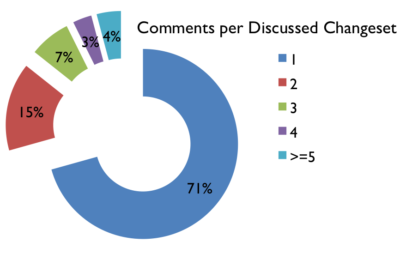
Pascal’s evaluation of the number of comments per changeset indicates many monologues 1 | Image by Pascal Neis under CC-BY-SA 3.0
Mapping
- Nicolas Toublanc has a nice culinary question on how to map “Oyster farmers: growers, sellers, oyster bar and seafood” and a quick answer by Vincent Bergeot.

- Svavar Kjarrval wrote about several issues in the development of a router for pedestrians. He seeks solutions, including one to differentiate routing , whether a road can be crossed anywhere or must be crossed only on crosswalks.
- Horea Meleg of TeleNav asks at the Talk-US mailing list for the good practice on how to map lanes, turn lanes and signposts
- ChristianA shares in his user diary how he mapped some old and unused quarries near his home.
- Earlier we reported about Daniel’s work related to identifying potential sharp turns onto ramps. Following some discussions, they have refined some checks and added new ones for sharp turns (e.g. sharp turns from one ramp onto another). Here are the up-to-date results for the planet.
- Kathmandu Living Labs (KLL) has started “project Ilam” together with Marek Kleciak, Heinz_V and WojtekK. The main goal is to get the utmost possible data accuracy using new high resolution imagery from Bing and Digital Globe in the district of Ilam, Nepal. The wiki page of this project describes how to identify such areas from aerial images. The project should demonstrate to the authorities in developing countries the usefulness of OpenStreetMap. The area should act as test area for comparing armchair mapping data to the reality in the field and support governments and NGOs. The project is looking for experienced mappers: sorry, no newcomers.
- User taz2015 asks at the English OSM Forum how to handle erroneous data from the TIGER import.
- Mapbox has purchased satellite imagery of 8.2 million square kilometers. Camilla Mahon explained in Mapbox’s blog how it decides which areas require better pictures.

Community
- OpenCage data, the blog of Open Cage Geocoder published an interview with Hernán aka Hernan and Zalitoar in which they speak about the state of OSM and its community in Argentina – their current work and future plans.
- Who is commenting? An Overview about OSM Changeset Discussions, a new blog post by Pascal Neis.
Events
- In a month, the State of the Map 2017 conference starts in Aizu-Wakamatsu, Japan.
- This year marks the OSM’s 13th birthday which is celebrated on August 13th. Don’t forget to enter your local events to the OSM wiki.
- On July 21st a mini conference takes place on bike data (open data) organized by the Open Knowledge Foundation Belgium in Brussels.
- On July 15th, Marek Strassenburg-Kleciak was elected as chairman of OSM Poland in Łodź, Poland. For all other functions, refer to the website.
- On Tuesday, July 19th, Rubén López of Mapbox made a presentation for 60 students at the Congress of Information and Communication Technologies in Churcampa – Huancavelica. Rubén spoke about OpenStreetMap, how to collaborate with the OpenStreetMap community, how to add data to the map and the different applications that can be done using OpenStreetMap data.
Humanitarian OSM
- John Whelan notes on the HOT mailing list that there is a large number of untagged ways in Chad. Many of them are buildings, but not all.
Education
- Mario asked in the gvSIG blog: “Have you decided to learn to work with a Geographic Information System and you don’t know how to start?” His answer to this question is a free book with the title, “Learning GIS with Game of Thrones“.
Maps
- With the help of Leaflet and OverpassAPI, Harald Hartmann made a nice visualization of view points with views towards.
Open Data
- The Ordnance Survey in England has released a large set of data with various green spaces in England as open data. It is not yet clear whether the data are compatible with OSM.
Software
- NextGIS announced OSMInfo, a new tool for using OSM data in QGIS.
- The MapOSMatic fork of Hartmut now supports Email notifications once your requested map is ready or an error occurred. In addition, his instance also offers the map styles Pencil, Space Station and Blossom.
Programming
- Daniel Koć searches a server to work on the middle zoom levels of OSM Carto for some weeks.
- Andy Allan started work on the preparation of the integration of the moderation branch, a former GSoC project, into the OpenStreetMap website and API. The branch adds a report button. Up to now users have to report spam via email or IRC.
Releases
- Tobias Zwick has officially released StreetComplete. It can be downloaded at FDroid or in the PlayStore.
- The new release of Mapbox Directions swift comes with added
attribute optionsoption,congestion, for obtaining the level of traffic congestion along each segment of a RouteLeg and much more - Mapbox’s new release for the Navigation iOS comes with a style specifically designed for turn-by-turn navigation, with French, Hungarian, Lithuanian, Persian, and Spanish localizations and much more.
- Other releases
- Jungle Bus 1.2 | 11.07.2017
- Komoot Android 9.3 | 13.07.2017
- Kurviger Free 1.1.5 | 13.07.2017
- Mapillary Android 3.67 | 11.07.2017
- OSM Contributor 3.0.5 | 12.07.2017
Did you know …
- The uMap map of all world-wide host cities of the State of the Map (SotM) and FOSSGIS events
Other “geo” things
- An animation of ThingsWork shows the course of a day for winter and summer solstice.
- ThingsWork shows the change of the Ucayali river from 1985 to 2013.
- Boundless, an US open-source GIS company, announces a “strategic partnership” with Mapbox. In a press release they say that their customers will receive easier access to Mapbox products.
- Mapzen now offers map matching, which “takes in a trajectory of latitude/longitude coordinates and returns back a route line that is snapped to the OpenStreetMap road network and enriched with attributes, like speed limits and freeway exit signs.”
- ORF reported about a study of the University of Stanford, how much people are walking in different countries on daily-basis.
- Antonio Zugaldia from Mapbox shows how to generate traffic maps and add images in Alexa Show skill using Mapbox Java Services.
Upcoming Events
| Where | What | When | Country |
|---|---|---|---|
| Seattle | Complete The Map Challenge, Mapillary image mapping | 2017-06-23-2017-07-31 |  |
| Bremen | Bremer Mappertreffen | 2017-07-24 |  |
| Graz | Stammtisch Graz | 2017-07-24 |  |
| Nottingham | Nottingham Pub Meetup | 2017-07-25 |  |
| Viersen | OSM Stammtisch Viersen | 2017-07-25 | |
| Dusseldorf | Stammtisch Düsseldorf | 2017-07-26 | |
| Itami | 【西国街道#08】オープンデータソンin伊丹「有岡城惣構」 | 2017-07-29 |  |
| Tokyo | 東京!街歩かない!マッピングバーティ2 | 2017-07-29 | |
| Managua | Editathon with iD | 2017-07-29 |  |
| Taipei | OpenStreetMap Taipei Meetup, MozSpace | 2017-07-31 |  |
| Rostock | Rostocker Treffen | 2017-08-01 | |
| Stuttgart | Stuttgarter Stammtisch | 2017-08-02 | |
| Brisbane | Nundah Mapping Party | 2017-08-04 |  |
| Amagasaki | 地図好きに送るオープンストリートマップの使い方 in みんなのサマーセミナー2017 | 2017-08-05 | |
| Taipei | COSCUP OpenStreetMap Track, National Taiwan University Social Science College | 2017-08-05 | |
| Kusatsu | 真夏のマッピングパーティ in 草津 | 2017-08-06 | |
| Boston | FOSS4G 2017 | 2017-08-14-2017-08-19 | |
| Aizu-wakamatsu Shi | State of the Map 2017 (international conference) | 2017-08-18-2017-08-20 | |
| Patan | State of the Map Asia 2017 | 2017-09-23-2017-09-24 |  |
| Boulder | State of the Map U.S. 2017 | 2017-10-19-2017-10-22 | |
| Buenos Aires | FOSS4G+State of the Map Argentina 2017 | 2017-10-23-2017-10-28 |  |
| Brussels | FOSS4G Belgium 2017 | 2017-10-26 |  |
| Lima | State of the Map LatAm 2017 | 2017-11-29-2017-12-02 |  |
Note: If you like to see your event here, please put it into the calendar. Only data which is there, will appear in weeklyOSM. Please check your event in our public calendar preview and correct it, where appropriate.
This weeklyOSM was produced by Nakaner, Peda, Polyglot, Rogehm, SomeoneElse, Spanholz, Spec80, YoViajo, derFred, jinalfoflia, keithonearth.