05/09/2017-11/09/2017
Disaster OpenRouteService now active in the Caribbean, North America (incl. Mexico) and Bangladesh [1] | Map data © OpenStreetMap contributors, powered by MapSurfer.NET, © Leaflet
About us
- We are always looking for people to help us improve our newsletter so it can get out faster, have more depth and coverage, and generally improve it for our readers, like you. Please join our team by contacting us now, it’s fun! 😉
Mapping
- Joost asks in the tagging mailing list about an alternative
barrier=cattle_gridfor its electrical equivalent. - John Eldredge noticed on a user was adding the height of peaks in the
name=*tag, and asks on the tagging mailing list for community feedback. - Penegal announces his long-prepared proposal to refine the tagging of sinkholes.
- dieterdreist criticized the preset to pedestrian crossings in the iD Editor, since it automatically adds the tag
crossing=zebra, as this does not apply to all the crossings.
Community
- User vtcraghead asks for contact to local mappers in the Dominican Republic as the talk-do mailing list is “pretty quiet”.
- OpenStreetMapMx says “Thanks a lot to the digital volunteers mapping #Juchitan”. The southern part of the city is already 90% finished, but the north still needs your help: HOT Tasking Manager
- After a feedback workshop for capacity building, both technical and organizational, held at the end of August, members from OpenStreetMap Benin later participated (last week) in the National conference of free software in Cotonou, where they promoted OpenStreetMap and free geodata.
- User @cumberdumb noted on Twitter that the speed bumps he mapped in his area where mainly in low income areas. SK53 notes that in Nottingham there is only a weak correlation between low income and speed bumps.
Imports
OpenStreetMap Foundation
- The license working group (LWG) added point 3.3.6 in the draft of a trademark policy. The LWG tried to dispel the feedback on the mailing list talk (we reported). Further feedback is welcome on the mailing list talk.
- The next public OSMF board meeting will take place on September 21th. They will talk about changes to the Travel Policy.
Events
- The Mali OpenStreetMap community – in collaboration with the University of Ségou – announces its 2nd Capacity Development Camp in Segou, from 11 to 15 September. Participation is for around 25 students from Geography and IT. This year, officers from Segou townhall will also be trained from 18 to 20 September
- Violaine Doutreleau announced on the Talk-fr list that CartOng is organizing a Mapathon in collaboration with several OSM contributors from francophone African countries during OSMGeoWeek from November 12 to 18. The objective is to organize or support mapathons in France and in several countries of French-speaking Africa (Niger, Mali, Madagascar, Senegal, Burkina Faso).
- The first weekend in September the Elbe-Labe-Meeting 2017 took place in
Germany. Read the report and watch the film.
Humanitarian OSM
- Hundreds of mappers are currently engaging in HOT efforts to map the regions struck by Hurricane Irma by tracing buildings and roads in Florida and the Caribbean. For assisting the recovery there are planned buildings imports for Tampa and Clearwater, Florida.
- 2017 Mexico Earthquake Response is an activation of the OSM community across Latin America and the Humanitarian OSM Team to provide map data to assist the response to this earthquake that devastated Mexico. This is an ongoing disaster and in need of mappers and validators for the mapping tasks.
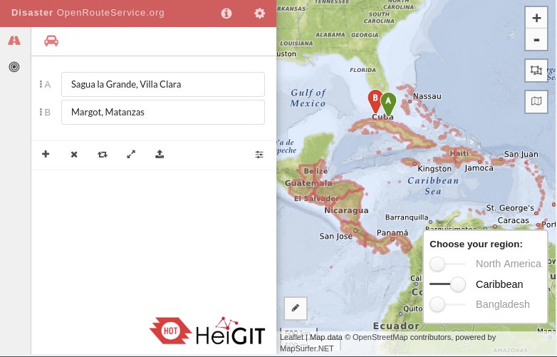
- [1] Luisa Janine Griesbaum reported in GIScience News Blog of the University of Heidelberg, that GIScience Heidelberg/HeiGIT updated their OpenStreetMap based Disaster OpenRouteService (a special version of OpenRouteService.org) to the following routing regions North America (incl. Mexico), Caribbean, Bangladesh in order to support the mapping and rescue activities. The data is currently updated every 24h (around 21:00 CET – thanks to Geofabrik).
- HOT Activates for Three Disasters
- HOT and the United Nations High Commissioner for Refugees (UNHCR) are working together to map refugee settlements in Uganda. A mapathon was organized and 18 international aid agencies participated.
- Brynne Morris from Mapbox writes a blog which consists of the recovery and relief maps that were made for Hurricane Harvey and also calls the community to contribute to Harvey relief efforts and improve the map in communities that are immediately in the path of Harvey.
- MAPS.ME and Humanitarian OpenStreetMap Team Partner to Crowdsource Data for Humanitarian Response
Maps
- OpenStreetBrowser now supports permalinks (as reported last week) which codes your current map position, opened categories and opened map objects. It is now easier to share data.
- pnorman would like that ‘
place=*tags on admin-relations should be rendered so that errors in tagging are visible. In the discussion on Github, it is proposed that instead the corresponding border relations in the United States should be corrected.
switch2OSM
- Nicolas Dumoulin informs the Talk-fr discussion group about discussions with the “Conseil départemental du Puy-de-Dôme”. A Mapping party is planned and various POI should be added to the map.
- Entur is a company owned by the Norwegian government tasked with building a multi-modal public transport planner for all of Norway. The travel planner uses OpenTripPlanner, which in turn uses OSM for foot routing.
Open Data
- The @MFFP_Quebec, Canada, published for the first time dendrometrical maps under the License cc-by-4.0.
Releases
The JOSM stable release 12712 was published on the 17th of August. It adds Java 9 compatibility, and improves the dialogue for Overpass API download and search based on presets are special highlights. Bogdans Afonins worked on those 2 features as part of GSoC 2017. We want to thank the whole JOSM developer team for their continued efforts to provide us this great editing tool.
Did you know …
- … the new overview to clean up errors on OSM provided by Mapbox?
- Update … Windy.com, an OSM based live map which shows wind activities (clouds, temperature, cloud tops, cloud base, waves and much more besides) worldwide? Windy is also available as an application for mobile phones. (Apple, Android) – Windy.com uses OpenStreetMap data without proper attribution as required by the OpenStreetMap License. See it here on Lacking proper attribution. See the discussion on talk as well.
OSM in the media
- Risques climatiques
 (automatic translation)
 - Le Monde (France) reports about the HOT mapping efforts in response to Hurricane Irma.
 (automatic
 Other “geo” things
- A map showing Hurricane Irma translated to Europe may have exaggerated it’s size. SK53 corrected the projection onto Mercator corrected.
- Glenn Bech shares a 3D print of his OpenStreetMap export from New York, you can also have one for yourself using ‘Thingireverse‘.
- Map Stylizer, version 1 of a web app to create highly stylized (and not-so-useful) maps.
- Paul Plowman explains how he discovered two adjacent houses on the same road with the same housenumber.
Upcoming Events


Note: If you like to see your event here, please put it into the calendar. Only data which is there, will appear in weeklyOSM. Please check your event in our public calendar preview and correct it, where appropriate.
This weeklyOSM was produced by Nakaner, PierZen, Polyglot, SK53, SeleneYang, Spanholz, derFred, doktorpixel14, ec, jinalfoflia, keithonearth, sev_osm.