19/04/2022-25/04/2022

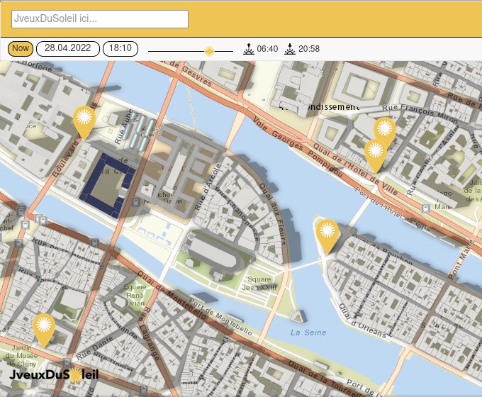
Where one can sit out in the sun [1] © JveuxDuSoleil.fr| Leaflet | Powered by Esri | OSM Buildings | map data © OpenStreetMap contributors
Mapping campaigns
- At the end of April Mapbox is going to start a mapping project in Romania. The team is planning to review a subset of detections, among others, of ‘crossing highways – roads with no common point’, ‘impossible angle – roads with too narrow angles’, and ‘mixed layer – connected roads with different layers’. They have asked the mapping community in Romania for feedback.
Mapping
- Anton Khorev has devised a workaround for viewing notes in iD by remote control.
- Becky Candy outlined her common feedback that she gives to mappers while validating building projects on HOT’s tasking manager.
- The ‘Project of the Month Switzerland’ for April is about the collecting of sustainable offers, i.e. stores and vending machines that are organic, regional, unpackaged, fair trade or second hand, and vegetarian and vegan restaurants as well as food sharing including water refill.
- solenoid jam shared
>
his experience of adding CCTV cameras to OSM.
Community
- FlawOfAverages has made good use of the Corona time. In his blog post, he described how it came about, what he mapped, and explains why he doesn’t recommend mapping 365 days a year.
- Minh Nguyen shared his views about the value of multilingualism being essential for a project such as OpenStreetMap and how the wiki translate extension could fit under that idea.
- raphaelmirc has invited
>
you to join the ‘UMBRAOSM / Union of Brazilian Mappers of OpenStreetMap’ Telegram Group to inform yourself about its activities and support its projects.
- Peter Van Geit, a Belgian who has lived in India for 20 years, has published five detailed illustrated reports on his website since 10 April under the title ‘Mapping Jammu & Kashmir’. He states that he has mapped ‘tens of thousands of features in OSM: Mountain passes, peaks, glacial lakes, remote settlements, rivers and streams, and more than ten thousand hiking routes (accurately recorded with GPS)’.
OpenStreetMap Foundation
- The OSMF published a chat with Grant Slater, the OpenStreetMap Foundation’s new Senior Site Reliability Engineer.
Events
- For the next SotM, running from 19 to 21 August in Firenze, Italy, you may be able to benefit from the OSMF Travel Grant Programme. Apply soon but no later than 6 May 2022, 23:59:59 UTC for support to participate.
- The HOT Humanitarian Open Mapping Community Working Group will hold a Zoom webinar about ‘how open source geodata is used in the context of environmental management to achieve sustainable development goals’. Two sessions will be held, in French on Friday 6 May and in English on Friday 13 May, both at 12:00 UTC.
- Check out the YouTube videos from the 2022 State of the Map US. Among the many presentations, one of our editors found ‘An American Map Style’, by Brian Sperlongano, very interesting.
Maps
- [1] The JveuxDuSoleil (‘GimmeSomeSun‘) association released a web map using building information from OpenStreetMap data to show where you can sit in the sun.
Software
- Mykola Kozyr noted that the QGIS OSMDownloader plugin loads OSM data plus a style layer imitating the CartoCSS, used by default on the OSM main page.
- The 2022 Desertus Bikus is taking place from 23 April to 1 May. You can follow each participant’s position, in this bicycle race through Spain, by using the LegendsTracking live map, which uses an OpenStreetMap basemap (credits hidden behind the sadly anonym ‘i’).
- Johan Morganti has built an OpenStreetMap data dashboard using a Datadog framework. A live demo showing multiple statistics on OSM changesets can be found here.
- Trufi Volunteers in Bolivia celebrated the release of Trufi App V3: 100 new bus routes mapped in OSM. Users can track and submit missing routes.
Programming
- Isaac Brodsky explored OpenStreetMap data using Unfolded Studio, a geospatial analysis and viewer tool, and showcased the high resolution of H3 grid cells.
Did you know …
- … the PingPongMap? Peter Ulrich shows us ping pong tables all over the world using an OSM background map.
OSM in the media
- Supaplex wrote about the ‘Hong Kong peak names edit wars’. Hikers and orienteers had expressed concerns about the reliability of OSM as reported
>
by the magazine Sportsoho.
Other “geo” things
- Levente Juhasz and Peter Mooney published an article about the most real of fictional places ‘Null Island’. A technological place built from errors in data resulting in many things being found in the region of (0,0).
- Joe Morrison took a look at the satellite image industry and its mistake in aiming for a one-size-fits-all derived data subscription based product derived from imagery.
Upcoming Events
Note:
If you like to see your event here, please put it into the OSM calendar. Only data which is there, will appear in weeklyOSM.
This weeklyOSM was produced by Lejun, Nordpfeil, PierZen, SK53, Strubbl, TheSwavu, derFred.