2024/08/15-2024/08/21

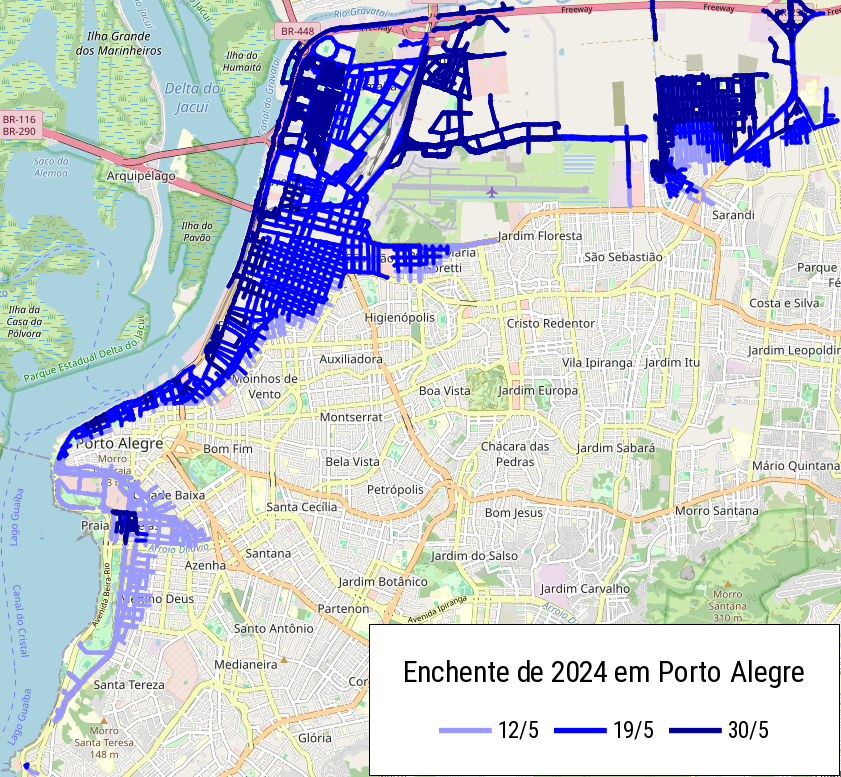
繪製2024年南里約格朗德州洪水 [1] | © ftrebien | 地圖資料 © OpenStreetMap 貢獻者
畫地圖
- [1] ftrebien 描述了
>
因2024年巴西南里約格朗德州災難導致的道路封鎖、毀壞與重建,以及他為此而進行的努力,詳細介紹了在不可靠的商業地圖、零散的官方資料與假新聞中使用準確資訊更新 OpenStreetMap 的挑戰,同時也強調了災難對當地基礎設施與社群的影響。他的工作尚未完成!
- 旋轉木馬上顯示了一個帶有速限的路標,以及有關自動駕駛汽車在上午8點至晚上9點之間運作的通知。他質疑它的含義,並詢問
OpenStreetMap 上是否有任何關於它的地圖建議。
- 以下提案正在徵求評論:
社群
- Ian Dees 分享了他使用 OpenAI API 根據影像建議 OpenStreetMap 標籤的實驗。他開發了一種為影像產生標籤推薦的工具,旨在簡化 OSM 貢獻者的繪製流程。該工具目前正處於測試階段,有一個原型可供回饋,Dees 正在探索在不直接向 OSM 新增資料的情況下改進輸出的方法。
- Perkumpulan OpenStreetMap Indonesia (POI) 與 OSM 印尼社群已經完成並釋出了 OSM ID 標記指南,該指南標準化了 Wiki Map 功能與 OpenStreetMap Taginfo 的印尼物件的 OSM 標記。該指南還提供了印尼語版本,提供給印尼的 OSM 使用者並提高 OSM 資料品質。
- 德國聯邦製圖與大地測量局已發起招標,以評估 OpenStreetMap 資料的品質。
- kaccin 討論了一個僅限
居民造訪的位置,並強調 OpenStreetMap 缺乏關於週邊地區的詳細資訊。他反思了由於存取與資料可用性有限而繪製這些地方地圖所面臨的挑戰。
- Verkehrsgemeinschaft Mittelthüringen(位於德國圖林根中部的大眾運輸機構)正在尋找
顧問或講師,以協助正確繪製大眾運輸路線與站點以及使用 JOSM。
開放街圖基金會
- 2024年8月29日星期二21:30 UTC+8 舉行,包括以下有趣的討論主題:
- 財務報告
- 會員以及 CiviCRM 工作小組
- 地方社群與溝通工作小組更新:10月份OSM 31日挑戰
- 地方社群與溝通工作小組更新:支援在地 SotM 大會的相關議程
- 對剽竊 OSM 資料與不使用 OSMF 圖磚伺服器的資料使用者採取行動
- DSGVO 更新
- 簡報 – OSM 哥倫比亞與/或拉丁美洲
活動
- IVIDES.org 繼續宣傳 OpenStreetMap 20 週年紀念活動,其中包括在南里約格朗德州今年受重大災難影響的城市之一舉辦繪圖松。Raquel 在她的日記
>
中感謝 TomTom 贊助了兩張優惠券,這些優惠券將在活動最後一天(8月30日)進行抽獎。
- OpenStreetMap 成立於2004年7月,距今幾乎整整 20 年了。Falk Zscheile 的演講
回顧了 OSM 計畫這段時間的發展,也敢於展望未來。除此之外,還對資料品質、社群、法律與好奇心等方面進行了審查。
- State of the Map Latam 是拉丁美洲所有地圖創作者與 OpenStreetMap 使用者的年度會議。在此版本中,活動將免費、現場進行,地點在巴西。演講與論文的遞交截止日期為2024年8月31日。
OSM 研究
- 在 ACL 的《Findings》中發表的一篇研究論文中,Paz-Argaman 與其他人(巴伊蘭大學與 Google Research)描述了他們如何使用 OSM 資料以自然語言生成導航指令,就像人類將它們傳遞給另一個人一樣(「在花園裡等我。向西北走……花園就在一家速食店旁邊,如果你到達一家美甲沙龍,你就走得太遠了。」)他們的目標是改進人工智慧系統,在給定地圖的情況下,起點和導航指示,嘗試確定目標座標。產生導航指令需要識別與路線相關的顯著地標,因此他們也描述如何使用 OSM 標籤來識別地標。
地圖
- Christoph 討論了將高解析度 10 公尺衛星影像涵蓋範圍擴充到西亞,重點關注「Musaicum」計畫。該計畫旨在提高該地區地理空間資料的準確性與細節,並應對與沙漠與山區地形相關的具體挑戰。他還談到了影像處理的技術方面以及這些改進的資料在繪製與環境研究中的潛在應用。
OSM 的實際應用
- dcapillae 一直致力於改進
>
西班牙馬拉加市墳墓與殯葬建築的繪製。這座城市有兩個歷史悠久的公墓,都被列為文化名勝:英國公墓
►
與聖米格爾歷史公墓
►
。他正在使用 uMap 複製聖米格爾公墓的平面圖,其中包括歷史人物墳墓與陪葬紀念碑的地理位置。
- 網路地圖「Welcome To My Garden」由非營利公民網路維護,在其花園中向旅客提供免費露營點。該軟體可在 GitHub 上的頁面專案中取得。
軟體
- 在電話瀏覽器上開啟 Pifomap
是一個奇怪的想法。截至目前為止,除非您想失去您的眼睛與神經,否則強烈建議不要。但從今晚開始,情況就大不相同了:Pifomap 現在有了可用的行動版本
!
- MAPS.ME 團隊講述了
應用程式中公車導航的實現以及為此必須解決的問題。 MAPS.ME 也部署了全球巴士路線驗證器。
程式開發
- Jochen Topf 討論了他在使用 Osmium 工具處理大型資料集時發生的「記憶體不足」錯誤的經驗,解釋了技術挑戰以及他除錯與解決問題的方法,其中包括分析記憶體使用情況與改善程式碼以處理大型 OpenStreetMap 資料更有效率。
釋出
- 由於 Organic Maps 應用程式意外從 Google Play 商店中刪除,該應用程式於2024年8月發布的時間已被推遲。該團隊正在積極努力解決問題並還原應用程式,而使用者仍然可以直接從其網站下載 APK。
你知道嗎?
- OSMF 為希望成為 OpenStreetMap 基金會活躍貢獻者成員的個人提供了一份申請表,特別是透過非地圖活動獲得資格的貢獻者。此表格收集個人資訊,概述資格標準並解釋申請人的遞交流程。
- ……Bangle.js,用開放韌體觀看,當然有檢視 OpenStreetMap 地圖的應用程式?
- ……FixMyStreet 網站使用 OSM 為基礎的地圖?FixMyStreet 整合了互動式地圖,讓使用者可以標記坑洞或非法垃圾等問題的確切位置,然後將其報告給相關當局。FixMyStreet 是開放原始碼,可在 GitHub 上取得。
- ……Volker Schatz 十多年前發布的 OpenStreetMap 駭客指南,其中提供了關於 OSM 地圖自訂設定的提示?
- ……WikiShootMe?該工具讓使用者在地圖上找到維基媒體計畫需要照片的位置,突出顯示缺乏影像的區域,並鼓勵為改善維基百科、維基數據與維基共享資源的涵蓋範圍做出貢獻。
媒體中的 OSM
- OpenStreetMap 作為開放式協作地圖平台正在慶祝其成立20週年。隨著時間的推移,該計畫的發展如何?OSM 可以與商業提供者競爭嗎?開源理念對數位製圖的未來代表著什麼?德國光纖擴張的資金撥付進展緩慢,您可以在《Head topics》中發表
>
的文章以及觀看 heise & c’t 頻道
上的影片以了解更多相關資訊。
其他地理事情
- Wheelmap.org (基於 OSM 的無障礙設施 app) 正尋覓在德國柏林工作的全職 (Node.js、TypeScript、Kubernetes) 的全端開發者。
- Red Blob Games 討論了在地圖上有效放置標籤的挑戰與策略,強調可讀性與避免重疊之間的平衡。它探討了用於最佳化標籤放置的不同演算法與技術,例如固定位置與動態標籤之間的權衡,以及如何在互動式地圖中應用這些方法。
未來活動
註: 你也可以在這裡展示你發起的活動!只須在行事曆上塡妥活動資訊即可。 只有記載於行事曆上的活動資訊才會在《週刊OSM》列出。你也可以在行事曆預覽檢查你提交的活動, 並作出適當更正。
這期 weeklyOSM 由 MatthiasMatthias, Raquel Dezidério Souto, Strubbl, Supaplex, TrickyFoxy, derFred, mcliquid, miurahr, s8321414 編譯 ##team##
The events are listed twice. E.g., OpenStreetMap x Wikidata Taipei #68 .
For the “Upcoming Events” section…
Would it be more readable to flip the columns into this order?
– Date
– Country
– Where
– What
Currently, your eyes have to jump between dates/flags, then city names.
(And many cities, like “Rostok”, you may not even be familiar with… but paired with the German flag, you can then quickly see if it applies to your location or not.)
We have put your good idea into our backlog. Thank you very much.