28/07/2020-03/08/2020
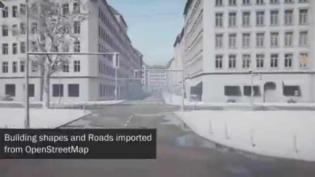
Stina Flodström‘s video created with FOSS data 1 | © Stina Flodström | map data © OpenStreetMap contributors
Mapping
- A blog post on The Strava Club reminded users that they can help improve the quality of suggested routes by contributing to OpenStreetMap.
- The members of OpenStreetMap Italia community have created su.openstreetmap.it, a website where you can add businesses in Italy to OSM without having an account. They have recently added a written and video tutorial with a step by step explanation. The news has been covered
 (automatic translation) by Wikimedia Italia with a short article. The source code of the website is available on GitHub.
 - Skunk published in his blog post a entry titled ‘Mapping artwork and memorials with Wikimedia integration’.
- Jake Coppinger reviewed a number of bicycle routing apps and ranked them in rough order of which he would use for commuter cycling in Sydney.
 (automatic
 Community
- User mariotomo writes (automatic translation) about his ‘reflections on the margins of the SotM-2020 virtual conference’, in particular from the perspective of being on a low bandwidth connection.
- OpenStreetMap US has been awarded a Geospatial Data Analytics Services Grant for the Azavea Summer of Maps programme. Eugene Chong will be using OpenStreetMap to track (and map) progress made on UN Sustainable Development Goals in several American cities.
- On System Administrator Appreciation Day Dorothea thanked our sysadmins for the awesome work that they are doing.
 (automatic
 OpenStreetMap Foundation
- Mikel Maron wrote an email about ‘coordinated funding to support continued maintenance and development of the iD editor’.
- Guillaume Rischard announced, on talk, the funding of three infrastructure projects: Nominatim, osm2pgsql and Potlatch 2 by the OSMF Board. Technical issues were discussed among others by Sören Reinecke, Richard Fairhurst and mmd.
- The OSMF Board is considering splitting the Advisory Board in two and is seeking input on this move.
- The minutes of the OSMF Board meeting on 30 July have been published.
- Imagico ponders in his blog post about ‘the how and where of the OSMF starting to hand out money in the OSM community’.
Humanitarian OSM
- Médecins Sans Frontières held a missing maps mapathon on 1 August with volunteers from all over Southeast Asia. The mapathon is part of the organisation’s plan to map out Nigeria this year.
- Despite movement restrictions in the country, HOT Philippines has been able to continue training volunteers by identifying their needs and shifting training efforts online.
- YouthMappers, CommonSensing and other members of the humanitarian mapping world were covered in an article by Gareth Willmer on Devex.
Maps
- Three students created a website gathering all kinds of data related to cycling. The first version of the tool is online. The mapathon to collect data, and create a complete website to document the entire making process, was organised by Open Knowledge Belgium. They are asking for feedback.
- Peter Corless discusses how Stadia Maps improved their end-to-end latency by switching from CockroachDB to Scylla.
- After Taiwan passed the National Language Law, the Hokkien Language, mixed with Austronesian and Japanese terms, known as Taiwanese or Taiwanese Hokkien, gained official language status in Taiwan. Brandon Liu will talk about the Taiwan Taigi Map in COSCUP, one of the most important open source conferences in Taiwan. The Taiwan Taigi Map lets people explore
name:nantags which record local Hokkien names.
switch2OSM
- For some time the City of Karlsruhe has been using the API of Openrouteservice (ORS), developed by HeiGIT, to prove a routing service for pedestrians, bicycles and cars for their online city map and citizen GIS app (for citizens and visitors to Karlsruhe). You can try it here:
The client developed by the Liegenschaftsamt (land management department), city of Karlsruhe is based on the ArcGIS for Javascript API and built as a widget for the ArcGIS Web AppBuilder.

Software
- Can Yang has written a tutorial on map matching using their fast map matching library and OpenStreetMap data.
- Misiones Provincial Routes (automatic translation) is a tool built with institutional and collaborative contributions, such as OpenStreetMap, Mapillary, Wikipedia, and Openrouteservice. Developed by the Dirección de Modernización de la Gestión y Gobierno Electrónico de la Provincia de Misiones, Argentina, it is an interactive map to virtually travel provincial routes and roads. Carlos Brys, one of the developers, gives (automatic translation) more details in a Primera Edicion article.
- Ilya Zverev explained (automatic translation) how a combination of ancient anonymous edits and a new JSON output option for the OSM API caused problems for iD.
 (automatic
 Programming
- GIScience Heidelberg open-sourced the ohsome2label tool, which offers a flexible framework for labelling customised geospatial objects using historical OSM data allowing more effective and efficient deep learning. Based on the ohsome API developed by HeiGIT gGmbH, ohsome2label aims to mitigate the lack of abundant high-quality training samples in geospatial deep learning by automatically extracting customised OSM historical features, and providing intrinsic OSM data quality measurements.
- Fabian, from HeiGIT, explained the new function in the ohsome (OSM history Analytics) API for checking query parameters. The API now uses a fuzzy string matcher to suggest which parameter you meant to pass when it encounters one it doesn’t recognise in your query.
- [1] Stina Flodström has produced a pipeline importing OpenStreetMap data into Unity, using Houdini (here is the free version for testing), to generate real time environments based on real cities. You must see the video!
Releases
- Stable release 20.07 of JOSM has been released.
Did you know …
- … that you can draw a bounding box on a map and Norbert Renner’s bbox tool will return its coordinates in a number of different OSM formats?
- … there is a wiki page listing websites that are using OSM data without correct attribution? The page also describes the steps to follow if you discover another example of missing attribution.
- … that OpenHistoricalMap is built by a community of mappers and historians that contribute and maintain data about the history of the world?
- … that Public Transport Network Analysis (PTNA) provides a daily analysis of public transport lines mapped in OSM?
Other “geo” things
- Bored Panda showed us their favourite maps from Terrible Maps.
- It’s been hot enough recently to prompt Alexander Zipf to remind us that a shady route feature is available for Heidelberg and Dresden in the meinGrün app (automatic translation).
- Burb (ˈbərb) v. the act of cycling every street of a suburb in a single ride, a variant of the Chinese postman problem. Matt and Andy competed with Jim’s optimiser to find the shortest route to burb Bellfield.
- Microsoft’s latest release of Flight Simulator is more of a vast, gamified take on Google Earth than it is a simulation of flight. Keith Stuart describes how the game presents a near-photorealistic depiction of the entire planet, featuring cities procedurally generated by AI, based data from OpenStreetMap.
- Antony Barja is excited about North Road’s new SLYR ArcMap to QGIS compatibility suite. The new tool automatically converts ArcMap MXD, MXT and PMF documents to QGIS projects, Esri LYR files to their QGIS equivalents, and Esri .style databases.
- Laura Bliss writes on Bloomberg CityLab about the pandemic-era appeal of getting lost in a labyrinth, and links to the world wide labyrinth locator. On OpenStreetMap, the
attraction=mazetag is used about 800 times.
Upcoming Events
| Where | What | When | Country |
|---|---|---|---|
| Michigan | Michigan Online Meetup | 2020-08-08 | USA |
| Taipei | OSM x Wikidata #19 | 2020-08-10 |  |
| Hamburg | Hamburger Mappertreffen | 2020-08-11 |  |
| Munich | Münchner Stammtisch | 2020-08-12 | |
| Berlin | 146. Berlin-Brandenburg Stammtisch | 2020-08-14 | |
| Zurich | 120. Mapping-Party/OSM Meetup Zurich | 2020-08-15 |  |
| Cologne Bonn Airport | 130. Bonner OSM-Stammtisch (Online) | 2020-08-18 | |
| Lüneburg | Lüneburger Mappertreffen | 2020-08-18 | |
| Berlin | 14. OSM-Berlin-Verkehrswendetreffen (Online) | 2020-08-18 | |
| Cologne | Köln Stammtisch ggf. ONLINE | 2020-08-19 | |
| Derby | Derby pub meetup | 2020-08-25 |  |
| Düsseldorf | Düsseldorfer OSM-Stammtisch | 2020-08-26 | |
| Kandy | 2020 State of the Map Asia | 2020-10-31-2020-11-01 |  |
Note: If you like to see your event here, please put it into the calendar. Only data which is there, will appear in weeklyOSM. Please check your event in our public calendar preview and correct it, where appropriate.
This weeklyOSM was produced by AnisKoutsi, LorenzoStucchi, MatthiasMatthias, Nordpfeil, NunoMASAzevedo, PierZen, Polyglot, Rogehm, TheSwavu, derFred, muramototomoya, osmapman, richter_fn.