06/07/2021-12/07/2021
Request for comments barrier=cycle_barrier [1]
Chi siamo
- Errata: l’interfaccia web di StreetCompleteness
 che elenca la percentuale di completamento per alcune missioni StreetComplete selezionate (che abbiamo riportato la scorsa settimana) non è stata creata da Tobias Zwick, che ha creato l’app StreetComplete, ma da Wieland Breitfeld. Ci scusiamo per l’errore.
 - Buone notizie: Il nostro collaboratore e traduttore coreano, Donga Hwang aka LuxuryCoop è tornato dal suo dovere di co-lettore e quindi la nostra edizione coreana è tornata dalla scorsa settimana. 😉
 che elenca la percentuale di completamento per alcune missioni StreetComplete selezionate (che abbiamo
 Progetti di mappatura
- TomTom ha creato > cinque sfide MapRoulette volte a controllare e migliorare OSM per la navigazione dei veicoli. Ogni sfida copre una parte diversa dell’Africa e TomTom indica che si basano sia su strumenti regolari di controllo della qualità OSM, come Osmose, sia su dati e convalide interne a TomTom. Non vengono forniti dettagli sui tag da modificare.
- Edoardo Neerhut ha annunciato > su talk-au che OSGeo Oceania ha stanziato 2.500 dollari australiani per un finanziamento dedicato a iniziative legate a OpenStreetMap
- Il progetto del mese di luglio dell’associazione svizzera OSM è mirato > al miglioramento dei dati dei campeggi e dei siti di pernottamento per veicoli ricreativi (roulotte o camper). Istruzioni dettagliate sono disponibili nel wiki > .
- Il terzo progetto trimestrale britannico del 2021 è incentrato > sul turismo: strutture e aree di interesse per i visitatori, come hotel, parcheggi per roulotte, snodi del trasporto pubblico, sentieri pubblici e luoghi di interesse storico.

Mappatura
- Il nome dello Schneeberg, una montagna austriaca, si è rivelato > essere controverso. Si tratta di un altopiano calcareo ondulato dai lati ripidi con diverse cime (vedi questo vecchio resoconto > su altri aspetti della mappatura della zona). Il problema è che apparentemente non c’è un buon modo per nominare l’intera area su OSM, e quindi alcuni hanno sostenuto di usare il nome della cima più alta o di aggiungere il nome della area a quella cima “Klosterwappen (Schneeberg)”.
- AngocA ha delineato > il suo punto di vista e la sua esperienza con le note OSM in un dettagliato post nel suo diario.
- PkBuzios ha parlato > dei suoi progressi di mappatura nell’ex università Seale-Hayne, situata nel Devon, Regno Unito.
- [1] Sono stati richiesti commenti sulle seguenti proposte:
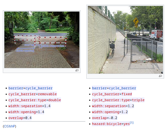
defensive_structure=*per etichettare le strutture difensive in tutte le fortificazioni moderne e storiche.man_made=video_wallper la mappatura dei grandi schermi digitali.barrier=cycle_barrierestendere l’etichettatura per le barriere ciclabili al fine di determinare la percorribilità di questo tipo di barriere per diversi tipi di veicoli, in particolare bici da carico, bici con rimorchio o sedie a rotelle.
- Le votazioni sulle seguenti proposte sono chiuse:
leisure=bathing_place La proposta di contrassegnare un luogo utilizzato per la balneazione e il nuoto non ha avuto successo con 8 voti a favore, 9 voti contrari e 3 astensioni.building=fire_lookouteemergency=fire_lookout, per etichettare le vedette antincendio, è stata approvata con 21 voti favorevoli, 2 voti contrari e 1 astensione.- La proposta del survey marker di sondaggio per etichettare la struttura, la condizione e lo scopo di un marcatore di sondaggio, è stata approvata con 13 voti a favore, 2 voti contrari e 5 astensioni.
 >
>  >
> Comunità
- Amanda McCann la settimana scorsa ha pubblicato i suoi “rapporti di attività” per aprile > , maggio > e giugno > .
- La comunità OSM Iran piange [fa] un giovane collaboratore, Mohammed Reza Norouzi. (La traduzione è disponibile sul sito twitter).
OpenStreetMap Foundation
- L’Engineering Working Group > sta ripartendo con un nuovo statuto. Mikel Maron ha condiviso > una bozza dello statuto proposto e la OSM Foundation sta cercando un feedback.
Eventi
- Martijn van Exel riferisce > su State of the Map 2021 dal punto di vista degli editor basati sui tasks e MapRoulette.
OSM research
- Oliver Fritz riferisce > che il simposio AGIT 2021 > ha accettato un nuovo documento di un team di ricerca HeiGIT . Il documento discute un approccio diverso all’analisi globale della completezza dei dati OSM. Questo viene realizzato generando dati di riferimento da indicatori demografici e socio-economici, così come da set di dati aperti sporadicamente disponibili secondo lo standard General Transport Feed Specification (GTFS) attraverso un modello di regressione.
- Linda Sendlinger riporta > una pubblicazione di Yeboah et al. riguardante l’analisi della qualità dei dati OSM per diverse fasi del processo di mappatura nelle baraccopoli. Gli autori hanno sviluppato quattro nuove definizioni di completezza basate sul numero totale, la lunghezza e l’area degli oggetti OSM. Tutte le definizioni sono state formate a intervalli di tempo arbitrari, permettendo di valutare la completezza di questi oggetti in qualsiasi momento durante il processo di mappatura, così come la stima delle potenziali disparità.
- Michael Szell e colleghi hanno usato > i dati di OpenStreetMap per esplorare i limiti della crescita di diversi modelli di rete ciclabile urbana prima di mostrarla .
OSM e l’azione umanitaria
- Spatial Collective, Humanitarian OpenStreetMap Team e OpenMap Development Tanzania hanno tenuto > un workshop conclusivo con i funzionari governativi per condividere la metodologia, i dati raccolti, e hanno avuto discussioni su come possono essere utilizzati i dati per la gestione dei disastri e la riduzione del rischio a Ilemela e Nyamagana. L’obiettivo era quello di assicurarsi di avere i dati raccolti, aggiornare e aggiungere altri dati in base alle loro esigenze utilizzando software libero e open-source e altri strumenti economici utilizzati nella raccolta dei dati.
- Sette comunità OSM in Tanzania sono state selezionate > per ricevere un Microgrant di impatto comunitario di OpenMap Development Tanzania.
- OpenMap Development Tanzania ha recentemente tenuto > il suo primo workshop per potenziali candidati Open Skies Fellows . Sedici persone provenienti da diverse regioni della Tanzania continentale e Zanzibar hanno partecipato. I candidati sono stati esposti a diverse tecnologie tra cui i droni e la stampa 3D. Hanno imparato ad assemblare stampanti 3D e a progettare, assemblare e far volare i droni, così come a pianificare le missioni dei droni.
- HeiGIT , TdLab Geography e il gruppo di ricerca GIScience dell’Università di Heidelberg stanno collaborando > al progetto transdisciplinare HEAL che supporta le persone, specialmente i gruppi a rischio, durante le ondate di calore. Questo viene realizzato coinvolgendo i gruppi target e le parti interessate, così come integrando i dati pubblici delle smart city in un sistema di routing.
Open Data
- La startup Geoalert ha pubblicato l’aggiornamento di Open Urban Mapping utilizzando le nuove immagini satellitari di Mapbox che hanno lo scopo di contribuire a OSM. Il numero di impronte di edifici estratti è aumentato di x2,5. Raccontano > perché la Cecenia è la più scarsamente mappata tra tutte le regioni della Russia.
Software
- AntoJvlt ha fornito > alcune informazioni sul suo progetto “Nominatim QA Analyser Tool”, capace di analizzare il database di Nominatim per estrarne dati sospetti e presentare i risultati in un’interfaccia grafica in modo da poterli correggere.
- Baato ha annunciato > la beta release di uno strumento per confrontare la mappatura OSM di una particolare area in due momenti diversi, facilitando così i confronti prima-dopo.
- L’applicazione Android GeoNotes > di hauke-stieler riceve feedback di tanto in tanto e nel frattempo sono state apportate alcune modifiche. Tra le altre cose, è stata aggiunta l’esportazione in GeoJson, una lista di tutte le note e un’opzione di feedback via email per gli utenti non-GitHub.
- goodudetheboy dà un aggiornamento > sui progressi dell’OpeningHoursEvaluator e anche una prospettiva per i prossimi passi.
Programmazione
- rainerU mostra > come usare la shell UNIX bash per scaricare le posizioni delle sequenze di Mapillary in un dato bounding box e convertirle in un formato utilizzabile come overlay su un GPS Garmin.
- Ujaval Gandhi annuncia un importante aggiornamento al suo Mastering GDAL Tools > su SpatialThougths (accesso gratuito al materiale del corso).
- Yunzhi, una dipendente di Facebook descrive > in un post sul suo diario esempi di come Facebook utilizza processi di convalida automatica per trovare dati errati in OSM prima di creare il loro fork “Daylight”.
Lo sapevi che…
- … che è possibile utilizzare osm-tile-access-log-viewer di Martin Raifer per visualizzare i log delle piastrelle visualizzate di frequente di cui abbiamo parlato la scorsa settimana?
OSM nei media
- L’Addison County Independent ha intervistato > Adam Franco, collaboratore di OSM e creatore di Curvature > , un sito web per pianificare giri in moto su strade tortuose.
Altre cose “geo”
- L’utente Reddit Morwon ha postato > due versioni di una mappa della popolazione dell’Europa dove ogni quadrato rappresenta ~500 000 persone
- Il thread di geoweirdness della settimana di OpenCage è sul Sudafrica 🇿🇦
Prossimi eventi
| Dove | Cosa | Online | Quando | Nazione |
|---|---|---|---|---|
| OSM Africa Monthly Mapathon: Map Nigeria | 2021-07-02 – 2021-08-02 | |||
| NetHope webinar: Mapping With AI and Communities | 2021-07-20 | |||
| Derby | 2021-07-20 |  | ||
| Bonn | 141. Treffen des OSM-Stammtisches Bonn | ✓ | 2021-07-20 |  |
| Berlin | OSM-Verkehrswende #25 (Online) | 2021-07-20 | | |
| City of Nottingham | OSM East Midlands/Nottingham meetup (online) | ✓ | 2021-07-20 | |
| Lüneburg | 2021-07-20 | | ||
| Lüneburg | Lüneburger Mappertreffen (online) | 2021-07-20 | | |
| Charla/taller en línea de introducción a OpenStreetMap | 2021-07-21 | |||
| Berlin | Missing Maps Ärzte ohne Grenzen Mapathon | 2021-07-21 | | |
| Virtueel treffen OpenStreetMap NL | 2021-07-24 | |||
| Bogotá Distrito Capital | Resolver notas de Bogotá creadas en OpenStreetMap | 2021-07-24 |  | |
| Bremen | Bremer Mappertreffen (Online) | ✓ | 2021-07-26 | |
| Ville de Bruxelles – Stad Brussel | Virtual OpenStreetMap Belgium meeting | ✓ | 2021-07-27 |  |
| Aubière | Rencontre OpenStreetMap Clermont | 2021-07-28 |  | |
| Zürich | Missing Maps Zürich Mapathon | 2021-07-28 |  | |
| Düsseldorf | Düsseldorfer OSM-Treffen (online) | 2021-07-28 | | |
| [Online] OpenStreetMap Foundation board of Directors – public meeting | 2021-07-30 | |||
| 臺北市 | COSCUP 2021 OpenStreetMap x Wikidata 開放內容議程軌 (CfP) | 2021-07-31 – 2021-08-01 |  | |
| London | Missing Maps London Mapathon | 2021-08-03 | | |
| Landau an der Isar | Virtuelles Niederbayern-Treffen | ✓ | 2021-08-03 | |
| Nordrhein-Westfalen | OSM-Treffen Bochum | 2021-08-05 | |
Nota: Se vorresti vedere qui elencato il tuo evento, per favore inseriscilo nel calendario. Solo i dati che sono inseriti lì appariranno nel notiziario.
Questa Notiziario Settimanale OSM è stato prodotto da Climate_Ben, LorenzoStucchi, SK53, TheSwavu, alesarrett, derFred.
Hello, Africa OSM,
Here is some additional clarity for our Africa QC projects that I hope can be helpful!
Additional, challenge-specific information for proposed fixes and/or tag updates appears within each challenge description. And, it is possible that some challenges will occasionally show only a few or no tasks, but this is temporary. We will update these challenges as new data becomes available—simply check back in a few days.
(Veuillez accepter mes excuses pour ne pas avoir écrit en français.)