19.10.–25.10.2021
Open Data a OpenStreetMap [1] © Pascal Neis © přispěvatelé OpenStreetMap
OSM CZ
- Možnosti Locus Map pro mapování OSM – zobrazení nebo založení nové poznámky OSM.
- Propojený vesmír pro chatování o českém OSM se nově rozrůstá i o Telegram.
- Máte v Česku tabule pro označování hranic národních parků? A mohl bych ji vidět?
OSM SK
- Další zpřístupněná území pro DRM 5.0 na Slovensku.
- Jak co nejrychleji a nejjednodušeji přidat do mapy jedinou studánku?
- Jak sjednotit mapování městských částí a adres v nich pro Bratislavu a Košice?
- Je vhodné celé plochy obory tagovat s pomocí
landuse=farmyard?
Mapování
- Pascal Neis tweetuje o aktualizaci svého nástroje ‘Nezmapovaná místa OSM’. Letos bylo již identifikováno 331 000 míst, loni to pak bylo za stejný čas 339 000.
- Christian Rogel, který si nedávno koupil elektrickou tříkolku, navrhl
 > , že by mohl pomoct s radami ohledně tagování, které pomůže tricyklistům ve využívání existující cyklistické infrastruktury.
 - DENelson83 začal upravovat individuálně pojmenované části vod na atlantickém pobřeží Kanady na relace. Vysvětlil svůj postoj, ale i tak sklidil i negativní zpětnou vazbu.
- Alec Schulze-Eckel informuje o úspěšném konci projektu 25. mapathonu, kde se zformovala malá ale silná skupina dobrovolníků z německého Červeného kříže.
- MKnight sdílí > svou zkušenost s mapováním svodidel.
- CzerwonyPazdzierz se na fóru ptá > na místa, která jsou v OSM zmapovaná nejlépe. Kromě individuálních návrhů v tomto vlákně je zde také mapa ukazující poměr objektů v OSM a hustoty populace.
- Byla podána žádost o připomínky k
artwork_type=maypole, což je doplňkový tag kman_made=maypolepro umělecky hodnotné májky.
 >
> 
 >
>  >
> Komunita
- Čínská lokální komunita OpenStreetMap OSMChina spustila > svou webovou prezentaci > a nabízí dlaždicový server postavený na stylu OSM-Carto. Aktuálně server nabízí data jen pro kontinentální Čínu.
- Mateusz Konieczny se ptá na stav projektu HOT Tasking Manager, což vyvolalo další diskuzi ohledně kvality mapování a koordinace mapovacích projektů koordinovaných přes Tasking Manager. Arnalie Vicario z HOT reagovala informací o pracovních skupinách HOT pro kvalitu dat a zve jednotlivé přispěvatele k účasti na jejich příštím setkání 4. listopadu.
- Členka rady Nadace OSM Amanda McCann nabízí svůj pravidelný měsíční souhrn aktivit za měsíc září.
- BryDee informuje, že HOT Open Mapping Hub – Asia Pacific (OMH-AP) podepsal dohodu o společném záměru s kanceláří Asia Pacific Region (WSB/APR) Světové organizace skautského hnutí (World Organization of the Scout Movement, WOSM). Počáteční dohoda je na tři roky. BryDee vidí velký zájem ze strany skautů a co je důležitější také 30 milionů potenciálních mapperů OSM.
- GOwin informuje o dokončení úkolů OSMaPaaralan a za 2 roky a 22 dní bylo celkem zmapováno a zkontrolováno 39 129 škol.
- Někdo si na IRC kanálu #osm všiml, že když kdokoliv v komentáři k videu na YouTube zmíní ‘OpenStreetMap’, je příspěvek okamžitě smazán. Simon Poole o tom sdílí i tweet.
- Lejun hledá aplikaci pro mapování fasád domů. Popisuje svá zamýšlená kritéria a vyhodnocuje dostupné nástroje z pohledu vhodnosti pro daná účel.
- martien-vdg píše o svých představách, jak zlepšit kvalitu mapování nových mapperů.
- PlayzinhoAgro navrhuje změny stránky s uživatelským profilem OSM.
 >
> Nadace OpenStreetMap
- Dorothea Kazazi oznámila, že byly uzavřeny nominace pro příští volby do rady Nadace OSM. Na čtyři volná křesla v radě je těchto šest kandidátů:
- Guillaume Rischard, USA
- Michal Migurski, USA
- Amanda McCann, Německo
- Mikel Maron, USA
- Roland Olbricht, Německo
- Bryan Housel, USA.
Členové nadace mohou pokračovat v pokládání svých dotazů. Informace o kandidátech najdete na wiki stránce Candidate 2021. Informace o hlasování a další detaily najdete na wiki stránce Valné hromady 2021.
Události
- Nikdy jste nebyli v australském Perthu? Tak se tam vydejte v rámci konference FOSS4G SotM Oceania Perth Hub s workshopem na téma OSM v sobotu 13. listopadu.
- Konference State of the Map Africa 2021 se bude konat online v termínu 19. – 21. listopadu. Registrace je aktuálně otevřena a Geoffrey Kateregga zve žadatele o podporu pro internetová data pro umožnění vzdálené účasti pro ty, co to potřebují. Formulář pro podání žádosti je dostupný online.
- Pracovní skupina LCCWG rozšířila své pozvání pro vedoucí a členy lokálních komunit OpenStreetMap k účasti na konferenci 2021 Local Chapters and Communities Congress, který se koná virtuálně v sobotu 6. listopadu. Jsou vítáni i zástupci jiných uživatelských skupin OSM.
Výzkum OSM
- John Bryant z Overseas Development Institute zveřejnil pracovní verzi článku Digital mapping and inclusion in humanitarian response. Doplňuje, že mapy mohou přispět ke vzdálené podpoře a správě při reakci na katastrofy. Někteří humanitární pracovníci si také všimli, že mapa je často vnímána jako cílový produkt spíše než začátek další konverzace.
- Hao Li představil svůj článek, který navrhuje automatický postup mapování povrchových vod naučením neuronové sítě (deep residual neural network, ResNet) na datech OpenStreetMap data a multispektrálních datech satelitu Sentinel-2 s využitím algoritmu Simple Non-Iterative Clustering (SNIC) pro generování tréningových dat pro jednotlivé objekty. Součástí článku je i případová studie poskytující podrobný pohled na možnosti průzkumu synergie dobrovolně vytvářených geografických dat (volunteered geographic information, VGI) a strojového učení pro data z pozorování země v úkolu tak velkého rozsahu, jako je mapování vody.
Mapy
- Tým HeiGIT ohsome připravil extrakt plné historie dat OSM pro vulkanickou erupci sopky na španělském ostrově La Palma, který neustále roste. Cílem je pomoci udržet data OSM aktuální. Prozkoumejte časový rozvoj dat až na úroveň jednotlivých editací.
- Hans Hack, webový vývojář a umělec, vytvořil mapu, která ukazuje ‘válečné stopy v názvech berlínských ulic’ na podkladové OSM mapě. Barevně jsou vyznačeny historická území (Prusko, císařství) a vše lze filtrovat s pomocí různých pohledů.
Otevřená data
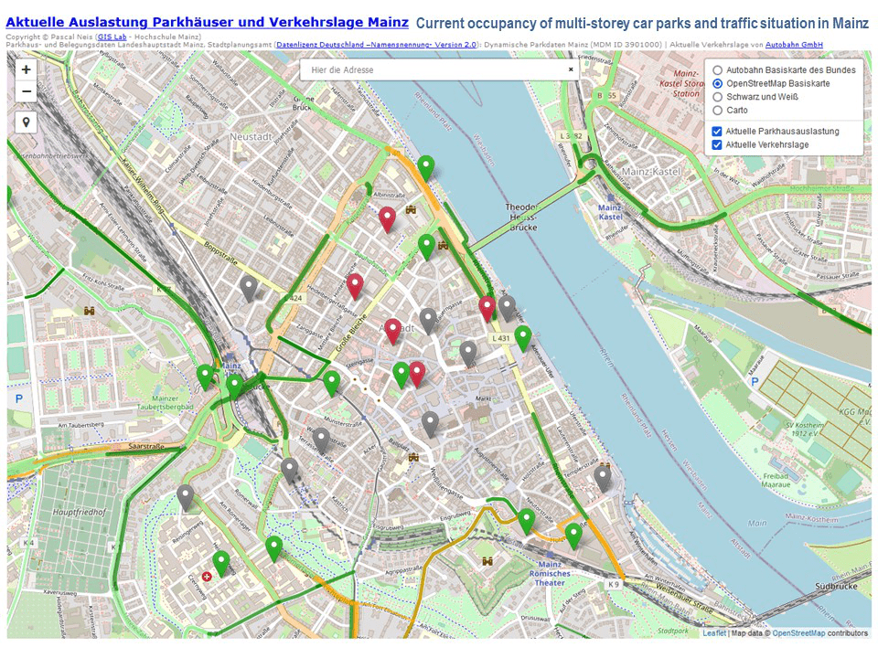
- Pascal Neis ukázal, jak lze zobrazovat užitečné živé informace s pomocí svobodných dat a svobodného software. Pro svou implementaci využití parkovacích garáží a dopravní situace v německém ‘Mainzu‘ , využívá také podkladovou mapu OSM.
Software
- Bryan Housel oznámil vydání verze 1.1.8 OSM editoru RapiD, která zahrnuje vylepšení výkonu i opravy chyb.
- Flatmap je nástroj pro generování vektorových dlaždic ve formátu Mapbox Vector Tiles pro zdroje geografických dat jako je OpenStreetMap. Vektorové dlaždice obsahují geometrie bodů, linií a polygonů, které pak využívají klienti jako MapLibre pro vykreslení uživatelsky definovaných map (demo).
Programování
- Overpass API nově zachází s uzavřenými cestami (ways) i jako s oblastmi.
Věděli jste …
- … o dostupnosti klíče
winter_service=*? Lze jej použít pro mapování cest nebo oblastí, které nejsou v zimě udržovány, stejně jako explicitní označení těch, které jsou udržovány pravidelně. - … o navigační aplikaci NUNAV Navigation? Ta kombinuje data OpenStreetMap s informacemi o aktuální dopravě pro Německo, Rakousko a Švýcarsko (aktuálně) a je dostupná v různých aplikačních obchodech v několika evropských zemích. Díky aktuálním informacím je tak možné neustále přepočítávat vaši trasu podle stavu dopravy. Aplikace neobsahuje reklamu ani sledování a lokační data z GPS jsou použita jen pro agregované informace o dopravě. Vyzkoušet si to můžete na webu kontrolního centra pro dopravu v Dolním Sasku.
- … že existuje seznam software pro uživatele OSM k využití doma nebo na cestách?
Ostatní geo záležitosti
- Firma Planet Labs, provozující satelitní snímkování Země, funguje již 10 let a v brzké době očekává vstup na burzu s evaluací asi 2,8 milionu dolarů. Ari Lewis nabízí přehled historie firmy ve vlákně na Twitteru.
- Carlo Ratti zjistil, že lidé (bez navigačního software) mají tendenci plánovat své trasy spíše podle intuice a zdaleka se neblíží nejefektivnějším možnostem. Pro studium tohoto vlivu bylo použito analýz dat z mobilních telefonů na MIT.
- Shaun McDonald zkoumal během instalace nového dálkového plynovodu přívětivost silniční sítě k cyklistům.
- TomTom popisuje, jak zlepšili kvalitu svého systému MapMetrics odstraněním chybných dat, například odfiltrováním GPS stop od lidí ve vlacích. Mapová data použitá při tomto procesu jsou postavená na OpenStreetMap.
Plánované události
| kde | co | Online | kdy | země |
|---|---|---|---|---|
| Черкаси | Open Mapathon: Digital Cherkasy | 24.10.–20.11.2021 | ua | |
| OSM Uganda Mapathon: Strengthening the OSM community | 30.10.2021 | |||
| Amsterdam | OSM Nederland maandelijkse bijeenkomst (online) | ✓ | 30.10.2021 |  |
| Bogotá | Resolvamos notas de Colombia creadas en OpenStreetMap | 30.10.2021 |  | |
| Prévessin-Moëns | Cartographie dans le Pays de Gex | 31.10.2021 |  | |
| OSMF Engineering Working Group meeting | 01.11.2021 | |||
| MapRoulette Community Meeting | 02.11.2021 | |||
| [Online] OpenStreetMap Foundation – Board of directors and advisory board public videomeeting | 02.11.2021 | |||
| Londýn | Missing Maps London Mapathon | 02.11.2021 |  | |
| Landau an der Isar | Virtuelles Niederbayern-Treffen | ✓ | 02.11.2021 |  |
| Stuttgart | Stuttgarter Stammtisch (Online) | 02.11.2021 | | |
| Bochum | OSM-Treffen Bochum (November) | 04.11.2021 | | |
| Bogotá | Resolvamos notas de Colombia creadas en OpenStreetMap | 06.11.2021 | | |
| OSM Local Chapters & Communities Virtual Congress | 06.11.2021 | |||
| Crowd2Map is 6! Join our party mapathon to learn more about our work.. | 07.11.2021 | |||
| 臺北市 | OSM x Wikidata Taipei #34 | 08.11.2021 |  | |
| Hamburk | Hamburger Mappertreffen | 09.11.2021 | | |
| Curych | OSM-Treffen Zürich | 11.11.2021 |  | |
| Berlín | 161. Berlin-Brandenburg OpenStreetMap Stammtisch | ✓ | 11.11.2021 | |
| FOSS4G State of the Map Oceania 2021 | 12.11.2021 | |||
| Missing Maps MonarchMappers Fall 2021 Mapathon | 13.11.2021 | |||
| Bogotá | Resolvamos notas de Colombia creadas en OpenStreetMap | 13.11.2021 | | |
| Geography 2050 Symposium – Mapathon for an Equitable Future | 13.11.2021 | |||
| Crowd2Map Tanzania GeoWeek Human Right’s Day FGM Mapathon | 15.11.2021 | |||
| Bonn | 145. Treffen des OSM-Stammtisches Bonn | 16.11.2021 | | |
| Berlín | OSM-Verkehrswende #29 (Online) | 16.11.2021 | | |
| Lüneburg | Lüneburger Mappertreffen (online) | 16.11.2021 | | |
| Missing Maps Arcadis Mapathon | 17.11.2021 | |||
| Missing Maps WMU Mapathon | 17.11.2021 | |||
| Kolín n. Rýnem | OSM-Stammtisch Köln | 17.11.2021 | | |
| Chambéry | Missing Maps CartONG Tour de France des Mapathons – Chambéry | 18.11.2021 | | |
| State of the Map Africa 2021 | 19.11.–21.11.2021 |
Poznámka: Pokud zde chcete vidět vaši akci
Toto číslo přeložil tom.k a redakčně upravili mkyral a YjM. Budeme velmi rádi, pokud podpoříte a oceníte naši práci tím, že budete dílo dále šířit, např. sdílením na sociálních sítích (like, retweet, boost…). Předem za to děkujeme.
Každé číslo v CZ verzi je promováno zde: @osmcz |
  @osmcz |
  Talk-cz | osm_sk |
  rss
rss
Můžete nás kontaktovat e-mailem:  weekly@openstreetmap.cz
Originál tohoto souhrnu připravili: Nordpfeil, PierZen, RCarlow, SK53, Sammyhawkrad, Strubbl, TheSwavu, arnalielsewhere, derFred.