07/12/2021-13/12/2021
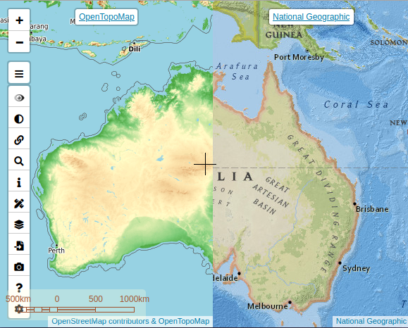
Multimap(a)s [1] | © Javier Jiménez Shaw | map data © OpenStreetMap contributors
Mapping
- TomTom has analysed OSM data in Sri Lanka, Nepal, Philippines, Taiwan and Vietnam. They have posted the areas identified for improvement on MapRoulette.
- indoor= updates their map data every hour. François2 described in his diary entry how map changes with respect to indoor tagging can be previewed without waiting for an hour.
- User TreeTracks (writing as LittleMaps) reviewed and analysed the high accuracy of OpenStreetMap’s road surface tags for sealed vs unsealed roads in Victoria, Australia.
- A tagging scheme has been proposed
 > to allow the passenger accessibility attributes from DELFI > to be translated into OSM mapping. The proposal has been developed by Nahverkehrsgesellschaft Baden-Württemberg (NVBW > ), OPENER next > — an mFund project to promote public transport accessibility for people with reduced mobility, and Mentz — a public transport software and service provider.
 - Mapper cytryn proposed > a unified tagging scheme for memorial benches in Poland.
- Florian Lainez has proposed > , on Talk-fr, creating a new ‘deprecated and unsupported’ status for tags and establishing a calendar to implement this deprecation. He also started to draft a proposal on the wiki.
- Voting is underway for the following proposals:
inlet=*for tagging the details of where the flow enters a culvert or pipeline, until Tuesday 28 December.amenity=parcel_machinefor mapping lockers that are used to store parcels awaiting self-service pick-up, until Wednesday 29 December.
 >
> 
 >
>  >
> Community
- ortho_is_hot, an Australian mapper, described their OSM process in 2021.
Imports
- Jacob (user safetygoggles) wants to import the buildings of Morris County, New Jersey, USA, from data provided by Morris County GIS, from whom he claims to have obtained permission for use in OpenStreetMap.
OpenStreetMap Foundation
- Heikki Vesanto has posted, on the OSM Foundation mailing list for discussion, suggestions for logos to use on the web map. This follows-up an earlier thread, as we reported earlier.
- The OSMF Board met Wednesday 15 December, by video conference, for the first time after the election. The topics discussed were:
- Election of officers
- Etiquette Guidelines
- Screen-to-screen/face-to-face board meetings in 2022
- Holiday circular blackout.
Minutes of the Board meeting have been published on the wiki.
- At last month’s advisory board meeting, Microsoft gave a presentation about allowing people, who are already logged into a Microsoft account, to improve OSM without logging in again to OpenStreetMap.
- Guillaume Rischard published the 2021 OSMF Treasurer’s report on the wiki.
- At last week’s OSMF Annual General Meeting a special resolution was passed by 357 votes to 28. This resolution allows the time spent as an associate member to count towards the qualification period required to be a board member.The 2021 Annual General Meeting wiki page reports in detail about the election and the AGM.
Education
- Dominik Weckmüller wrote a tutorial on how to create 3D OSM city models with QGIS and Aerialod. As an example, he published the result of Trier, the oldest town in Germany.
- The newest video in HOT’s YouTube playlist ‘HOT Training Webinar Series’ is for mappers who want to begin editing with JOSM.
- Maya Lovo wrote in her article, ‘Instead of consuming maps, let’s produce maps!’, on TeachOSM, about how Celeste Reynolds uses OpenStreetMap in the classroom. If teachers are doing similar projects with their students, they should contact Maya Lovo.
Maps
- Harry Wood has blogged a collection of interesting OSM-related maps from the #30DayMapChallenge.
- Hauke Stieler has made a QGIS project for an outdoor map based on OpenStreetMap data.
Open Data
- Gonéo has published > a blog post explaining how to integrate an open data dataset with OpenStreetMap.
Software
- The OSM BTC system, initiated by OsmAnd, has been adapted in order to increase the distribution among more active participants. Instead of calculating payments by changes (changesets), now changed objects in changesets are counted. Minimum number will be 300 per month.
- OsmAnd version 4.1 has been released for Android and iOS. The Android update includes support for Android Auto, disables the Mapillary layer plugin by default, and adds app shortcuts – for example, to quickly start a recording to upload tracks to OSM. The iOS update includes improved loading of maps.
- Vladimir Agafonkin has published an article entitled ‘Reimagining projections for the interactive maps era’.
Did you know …
- [1] … multimap(a)s Compare Map by Javier Jiménez Shaw ? The layers panel offers a large inventory of cartographic layers from around the world assembled by country and allows you to upload your own layers with various formats. A ‘Story Style Tutorial’ describes the functionalities available through the various buttons.
- … the Map Design Guide, from the State of Minnesota Interagency Map Accessibility Workgroup, which presents a number of best practices to ensure accessibility and usability, including styles and colours?
- … Marble, the online globe for Linux, Mac, Windows and Android with OSM maps?
Other “geo” things
- With the completion of the Kunming–Singapore railway central route on 3 December, Epic Maps tweeted a map showing the train trip you can now take from Singapore to Lagos, Portugal. Mashable has an article with more details about the journey.
- Anders Sundell, a political scientist at University of Gothenburg tweeted a map with all the soccer (football) fields in Europe, according to OpenStreetMap. In his analysis he stated: ‘There are more fields in Germany than anywhere else, but per capita, Liechtenstein wins’.
Upcoming Events
| Where | What | Online | When | Country |
|---|---|---|---|---|
| 京都市 | 幕末京都オープンデータソン#15:岩倉具視と岩倉村 | 2021-12-18 |  | |
| Lyon | Rencontre mensuelle Lyon | 2021-12-21 |  | |
| Bonn | 146. Treffen des OSM-Stammtisches Bonn | 2021-12-21 |  | |
| Lüneburg | Lüneburger Mappertreffen (online) | 2021-12-21 | | |
| 京都市 | 京都!街歩き!マッピングパーティ:第28回 智積院 | 2021-12-25 | | |
| Bremen | Bremer Mappertreffen (Online) | ✓ | 2021-12-27 | |
| Düsseldorf | Düsseldorfer OSM-Treffen (online) | 2021-12-29 | | |
| London | Missing Maps London Mapathon | 2022-01-04 |  | |
| Landau an der Isar | Virtuelles Niederbayern-Treffen | ✓ | 2022-01-04 | |
| Berlin | OSM-Verkehrswende #31 (Online) | 2022-01-04 | | |
| Stuttgart | Stuttgarter Stammtisch (Online) | 2022-01-04 | |
Note:
If you like to see your event here, please put it into the OSM calendar. Only data which is there, will appear in weeklyOSM.
This weeklyOSM was produced by MatthiasMatthias, PierZen, RicoElectrico, SK53, Strubbl, TheSwavu, cafeconleche, derFred.