2022/09/27-2022/10/03
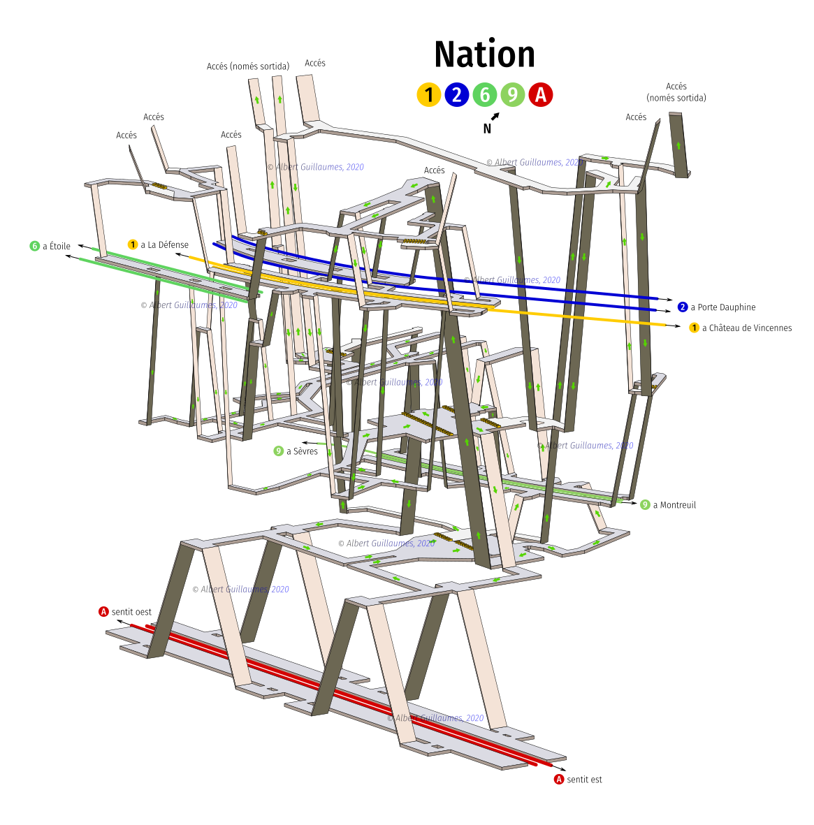
地下鉄をインドアマッピングしよう [1] | © Albert Guillaumes Marcer
マッピング
- Albert Guillaumes Marcerさんは、世界のいろんな地下鉄駅の構造をイラスト化しました。
- 以下のタグ提案でコメントを募集中です。
gender=*:施設を利用できる人のジェンダーを指定するタグ
- 以下のタグ提案で投票が実施されました。
- 貨物搬入施設の搬入口の大きさを指定するタグ。賛成多数で可決されました。
- JOSMで位置情報が付与されたJPG画像を背景に設定する方法をRobhubiさんが解説しています。
コミュニティ
- HeiGITはJavaでOSMデータを使ったルート検索サービスを構築するエンジニアを募集しています。
- Trufi協会は、公共交通機関のマッピングプロジェクトを支援するため、資金調達を担当する従業員を募集しています。
- OSMポンタルリエ地区(フランス)のTwitterアカウントは、フランス観光局がOSMデータを活用するよう勧めています。Antoine Richeさんは、セーニャンウー市(フランス)の観光局がマッピングプロジェクトを実施していることを紹介しました。
- 国連および欧州委員会は、OSMに関係した7つのチャレンジを開始しました。SDGsの達成度、OSMデータと外部データの統合利用などが目標として挙げられています。なお、チャレンジ項目のひとつに、週刊OSMをOSMウェブサイトで表示する案も挙げられています。もっとも成果を挙げたプロジェクトには1万ユーロが賞金として提供されます。
OpenStreetMap Foundation
- OpenStreetMap Foundation(OSMF)の第16回年次総会は、2022年12月10日土曜日16:00 UTCに、#osmf-gm IRCチャットルームで開催されます。この会議では、役員の選挙が行われます。三人が選任されます。取締役選挙の投票は、年次株主総会の1週間前に開始されます。
地方支部ニュース
- OpenStreetMap USは、9月のニュースレターをリリースしました。
イベント
地図
- Paul McBurney Jr. 氏は、小惑星衝突をシミュレートして、18世紀から現在までの地球との主要な既知の小惑星衝突の場所を特定するため、インタラクティブマップを作成しました。残念ながら、両方のマップともにOSMの著作権表示がありません。
- Maptiler研究所は、「ロード・オブ・ザ・リング」スタイルの世界地図を作成しました。
オープンデータ
- Martijn van Exel氏は、Rapidツールを使用してフリーソースとオープンソースのデータをOSMに追加する方法を説明しました。
ソフトウェア
- Goose Mapsチームは、Apple WatchプラットフォームでOSMベースのオフラインマップを構築するための詳細なストーリーを公開しました。
プログラミング
- Flo Edelmannさんは、Overpass QLクエリファイルのファイル拡張子を
*.overpassqlとして、標準化する作業を行っています。目標は、GitHubで適切な構文強調表示を可能にすることです。現在リストされていないリポジトリにそのようなファイルがあることを知っている場合は、彼に連絡してください。 - QwantMapsは、フランスのGoogle環境の代替として注目されています。現在
 ►は、自動車、徒歩、自転車に加えて、公共交通機関もナビゲーションのサービスに含まれています。OpenStreetMapをさまざまな用途に使用している一方で、表示している交通データは、多国籍企業であるKeolisの一部であるHoveとの協業から得られたものです。
 ►
►
リリース
ご存知でしたか?
- OSMの変更に関する統計を追跡できるダッシュボードをご存知でしたでしょうか?
- OpenInfraMap、OpenStreetMapベースの電力と通信インフラストラクチャマップをご存知?
- OSM Apps Catalogは、OpenStreetMap wikiに記載されているOSM Appsをフィルタリングおよび検索するためのWebサイトです。
メディア掲載
- Minds Behind Mapsは、OpenCageが後援した地理空間ポッドキャストであり、OpenStreetMapの創設者であるSteve Coastの独占インタビューを主催しました。
- OpenStreetMapはHackerNewsのフロントページで特集され、多くの議論を巻き起こしています。
- フィナンシャル・タイムズ はインタラクティブ・マップを公表し、北東部におけるウクライナの反撃を説明しています。
その他の “ジオ” な事柄
- OpenCageは、彼らの #geoweirdness 週間スレッドで、国境、国境紛争、排他についていくつかの興味深い事実を説明しています。
- 「ウェブベースの市民社会科学プロジェクト」であるColoring Londonは、ロンドンの建物に関する12のカテゴリーの情報を示す地図を公開しました。将来、他の都市に展開する計画もあります。
- GoogleはGoogle Mapsの新機能を発表しました。
- Channon Perryさんとそのボーイフレンドは、過去の「見逃した潜在的な運命の出会い」を見つけるために、二人の個人的なGPSトレースを分析しました。
- アマイツ・フェルナンデス氏は、ハリケーン・イアンがフロリダ州を襲った前後の照明の違いに着目しています。
まもなく開催
| 場所 | 名称 | Online | 開催日 | 国 |
|---|---|---|---|---|
| Hacktoberfest 2022 | 2022-10-01 – 2022-10-31 | |||
| United Nations – OSS4SDG: Smart Sustainable Cities Hackathon | 2022-10-03 – 2022-10-31 | |||
| Washington | MappingDC Mappy Hour | 2022-10-12 |  | |
| München | Münchner OSM-Treffen | 2022-10-11 |  | |
| San Jose | South Bay Map Night | ✓ | 2022-10-12 | |
| HOT Tasking Manager Monthly Meet Up | 2022-10-12 | |||
| Berlin | Missing Maps – DRK Online Mapathon | 2022-10-12 | | |
| Montrouge | Réunion des contributeurs de Montrouge et du Sud de Paris | 2022-10-13 |  | |
| Frankfurt am Main | Arbeitstreffen Indoor OSM 2022 | 2022-10-14 – 2022-10-16 | | |
| Berlin | 172. Berlin-Brandenburg OpenStreetMap Stammtisch | 2022-10-14 | | |
| Hlavní město Praha | World Railway Mapping Online Quarterly Meetup. | 2022-10-15 |  | |
| Guapimirim | Mapeamento da Cidade de Guapimirim – Rio de Janeiro (RJ) Brasil. | 2022-10-17 – 2022-10-18 |  | |
| Grenoble | Réunion mensuelle du groupe local OSM Grenoble | 2022-10-17 | | |
| Lyon | Rencontre mensuelle Lyon | 2022-10-18 | | |
| 156. Treffen des OSM-Stammtisches Bonn | 2022-10-18 | |||
| City of Nottingham | OSM East Midlands/Nottingham meetup (online) | ✓ | 2022-10-18 |  |
| Lüneburg | Lüneburger Mappertreffen (online) | 2022-10-18 | | |
| Sélestat | Rencontre des contributeurs.rices en Alsace | 2022-10-19 | | |
| Roma | Incontro dei mappatori romani e laziali – ottobre 2022 | 2022-10-19 |  | |
| Karlsruhe | Stammtisch Karlsruhe | 2022-10-19 | | |
| Zürich | Missing Maps Zürich Mapathon | 2022-10-19 |  | |
| Arlon | EPN d’Arlon – Atelier ouvert OpenStreetMap | 2022-10-20 |  | |
| Berlin | Berliner OSM Hackweekend | 2022-10-22 – 2022-10-23 | | |
| Rapperswil-Jona | OSM-Stammtisch | 2022-10-25 | | |
| San Jose | South Bay Map Night | ✓ | 2022-10-26 | |
| [Online] OpenStreetMap Foundation board of Directors – public videomeeting | 2022-10-27 | |||
| City of New York | New York City Meetup | 2022-10-29 | |
‘
Note: ここであなたのイベントを見たい場合は、カレンダーにそれを OSM Kalender 入れてください。そこにあるデータのみが、週刊 OSM に表示されます。 カレンダー 内で都市や国に言及するのを忘れないでください。
This weeklyOSM was produced by Lejun, Strubbl, TheSwavu, derFred, miurahr, muramototomoya, rtnf.