24.10.–30.10.2023
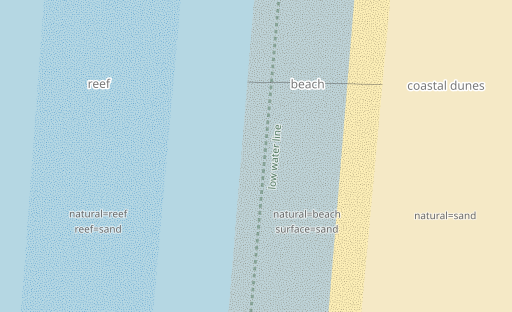
Některé tagy OpenStreetMap pro mapování pobřežních oblastí. [1] © Imagico.de
OSM CZ
- Informace o aktuálním stavu legalizace ČÚZK a oživení MTBMaps.
- Dotazy na fungování aplikace StreetComplete resp. jak se dostat na GitHub projektu?
- Možnost přidávání fotek skrze StreetComplete ne vyfocením, ale výběrem z galerie.
- Jak v Praze vyfiltrovat všechny světelné křižovatky?
OSM SK
- Vývoj kolem dálkové trasy Via Slovakia.
- Jaký je doporučený postup při vytváření adres – budova nebo samostatný bod?
Důležité zprávy
- Přes 30 000 lidí bylo nuceno opustit své domovy kvůli záplavám v ghanské oblasti North Tongu. Stephen Mawutor Donkor žádá na mail listu o pomoc s mapováním tohoto postiženého regionu.
O nás
- Pět let týdeníku WeeklyOSM v portugalštině! Je to pět let, co jsme začali tohle dobrodružství překladů a revizí článků v portugalštině s WeeklyOSM 431 a nyní jsme dosáhli 262 čísel bez přerušení! Doufáme, že jste si i vy naši práci užili! WeeklyOSM může být mnohem bohatší, pokud každý z portugalsky mluvící komunity bude sdílet nějaký článek. Víte, že i vy můžete přispět? Zjistěte jak. Editoři WeeklyOSM pro portugalštinu Elizabete Oliveira a Nuno Azevedo posílají své vřelé pozdravy z Azor.
Mapování
- [1] Christoph Hormann vysvětluje základy mapování pobřežní geografie v OpenStreetMap.
- Vincent de Château-Thierry oznámil
 na platformě Mastodon, že soubor nahrazující FANTOIR ► je konečně francouzskými úřady dán k dispozici. To umožní aktualizovat obsah BANO ► a vylepšit mapování ulic v ve francouzském nástroji Pifomètre . Pifomètre dovoluje srovnávání dat OSM a FANTOIR zobrazením seznamu shod a rozporů podle jednotlivých obcí.
 - Ilya Zverev vysvětluje ► některé tagy OpenStreetMap potřebné pro mapování pěšin.
- Návrh na tagování
crossing:continuouspro označení zda chodník, cyklostezka nebo podobné pokračují bez přerušení přes silnici očekává vaše komentáře.
 na platformě Mastodon, že soubor nahrazující
 ►
►Komunita
- 38446 píše ve svém deníku o cestování veřejnou hromadnou dopravou a ptá se, jestli někdo umí vykreslit tag
intervalv mapách postavených na OpenStreetMap. - Nombuso a Ibrahim Kamara blogují o mapování zdravotnických dat eSwatini v rámci projektu komunity otevřeného humanitárního mapování v pracovní skupině mentoringu.
Nadace OpenStreetMap
- Microsoft věnoval Nadaci OpenStreetMap dar ve výši 150 000 dolarů. Peníze by měly být využity na zlepšení a údržbu infrastruktury OSM a také lokálních, regionálních i globálních aktivit komunit OSM.
Události
- Topi Tyukanov publikoval úkoly pro výzvu #30DayMapChallenge 2023.
- Finský Geomob se bude konat ve čtvrtek 9. listopadu ve městě Oulu.
- Byl zveřejněn program konference SotM EU.
- Konference SotM Africa se bude konat v termínu od 30. listopadu do 2. prosince v kamerunském Yaounde. Jsou dostupné informace o možnostech pro sponzory.
- umbraosmbr ve svém deníku zveřejnil příspěvky a prezentace z konference SotM Brasil 2023, které laskavě poskytli jejich autoři.
 příspěvky a
 Mapy
- GeoObserver použil Datawrapper pro rychlou a jednoduchou tvorbu uživatelské mapové vizualizace.
 Datawrapper pro rychlou a jednoduchou tvorbu uživatelské mapové
 OSM v akci
- Podle statistik nehod Úřadu pro sociální pojištění v zemědělství a lesnictví (SVLFG) jsou lesní práce jednou z nejnebezpečnějších profesí v Německu. Pro jednodušší práci záchranných složek při vyhledávání lidí potřebujících pomoc zveřejnila firma Intend GmbH datovou sadu KWF ► (Rada pro lesní práce a lesnické technologie) v aplikaci Hilfe im Wald (pomoc v lese). Ta používá OpenStreetMap pro podkladové mapy a existující body záchrany .
V roce 2014 německá komunita pracovala► na týdenním úkolu ► (pro „CraftMapper“). Přestože data KWF jsou pod otevřenou licencí, podle informací z KWF je nelze z licenčních důvodů přidat ► do OSM. - Výzkumný tým z University ve Freiburgu vytvořil globální mapu dopravy (tramvaje, metra, rychlodráhy, vlaky) využívající data OpenStreetMap zpracovaná s pomocí algoritmu LOOM (Line-Ordering Optimised Maps) .
- Gislars komentuje jeden z projektů, na kterém se pracovalo v rámci akce OpenStreetMap Hackweekend Berlin 2023: obstbaumkarte.de (mapa ovocných stromů). Při najetí na strom na mapě se vám o něm zobrazí detailní informace.
Software
- daniel-j-h sdílí svou zkušenosti z vytváření vektorových map s pomocí nástrojů Maplibre a Protomaps.
Programování
- Mikhail Sarafanov ukazuje ► využití knihovny v jazyce Python estaty pro analýzu dostupnosti ve městech.
- Rtnf zjistil, že na data OpenStreetMap se lze dotazovat s pomocí systému QLever SPARQL.
- Igor Sukhorukov pokračuje v demonstracích aplikací svého nástroje OpenStreetMap H3 a tentokrát ukazuje ►, jak jej použít společně s nástrojem Graphhopper pro zjištění dostupnosti a atraktivnosti bydlení pro chodce.
Nová vydání
- OpenRailwayMap oznámili několik vylepšení svého vyhledávání. Plná dokumentace k API pro tento prvek je k dispozici na GitHubu.
Věděli jste …
- … že můžete pomoci vylepšit linie pobřeží nebo administrativní hranice v OpenStreetMap využitím aplikace OSM NightWatch? Zdrojový kód pro tuto aplikaci je dostupný na GitHubu.
- … že tag
opening_hoursje opravdu velmi komplikovaný? Můžete nicméně použít aplikaci otvírací hodiny – Web na OSM pro automatické generování tagu z URL nebo volného textu. - … že MapComplete nyní nabízí vrstvu uměleckých děl? Data jsou získávána v reálném čase s pomocí Overpass nebo OSM API a můžete nová data do OSM skrze tuto aplikaci i přidávat.
Ostatní geo záležitosti
- Některé zeměpisné souřadnice na Zemi jsou přezdívány „póly nedostupnosti“, protože se jedná o nejvíce vzdálené body v rámci nějaké hranice. Jedním z nich je Bod Nemo, ležící v jižním Tichém oceánu, který je nejvzdálenější od jakéhokoliv pobřeží.
- Nicolas Lambert vysvětluje, proč nemůže přidat ukazatele měřítka k mapám světa.
Plánované události
| kde | co | online | kdy | země |
|---|---|---|---|---|
| Thrissur | OSM Kerala Annual Community Meetup 2023 | 03.11.–04.11.2023 |  | |
| Dublin | OpenStreetMap Ireland AGM | 04.11.2023 |  | |
| Budapešť | Picnic in Csörsz park to meet your local mappers | 06.11.2023 |  | |
| Accra | Ghana YouthMappers Showcase online | 06.11.–10.11.2023 |  | |
| Missing Maps London Mapathon | 07.11.2023 | |||
| San Jose | South Bay Map Night | ✓ | 08.11.2023 |  |
| Berlín | OSM-Verkehrswende #53 | ✓ | 07.11.2023 |  |
| Recife | workshop Starting Collaborative Mapping with the ID Editor. / Iniciando o Mapeamento Colaborativo com o Editor ID | 08.11.–09.11.2023 |  | |
| okrsek Lorain | OpenStreetMap Midwest Meetup | ✓ | 09.11.2023 | |
| Mnichov | Münchner OSM-Treffen | 08.11.2023 | | |
| Capanema | Oficina Openstreetmap Iniciando no Mapeamento Colaborativo com o Editor ID. | 08.11.–09.11.2023 | | |
| Berlín | 185. Berlin-Brandenburg OpenStreetMap Stammtisch (Online) | ✓ | 09.11.2023 | |
| Berchem | State of the Map EU 2023 | 10.11.–12.11.2023 |  | |
| Brno | Listopadový brněnský Missing Maps mapathon na konferenci OpenAlt 2023 | 11.11.2023 |  | |
| Kodaň | 12.11.2023 |  | ||
| Hannover | OSM-Stammtisch Hannover | 12.11.2023 | | |
| HOT Disaster Mapathon: OSM GeoWeek | 13.11.2023 | |||
| Chambéry | Mapathon débutant saison 23/24 CartONG | 13.11.2023 |  | |
| 臺北市 | OpenStreetMap x Wikidata 月聚會 #58 | 13.11.2023 |  | |
| Berlín | Missing Maps – MSF & DRK Online Mapathon | 14.11.2023 | | |
| OSMF Engineering Working Group meeting | 15.11.2023 | |||
| Salt Lake City | Salt Lake City Monthly Map Night | 16.11.2023 | | |
| แขวงพระบรมมหาราชวัง | SOTM Asia | 15.11.–17.11.2023 | th | |
| Bochum | Bochumer OpenStreetMap-Treffen | 16.11.2023 | | |
| 종로1·2·3·4가동 | 2023 국경없는의사회 지오위크 매파톤 | ✓ | 16.11.2023 |  |
| Rio de Janeiro | GIS DAY – HUB YouthMappers Rio de Janeiro (Brazil) | 17.11.2023 | | |
| Pforzheim | ÖPNV-Mapathon beim Verkehrsverbund Pforzheim-Enzkreis | 18.11.2023 | |
Poznámka: Pokud zde chcete vidět vaši akci
Návrhy na zajímavé odkazy pro příští čísla nám můžete poslat zde a podělit se tak o ně s našimi čtenáři.
Toto číslo přeložil tom.k a redakčně upravil mkyral. Budeme velmi rádi, pokud podpoříte a oceníte naši práci tím, že budete dílo dále šířit, např. sdílením na sociálních sítích (like, retweet, boost…). Předem za to děkujeme.
Každé číslo v CZ verzi je promováno zde: @osmcz |
  @osmcz |
  Talk-cz | osm_sk |
  rss
rss
Můžete nás kontaktovat e-mailem:  weekly@openstreetmap.cz
Originál tohoto souhrnu připravili: Elizabete, MatthiasMatthias, Strubbl, TheSwavu, TrickyFoxy, barefootstache, derFred, renecha.