02/01/2024-08/01/2024
Eclipse Map [1] | Copyright © Time and Date AS | map data © OpenStreetMap contributors
Mapping
- Using Pascal Neis’ website OSM-notes, Vitor George has created the application ‘Oldest OSM Notes by Country’ to find the oldest notes per country and to help fix them in a meaningful way.
- Brian Sperlongano, aka ZeLonewolf, presented his Wikidata data quality assurance script, which detects issues with US administrative boundaries by comparing them with Wikidata and US Census Bureau data. The tool checks boundaries with
admin_levelvalues 7–9 and CDPs withboundary=census. The results are updated daily and are sorted by state. The author is looking for feedback and corrections for the tool. He pointed out that some of the problems may be Wikidata-related. - Requests for comments have been made on these proposals:
toilets:menstrual_productsfor adding information about whether a toilet has menstrual products available or not.highway=cyclistto indicate that a road or street is mainly or exclusively for cycle traffic.
- Voting on
emergency=disaster_response, for consistent worldwide tagging of disaster response service stations providing emergency response for civilians during or after a disaster, is open until Thursday 18 January.
Community
- Alper shared how he is mapping the paths of unknown parts of a forest with high definition GNSS and Manjaro Linux running on his tablet. He used QGIS’s GPS live tracking feature to record data directly from his GNSS receiver.
- Justo Gómez Vaello, a Geomatics and Surveying Engineer from Spain, is the UN Mapper of the Month for January 2024.
- The very active OSM community in Fukushima discusses
 each issue of the Japanese version of weeklyOSM online. They then publish this discussion on YouTube. Recommended for imitation.
 each issue of the Japanese version of weeklyOSM online. They then publish this discussion on YouTube. Recommended for imitation.
OpenStreetMap Foundation
- The OSMF Operations Working Group announced on 10 January that OpenStreetMap had discontinued the Facebook login feature following some new requirements. The working group was able to fix the access problem a few days later. The approximately five hundred thousand OpenStreetMap user accounts affected by the shutdown could have still accessed their accounts by using the password reset feature.
- The OSMF virtual event Local Chapters and Communities Congress 2024 (#LCCC24) now has a date: Saturday 2 March 13:00 UTC to 16:00 UTC. More information can be found on the OSM Wiki.
Local chapter news
- Minh Nguyễn has compiled an excellent resource on the recently updated Manual of Uniform Traffic Control Devices for Streets and Highways (MUTCD), the governing guide for traffic signs in the United States.
- FOSSGIS e.V. has welcomed ► the new year and provided a review and outlook of the organisation’s work.
- Sawan Shariar announced the important dates for the OSM Bangladesh Election 2024, with the election happening on Friday 26 January. Additionally, he gave an overview of the election process, how to nominate a candidate, and how to get involved.
- The 20th anniversary of OpenStreetMap will be celebrated at the State of the Map Europe 2024. OpenStreetMap Poland has the honour of hosting this event, which will be held in Łódź on 18 to 21 July. Volunteers are needed to help organise and run this conference.
 ►
►
Events
- The FOSSGIS Conference 2024 ► will take place in Hamburg on 20 to 23 March. Registration ► is currently open ►. An ‘unconference’, to be held on OSM Saturday, is being organised ► via the wiki. Helping hands are needed ► for the organisation of the conference.
- Shravan has invited you to the ‘End of Winter Editing Party’, which will be held at TomTom’s HQ on De Ruijterkade 154, in Amsterdam on Thursday 1 February.
OSM research
- A study has revealed that human infrastructure is increasingly encroaching on sandy coasts worldwide, with significant portions of these areas having less than 100 metres of infrastructure-free space, posing serious risks to ecosystem services, and necessitating the integration of nature protection into spatial planning policies.
- Pamela Lattanzi et al. have conducted a fishing zone participatory mapping project in small-scale fisheries of the Campania region of Italy. The mapping was done by printing OpenStreetMap map tiles with additional features such as bathymetry contour lines, on A4 paper at 1:100,000 and 1:250,000 scales.
- This study introduced the MERIT-Plus dataset, enhancing the original MERIT river network by delineating endorheic and exorheic drainage basins, enabling more accurate hydrological modeling, and improved understanding of global and regional water balances, especially in endorheic regions using vector polygons from OpenStreetMap.
- J. Rafael Verduzco Torrest and David Philip McArthur analysed the public transport accessibility indicators for urban and regional services in Great Britain. This analysis was conducted using OpenStreetMap road and pedestrian network data.
- Wanwan Li utilised data from OpenStreetMap to develop a realistic virtual world synthesising technique.
Humanitarian OSM
- Ann-Jinette Hess reported in the BORGEN Magazine about the Missing Maps Project and how to participate.
Maps
- Mark Stosberg has created a report about the most dangerous intersections for pedestrians in Bloomington, Indiana, where he relied on OpenStreetMap data.
OSM in action
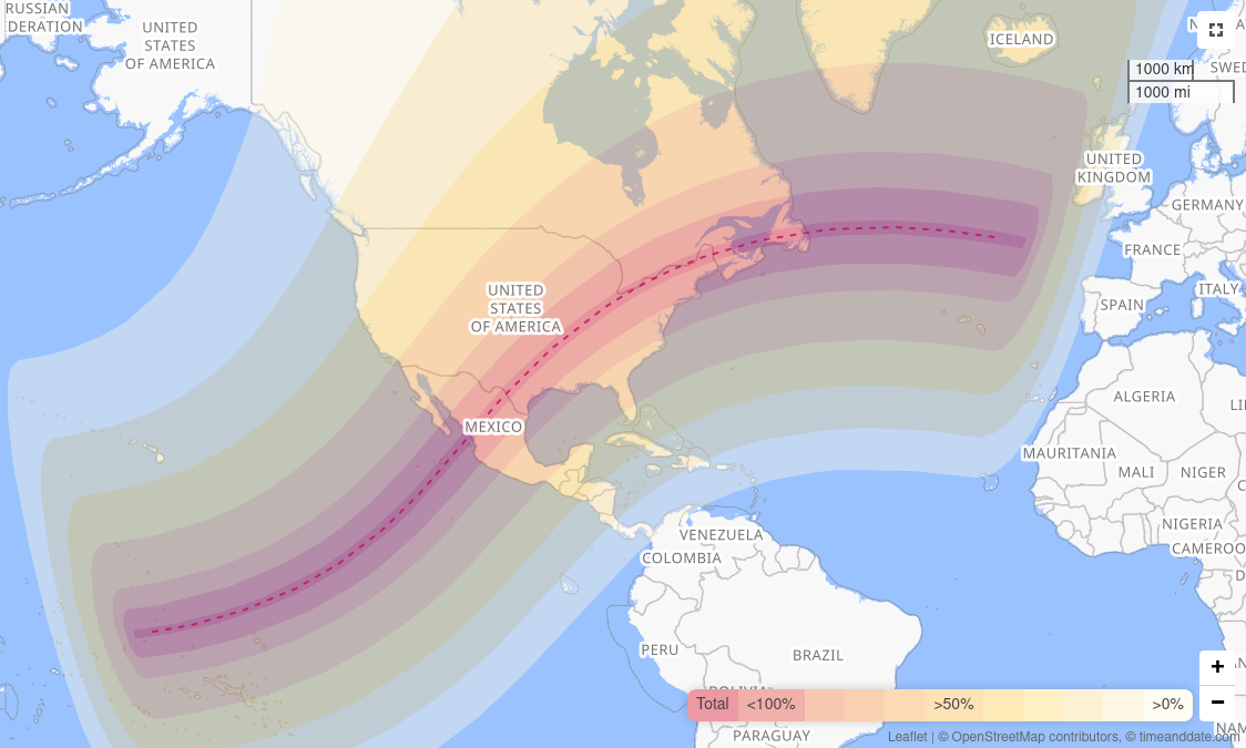
- [1] These two OpenStreetMap-based maps show the path of the total solar eclipse happening on Friday 8 March. It will cross North America from Mexico’s Pacific coast to Canada’s Atlantic coast:
Hopefully there will be clear skies to (cautiously) observe the eclipse.
- Cycling Weekly discussed the challenges cyclists face with satnav route planning.
- Mastodon Near Me is a uMap showing many global Mastodon servers by country and region. The list is maintained by Jaz.
- ECF’s (European Cyclists’ Federation) report on cycling infrastructure used OpenStreetMap as the map background.
- utzer has used uMap and OpenStreetMap to create their own personalised itinerary map.
- GPS-tour.info is a website that offers tracks for various outdoor activities. Users can search for tours, upload their own tracks, and share their experiences. The website is based on OpenStreetMap.
Open Data
- The SEMIC community has published guidelines on how to use DCAT-AP for High-Value Datasets, on GitHub. The DCAT Application profile for data portals in Europe (DCAT-AP) is a specification based on the Data Catalogue vocabulary (DCAT) for describing public sector datasets in Europe.
- The FOKUS (Fraunhofer Institute for Open Communication Systems) is offering ► an ‘Open Data Literacy’ course. This free course is online, can be customised, and teaches the basics of managing open data and metadata.
Software
- Organic Maps distributed through the Google Play store has temporarily made login via OSM accounts unavailable due to Google’s restrictions. The developer mentioned this on GitHub. It is not yet clear whether this issue will affect other mobile applications that can log in via OSM accounts for editing.
- The GeoServer roadmap for 2024 is focusing on improving performance, supporting new data formats and data sources, and expanding functionality for the analysis and visualisation of geodata.
- Harald Hetzner has released a JOSM plugin for displaying local terrain elevation, elevation contour lines, and hillshade based on SRTM data.
- Harald Hetzner has released another JOSM plugin for opening all the GPX tracks in the current map view from a specified directory.
- In his diary, Jiri Vlasak summarised the functionality and scope of the project, the work done in 2023, and the upcoming work for 2024 for Divide and map. Now. ‘the damn project’ helps mappers to divide a big area into smaller squares, so that people can map together.
- Organic Maps version 2024.01.09-5 has been released. In this version, support for Android Auto has entered the public preview stage.
Programming
- Dustin Carlino wrote about his December walking-focused project where he’s developing a crossing tool (Severance Snape), which visualises places where a pedestrian naturally wants to cross on some ‘desire line’, but can’t and has to take a detour.
- Robert Riemann published his project Jekyll MapLibre, which is able to display OpenStreetMap-based maps using MapLibre GL JS in Jekyll.
Releases
- zyphlar has published a collection of stickers and posters for Organic Maps on GitHub.
Did you know …
- … the satellite navigator osmin for Android and Linux devices?
- … the GNOME desktop map application Maps, which is based on OpenStreetMap?
- … Haptické Mapy.cz from Blind Friendly Maps and Touch Mapper? This service supports the creation of tactile maps for the blind. You can print them out yourself or, if you live in Europe, have them printed for you.
- … about the various websites that can show you an animation of public transport systems around the world?
- TRAVIC – Transit Visualisation Client: Uses static timetable data from various sources.
- Swiss Railway Network: Uses timetable data from Swiss Federal Railways (SBB), complete with animated train movements.
- Mini Tokyo 3D: Uses data from Public Transportation Open Data Center, Japan (公共交通オープンデータセンター ), complete with 3D train movement animation.
- Treinposities.nl: Shows train movements around Netherlands using data from NDOV, iRail, and NS API.
- Carto GRAOU: Using data from SNCF Réseau, France.
- rasp.yandex.ru: Displays train and bus data in Russia.
- Spacing out with train: Uses data from Korea Transport Database (KTDB), showing 3D train animation like Mini Tokyo 3D above.
- … the Wikidata SPARQL example queries showing how to link Wikidata with OpenStreetMap by using the OSM Sophox service?
OSM in the media
- The Drive talked about Curvature. Curvature is a programme that analyses the geometry of OSM roads and generates a map of the most twisty roads, colour-coded by how many curves they have.
- Eric van Rees wrote, in Geo Week News, about Marc Prioleau’s views on the possible ways Overture and OpenStreetMap could collaborate.
Other “geo” things
- Google developed the ‘Flood Forecasting Initiative’, an AI-based system to report and predict riverine flood disasters.
- Jack-bo1220 has compiled a list of papers, datasets, codes, and pre-trained weights related to remote sensing foundation models.
- The Japan Aerospace Exploration Agency (JAXA) has released several satellite photos showing the emergence of new coastal land after the Noto Peninsula earthquake on 1 January.
- Pia Volk has written ► Deutschlands verschwundene Orte (Germany’s lost places), which is about the history of thirty now-invisible historic locations in Germany, ranging from Bronze Age settlements to symbolic buildings removed for political reasons.
- TomTom and Microsoft are planning to develop an AI-based conversational automotive assistant.
- TomTom has presented their new ‘Orbis Maps’, a map based on the standard specification of the Overture Maps Foundation. The map is currently available through an early access process.
Upcoming Events
| Where | What | Online | When | Country |
|---|---|---|---|---|
| Lorain County | OpenStreetMap Midwest Meetup | ✓ | 2024-01-11 |  |
| Berlin | 187. Berlin-Brandenburg OpenStreetMap Stammtisch | 2024-01-11 |  | |
| Zürich | OSM-Stammtisch Zürich | 2024-01-11 |  | |
| Bochum | OSM-Stammtisch Bochum | 2024-01-11 | | |
| Ustaritz | Journée OSM Pays Basque Sud Landes | 2024-01-13 |  | |
| Hannover | OSM-Stammtisch Hannover | 2024-01-13 | | |
| København | OSMmapperCPH | 2024-01-14 |  | |
| Niort | Rencontre OSM Poitou à Niort (79) | 2024-01-14 | | |
| Hilversum | OSGeo.nl OSM-NL QGIS-NL New Year’s Party | 2024-01-14 |  | |
| Budapest | OSM Hungary Meetup | 2024-01-15 |  | |
| Grenoble | Réunion du groupe local de Grenoble | 2024-01-15 | | |
| Lyon | Réunion du groupe local de Lyon | 2024-01-16 | | |
| City of Edinburgh | OSM Edinburgh pub meetup | 2024-01-16 |  | |
| Lüneburg | Lüneburger Mappertreffen | ✓ | 2024-01-16 | |
| Map-py Wednesday | 2024-01-17 | |||
| Karlsruhe | Stammtisch Karlsruhe | 2024-01-17 | | |
| Gent | OpenStreetMap meetup & MapComplete workshop at TomTom | 2024-01-18 |  | |
| Washington | Mapping USA | ✓ | 2024-01-19 – 2024-01-20 | |
| Bengaluru | OSM Bengaluru Mapping Party | 2024-01-20 |  | |
| City of Fremantle | Social Mapping Saturday: Fremantle 2024 | 2024-01-20 |  | |
| Hai Buluk | OSM Africa Monthly Mapathon: Map South Sudan | ✓ | 2024-01-20 | ss |
| Bremen | Bremer Mappertreffen | 2024-01-22 | | |
| San Jose | South Bay Map Night | ✓ | 2024-01-24 | |
| iD Community Chat | 2024-01-24 | |||
| OSMF Engineering Working Group meeting | 2024-01-24 | |||
| London Borough of Islington | Geomob London | 2024-01-24 | | |
| Lübeck | 138. OSM-Stammtisch für Lübeck und Umgebung | 2024-01-25 | | |
| Wien | 70. Wiener OSM-Stammtisch | 2024-01-25 |  |
Note:
If you like to see your event here, please put it into the OSM calendar. Only data which is there, will appear in weeklyOSM.
This weeklyOSM was produced by LuxuryCoop, PierZen, SeverinGeo, Strubbl, TheSwavu, barefootstache, derFred, mcliquid, renecha, rtnf.
We welcome link suggestions for the next issue via this form and look forward to your contributions.
Note that the big eclipse is April 8th, not March 8th.