03/10/2024-09/10/2024
OpenInfraMap on a globe [1] | Map data © OpenStreetMap contributors
About us
- The editorial board of weeklyOSM is celebrating ten years of sharing weekly news from the OpenStreetMap world in multiple languages. On October 2014, the first multilingual edition was published.
Mapping
- Okainov has made a request for comments on their new proposal to standardise the mapping of airport lounges.
Community
- Kingsley shared his experience of attending the State of the Map 2024 in Nairobi, Kenya.
- The OpenStreetMap Community forum is now faster. The site has received a hardware upgrade.
- Raquel Dezidério wrote
 ►, in her diary about the 10-year anniversary of the multilingual edition of the Wochennotiz (weeklyOSM), including a link to an interview with the founders. She also gave thanks for the opportunity to be part of the team of editors for Brazilian Portuguese, along with Lívia Rios and Adriele Bernardo.
 ►
►
OpenStreetMap Foundation
- Grant Slater, the Senior Site Reliability Engineer at the OpenStreetMap Foundation, published a report outlining the progress of OSM’s infrastructure during 2023–2024.
Local chapter news
- [1] Jochen Topf announced ► the launch of the newly redesigned website for the German OpenStreetMap community.
 ►
►Events
- The FOSSGIS conference will be held 26 to 29 March 2025, at the Schloss Münster (we reported earlier). The call for participation has been made ►, and submissions will be accepted ► until Tuesday 5 November. You can also support this event by becoming a sponsor. For more information regarding sponsorship please check the sponsorship brochure.
- Michael Reichert has published ► a report on the OpenStreetMap booth at the Maker Faire in Hannover, Germany, held on 17 and 18 August.
- Matt Whilden announced that the next State of the Map US will be held in Boston from 19 to 21 June 2025.
Education
- Amy Plant showed in a video how to find a place from a photo using OSM, overpass turbo, and F4map.
- Panagiotis Vasilopoulos tooted that they have written a blog on how to import OSM data into Blender.
 in a video how to find a place from a photo using OSM, overpass turbo, and F4map.
Maps
- The OK Lab Flensburg has downloaded data from the Open Data Portal and turned it into an interactive heritage protection map ►. The current state of development can be viewed on GitHub and the software can be deployed by any municipality, city, or state free of charge and licence-free.
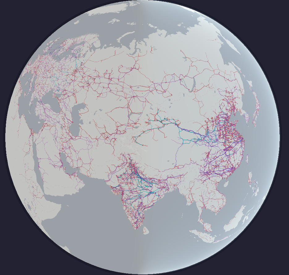
- OpenInfraMap is now rendered as a 3D globe with zooming and panning capabilities, using the recently released MapLibre GL v5 pre-release. The water layer has also been updated to display reservoirs, water treatment and sewerage plants, and pumping stations.
- Netherlands’ National Road Traffic Data Portal has published an interactive map that shows the location of and detailed information about traffic signs.
 map that shows the location of and detailed information about traffic signs.
OSM in action
- Flickr recently added a map feature to their Flickr Commons Explorer. It showcases historical photographs from cultural institutions all around the world using an OpenStreetMap-based interactive map.
- The EU Commission has made the free WiFi4EU app available, which is intended to make it easier to find free Wi-Fi hotspots. The app uses an OpenStreetMap map, but unfortunately without attribution.
Software
- PLATEAU is a 3D urban model development, utilisation, and open data project led by Japan’s Ministry of Land, Infrastructure, Transport, and Tourism.
- GeoScribbles is now available in iD editor as an overlay layer.
- A new Panoramax instance for MapComplete is now available.
- Jefle released ‘Public Transport Stop Analysis’, an interactive map visualising public transport stop data from the OSM database.
- Richard Ulmer has developed ‘osmar’, a command line tool for directly querying OSM data from PBF files.
Releases
- Michal announced the release of Locus Map 4.26, which includes several enhancements, such as improvements to the rotating map feature, offline routing engine, remaining elevation estimation, and the Garmin smartwatch add-on.
Did you know …
- … that Organic Maps now offers native track recording ?
- .. that the United Nations Vector Tile Toolkit is a collection of open source software to produce, host, style, and optimise vector tiles for web mapping?
Other “geo” things
- The Kon-Tiki team has published ► a statistical report about the age of houses in 80 large cities in Russia. They divided the age of buildings into several historical periods: Pre-Revolutionary (up to 1917), Avant-Garde (1918 to 1929), 1930s (1930 to 1939), Military and Post-War (1940 to 1956), Khrushchyovka (1957 to 1964), Era of stagnation (1865 to 1985), Post-Perestroika (1991 to 1999), 2000s (2000 to 2009), and 2010s (2010 to 2020).
- InsertUser noticed that osmhydrant was briefly referenced in the recent Phil Edwards video essay titled ‘The Secret Economics of Google Street View’.
- Anton Thomas will be giving a talk, ‘Wild World: A Hand-Drawn Map Odyssey’, at Stanford University on Monday 11 November. Anton will dive deep into his story, from the endless details of Wild World to managing its popularity, and the psychological odyssey of three years drawing one map, to his search for new ideas in the Kenyan wilderness. The event is free and hybrid.
 ►
►Upcoming Events
| Where | What | Online | When | Country |
|---|---|---|---|---|
| Zámoly | Zámoly Mapping Party | 2024-10-12 |  | |
| København | OSMmapperCPH | 2024-10-13 |  | |
| Grenoble | Atelier d’octobre du groupe local de Grenoble | 2024-10-14 |  | |
| Missing Maps London: (Online) Mid-Month Mapathon [eng] | 2024-10-15 | |||
| Lyon | Réunion du groupe local de Lyon | 2024-10-15 | | |
| San Jose | South Bay Map Night | ✓ | 2024-10-16 |  |
| Bonn | 181. OSM-Stammtisch Bonn | 2024-10-15 |  | |
| Flensburg | OK Lab Flensburg Community OSM Treffen | 2024-10-16 | | |
| Salt Lake City | OSM Utah Monthly Map Night | 2024-10-17 | | |
| Karlsruhe | Stammtisch Karlsruhe | 2024-10-16 | | |
| Atelier Pifomètre/Bano | 2024-10-16 | |||
| Bruxelles – Brussel | Velopark mapathon @ Fietsberaad offices | 2024-10-17 |  | |
| Zagreb | OSM-HR Meetup | 2024-10-17 |  | |
| Boucau | Rencontre Mapadour (Groupe local Pays Basque – Sud Landes) | 2024-10-18 | | |
| Hannover | OSM-Stammtisch Hannover | 2024-10-18 | | |
| Rouen | Atelier découverte OpenStreetMap | 2024-10-18 | | |
| Pamplona/Iruña | GeoCamp ES | 2024-10-19 |  | |
| Karlsruhe | Karlsruhe Hack Weekend October 2024 | 2024-10-19 – 2024-10-20 | | |
| Yelahanka taluku | OSM Bengaluru Mapping Party | 2024-10-19 |  | |
| Cabecera Municipal Duitama | Estado del Mapa – Duitama 2024 | 2024-10-19 |  | |
| Nonnweiler | Craftmapping Höckerlinie Otzenhausen | 2024-10-19 | | |
| Kalyani Nagar | OSM Mapping Party at TomTom | 2024-10-19 | | |
| Toulouse | Rencontre du groupe local de Toulouse | 2024-10-19 | | |
| [Online] 18th Annual General Meeting of the OpenStreetMap Foundation | 2024-10-19 | |||
| Amsterdam | A Synesthete’s Atlas: Cartographic Improvisations Between Eric Theise and Edward Schocker | 2024-10-19 |  | |
| Mumbai | Mumbai Online Remote Mapping Pre-Party | 2024-10-20 | | |
| Berlin | DRK & HeiGIT Online Beginner Mapathon | 2024-10-22 | | |
| City of Edinburgh | OSM Edinburgh pub meetup | 2024-10-22 |  | |
| Berlin | OSM-Verkehrswende #63 | ✓ | 2024-10-22 | |
| Lübeck | 147. OSM-Stammtisch Lübeck und Umgebung | 2024-10-24 | | |
| OSMF Engineering Working Group meeting | 2024-10-25 | |||
| Bologna | OpenStreetMap al Linux Day di Bologna | 2024-10-26 |  | |
| 中正區 | 台北城內商家mapping party暨慶賀MozTW 3.0喬遷之喜 | 2024-10-26 |  | |
| Mumbai | Mumbai Mapping Party | 2024-10-26 | | |
| City of South Perth | Social Mapping Sunday: Perth Zoo FREE TICKETS | 2024-10-27 |  | |
| Bremer Mappertreffen | 2024-10-28 | |||
| Saint-Étienne | Rencontre Saint-Étienne et sud Loire | 2024-10-28 | |
Note:
If you like to see your event here, please put it into the OSM calendar. Only data which is there, will appear in weeklyOSM.
This weeklyOSM was produced by Raquel Dezidério Souto, Strubbl, TheSwavu, YoViajo, barefootstache, derFred, rtnf.
We welcome link suggestions for the next issue via this form and look forward to your contributions.