22.08.–28.08.2024
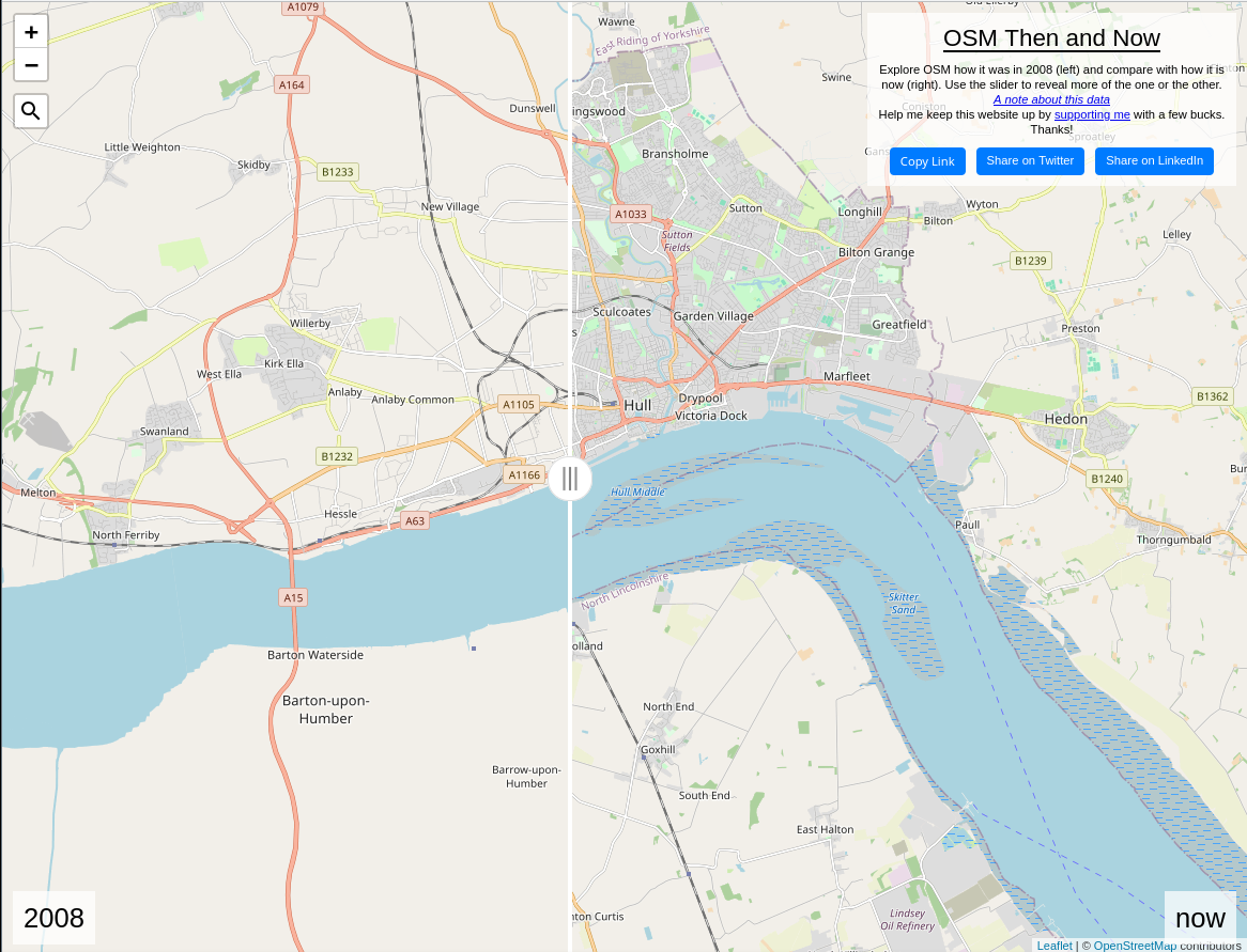
OSM v roce 2008 a 2024 [1] | © Martin van Exel | mapová data © přispěvatelé OpenStreetMap
OSM CZ
- Onovy informuje o záměru uklidit tag
operatori pro ČEZ distribuci. - Ujme se někdo úkolu přidat
ref:ruian:addrke všem adresním místům? - Jak zjistit, kterou moji Poznámku OSM nějaký mapper vyřešil?
- Pozvánka na další kvartální pivo.
OSM SK
- Jak je to s využitím tagu
osmc:symbolpro slovenské cyklotrasy a naučné cyklotrasy? - Informace o chybné sadě změn v rámci výzvy pro opravu budov přes MapRoulette od TomTomu a co s tím.
O nás
- Pieter Vander Vennet vytvořil graf, ve kterém analyzuje odchozí odkazy z WeeklyOSM a srovnává čísla pro Twitter a Mastodon.
Mapování
- Barro sdílí
 ► svůj pohled na vybavení použité pro mikro mapování za jízdy na kole.
 - Zh95967 vytvořil vizualizaci rozložení budov, které zmapoval v malajské oblasti údolí Klang.
 ►
►
Komunita
- Abhishek Nagaraj z university v Berkeley a Henning Piezunka z INSEAD diskutovali o možnosti, že soutěžení může mít nejen pozitivní ale i negativní efekt na motivaci dobrovolníků a domnívají se, že i když soutěžení může zvýšit zapojení pro některé dobrovolníky, jiné to může odradit. Faktorem jsou při tom jak osobní cíle, tak pociťovaná férovost soutěžení. Jejich výzkum sledoval příspěvky do OSM provedené před a po dostupnosti map Google pro různé oblasti.
- 南山少帅Felix198 slaví jeden rok s projektem OpenStreetMap dokončením tisící sady změn.
- Lhirlimann nedávno mapoval ► Mongolsko a stal se nejaktivnějším uživatelem StreetComplete v rámci Mongolska za celý týden.
- Omundy vysvětluje, jak nahrávat stopy GPS ze Stravy do OpenStreetMap.
- Dobrovolníci v San Joséi v americké Kalifornii oslavili narozeniny OSM mapováním komplexů dostupného bydlení ve městě (a také dortem).
- Sangonzag zmapoval ► kolumbijské město Marinilla.
 ►
► ►
►Události
- Jak víte, během tohoto týdne se koná celosvětová konference State of the Map 2024 a to v keňském Nairobi. Náš francouzský dobrovolník SeverinGeo bude v Nairobi a bude informovat o průběhu akce skrze svůj profil na platformě Mastodon. WeeklyOSM se pokusí přetůtat jeho příspěvky a informovat o všech dostupných detailech této akce.
Výzkum OSM
- Během svého výzkumu Benjamin Herfort určil celosvětové průměrné zmapování budov OSM pro městské oblasti na 21%.
Mapy
- [1] Martijn van Exel has vytvořil mapu srovnávající aktuální stav OpenStreetMap s tím, jak to vypadalo v počátkem roku 2008, kdy mapa obsahovala především oblasti, které byly dobře dostupné pro místní přispěvatele a dobře tak ilustruje první kroky snah o komunitní mapování. Všimněte si, že v některých místech mapy jsou data nekompletní kvůli odstranění dat od přispěvatelů, kteří nesouhlasili s migrací licence OSM z Creative Commons na ODbL v roce 2012.
OSM v akci
- Alexey Afanasovich demonstruje ► článek na Wikipedii s šablonou obsahující mapu tématu článku postavenou na datech OSM. Později Alexander ukázal šablonu, která zobrazuje administrativní hranice osídlení.
- iamsummer vytvořil nástroj Noraneko Finder (のらねこふぁいんだー) . Jedná se o interaktivní mapu, která ukazuje místa výskytu toulavých koček na celém světě. Jednotlivé lokality s výskytem toulavých koček jsou sbírány ► s pomocí crowdsourcingu přes formuláře Google a tabulky Google.
 ►
► . Jedná se o interaktivní mapu, která ukazuje místa výskytu toulavých koček na celém světě. Jednotlivé lokality s výskytem toulavých koček jsou
 Otevřená data
- Harry Wood propaguje sesterský projekt Wikipedie jménem WikiVoyage pro vaše dovolenkové aktivity 😉
Software
- Chtěli jste někdy georeferencovat své snímky nahrané do Wikimedia Commons? Podrobný návod krok za krokem pro nástroj locator vysvětluje, jak toho jednoduše dosáhnout.
- Martin Raifer popisuje nedávné aktualizace editoru iD pro OpenStreetMap včetně přidání podpory pro uliční snímky z projektu Panoramax, nové pravidla pro tagovací schémata a také nadcházející novinky jako je režim pro mapování budov, příspěvky komunit či nadcházející události.
Nová vydání
- Verze 2.30 OpenStreetMap editoru iD představuje výrazné přepracování uživatelského rozhraní, přidání schopnosti editovat složité omezení odbočení, vylepšenou správu mapových dat zlepšením výkonu a rozšíření validačního procesu.
Ostatní geo záležitosti
- OpenCage vydal několik #geopodivností o britském Walesu.
- Web Blitzortung nabízí mapy úderů blesků v reálném čase pro celý svět, takže je možné sledovat bouřkové aktivity.
Plánované události
| kde | co | online | kdy | země |
|---|---|---|---|---|
| Brémy | 🗺️🎂 [Bremen] Mobile Mappingparty mit Kuchen | 01.09.–01.10.2024 |  | |
| Rostock | Vortrag: 20 Jahre OpenStreetMap – Ein Blick auf die Community und ihre Arbeit | 02.09.2024 | | |
| MapRoulette Community Meeting | 03.09.2024 | |||
| iD Community Chat | 03.09.2024 | |||
| Christiansburg | OSM NRV Map Night | 04.09.2024 |  | |
| San Jose | South Bay Map Night | ✓ | 04.09.2024 | |
| Missing Maps London: (Online) Mapathon [eng] | 03.09.2024 | |||
| OSM Indoor Meetup | 04.09.2024 | |||
| Brno | Kvartální OSM pivo | 04.09.2024 |  | |
| Stuttgart | Stuttgarter OpenStreetMap-Treffen | 04.09.2024 | | |
| Nairobi | State of the Map 2024 | 06.09.–08.09.2024 |  | |
| Bengaluru | IndiaFOSS 4.0 | 06.09.–07.09.2024 |  | |
| Kodaň | OSMmapperCPH | 08.09.2024 |  | |
| Grenoble | Atelier de rentrée du groupe local OpenStreetMap de Grenoble | 09.09.2024 |  | |
| 中正區 | OpenStreetMap x Wikidata Taipei #68 | 09.09.2024 |  | |
| Salt Lake City | OSM Utah Monthly Map Night | 12.09.2024 | | |
| okrsek Lorain | OpenStreetMap Midwest Meetup | ✓ | 12.09.2024 | |
| Stainach-Pürgg | 14. Österreichischer OSM-Stammtisch (online) | 11.09.2024 |  | |
| Berlín | 195. Berlin-Brandenburg OpenStreetMap Stammtisch | 12.09.2024 | | |
| Mnichov | Münchner OSM-Treffen | 12.09.2024 | | |
| Bochum | Bochumer OSM Treffen | 12.09.2024 | | |
| OSMF Engineering Working Group meeting | 13.09.2024 | |||
| Bielefeld | OSM Ostwestfalen-Lippe | 16.09.2024 | |
Poznámka: Pokud zde chcete vidět vaši akci
Návrhy na zajímavé odkazy pro příští čísla nám můžete poslat zde a podělit se tak o ně s našimi čtenáři.
Toto číslo přeložil tom.k a redakčně upravili mkyral a Jakuje. Budeme velmi rádi, pokud podpoříte a oceníte naši práci tím, že budete dílo dále šířit, např. sdílením na sociálních sítích (like, retweet, boost…). Předem za to děkujeme.
Každé číslo v CZ verzi je promováno zde: @osmcz |
  Talk-cz | osm_sk |
  rss |
rss |  @osmcz
Můžete nás kontaktovat e-mailem:  weekly@openstreetmap.cz
Originál tohoto souhrnu připravili: Raquel Dezidério Souto, SeverinGeo, Strubbl, TheSwavu, YoViajo, barefootstache, derFred, mcliquid, rtnf.