05/06/2018-11/06/2018
OSM-RDC / Potentiel 3.0 are planning OpenCities project in Kinshasa to map areas at risk of floods and cholera 1 | © OSM RD Congo
Mapping
- Bryan Housel, developer of iD, explained on the tagging mailing list why he will not support the
transit:lanestag on ways. It may be possible to support the mapping variant based on relations instead. - A post about the tagging of grass provoked a huge discussion on the tagging mailing list. The title of the post, ‘The endless debate about “landcover” as a top-level tag’ seems quite apt.
- On the Talk-GB mailing list the project MapThePaths was announced. MapThePaths is intended to improve the completeness of legal rights of way and permissive paths in England and Wales in OSM by visualizing missing entries. At the moment it is a pure viewer, but the creator plans to add an edit function.
- The aftermath of an anonymous edit to alter the names of subway stations that also connect to surface lines in Berlin provoked some discussion on the German forum (automatic translation) about how stations should be named. This led to a discussion about tagging in complex junction stations.
Community
- Heikki Vesanto created a presentation for OSGeo Ireland, that shows the evolution of OSM there. He published a guide for creating your own animations with Python, PostgreSQL, osmium-tools and QGIS on his blog.
- On the Talk-US mailing list, a common discussion about an import in George’s County, Maryland became an interesting conversation about the use of Slack or real-time communication tools in general, which also encouraged participants outside the US to join. OSM US already uses Slack, which is not liked by everyone.
Imports
- The mapper johnparis announces a bulk edit on the import mailing list from bus stops in Paris. He would like to supplement certain characteristics (Zone, Stop-ID and Ref) of Île-de-France Mobilités, formerly STIF (Syndicat des Transports d’Île-de-France).
OpenStreetMap Foundation
- The OSMF board accepted a circular resolution to publish the preliminary version of the new OSMF Privacy Policy which has been worked out by the License Working Group.
- The minutes of the State of the Map Working Group meeting of May 27th is online.
Events
- Members of the HOT community can get a 60% discount USD 650 ticket price for HOT Summit 2018 which joins FOSS4G 2018 happening in Dar es Salaam, Tanzania from August 27th to September 2nd.
- The international State of the Map 2018 conference takes place in Milan, Italy from July 28th to the 30th. The community ticket costs EUR 120.
Humanitarian OSM
- Pierre Béland published stats of the OSM-RDC response to the Ebola outbreak with more than 800 remote contributors and 1.4 million objects edited since May 8th. NGOs and local organizations have also added POIs to the map and organized a mapathon for the local actors to revise and complete the map.
- On the HOT mailing list, Remígio Chilaule has presented a short video that shows the mapping activities in Mafala, Mozambique.
- HOT US Inc. advertises a job for a paid part-time PR manager.
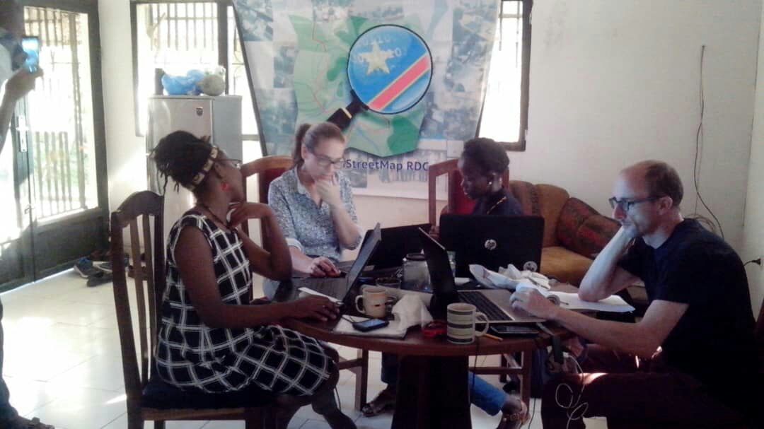
- OpenStreetMap-RDC starts the #OpenCitiesKinshasa new mapping project and requests help from the global OSM Community to map dense neighbourhoods of Kinshasa prone to floods and cholera outbreak. This will support the local OSM contributors which are trained actually for field data collection and Drone missions. These actions are part of a partnership with the World Bank GFDRR, OSFAC and Potentiel3.0 to map vulnerable neighbourhoods of Kinshasa in the context of the “Open Cities Africa” project.
- John Whelan reports on the HOT list about duplicate tasks created in the HOT Tasking Manager and creation of duplicate buildings. For some, mapathon organizers should assure training and validation of their participants and inform the coordinators of the humanitarian response of their actions. This OSM response to the Ebola outbreak is coordinated by OSM-RDC with the DRC Government, the UN Agencies and NGOs in the north of DRC.
switch2OSM
- CPSolver presented his web page www.newsherenow.com on Reddit. It offers news particular to a neighbourhood.
- Google Maps currently disallows access without an API key, as announced. This caused an inrush of requests on the OpenStreetMap Foundation Nominatim server.
Licences
- 70 key figures of the Internet warn about the new EU Copyright Directive in an open letter (PDF), which will be voted by the EU Parliament’s Committee on Legal Affairs on June 20th. The policy forces Internet platforms to automatically check uploaded content for copyright infringements. Julia Reda, MP of the German Pirate Party, wrote in her blog that there is a narrow majority in favour of the directive and asks to call MPs on the phone.
- More than 100 Members of the European Parliament fear that the Europe wide introduction of an ancillary copyright law based on the existing German model could lead to a “link tax” and reject it in a public statement. Spiegel Online, as one of the largest German news website, already has experience with the law. In a comment, it wrote “Rarely was a law so dysfunctional…”
Software
- Simon Poole reports on the Talk mailing list that the upcoming version 11 of the Android editor Vespucci will allow the integration of GeoJSON as a layer. The beta of the version can be installed via Google Play and from GitHub.
- Wikimedia announced its new geocoding extension for CiviCRM, that uses OSM as default geodata provider.
- Cosmogony is a new open source tool designed for easy extraction of boundary data. A dashboard provides a plausibility check of the boundary data in OSM and a hierarchical exploration is possible directly from the map. The data download feature has not been implemented yet. Similar services are mentioned on GitHub.
Programming
- OSM Buildings published their privacy policy and a few updates on how to use their services.
Did you know …
- .. that the mapper Lübeck created a map showing the locations of available defibrillators? Hopefully, you’ll never need this map.
OSM in the media
- Glyn Moody wrote on linuxjournal.com that OpenStreetMap should be “a priority for the open source community”. He addresses Serge Wroclawski’s articles from 2014 and 2018 and concludes that OSM “has the potential to provide ambitious coders with the scope to make their mark in a new field of interest to billions of users.” In his opinion, it is necessary to create more software tools (e.g. Waze) to counter the overpowering market companion. He suggests a collaboration with financially strong open source organisations, such as Mozilla Foundation and Canonical.
Other “geo” things
- MachinePix tweeted a video by Dom Ricciobene, featuring a CNC machine sculpting a mountain landscape on a layered wood block.
- For the friends of Riesling, there is now a historical map available. It belongs to a whole series of historical maps, which is operated by the “Database of Cultural Heritage in the Trier Region”. As the person in charge confirmed on Twitter, the wine map can be used as WMS for OSM.
- Grough magazine reports that Nigel Clifford has not renewed his contract as CEO of the British Ordnance Survey. This increases speculation regarding the lack of an announcement from the Geospatial Commission in May.
- Since the 1930s, some 35 local volunteers have measured the spread and retreat of Icelandic glaciers at 64 measuring points using measuring tapes. The Atlantic reports on the project and why satellite based remote sensing techniques like the NASA satellite Terra cannot completely replace it.
- Heise reported
 on two new JavaScript frameworks: MusicKit and MapKit JS from Apple. With MapKit JS, you can integrate interactive maps with overlays and controls, including routing services, on your own website. An API key is required for use. 250,000 instances with 25,000 service calls per day are free. A sample implementation has been published by Apple on GitHub.
 - Annette M. Kim warns about the potential inaccuracy of automatic feature detection from satellite images: informal settlements at the fringes of large cities may not be classified as urban areas, and would then be overlooked by city management. Only a combination of remote processing and ground checks can make sure that data available to city planners reflect reality.
- Christoph Hormann writes about news on open satellite images in his blog. Topics include the increased image recording volume of the Sentinel satellites, which is achieved by an optical data link, the new report on data access to the Copernicus programme, to which the Sentinel satellites belong, and current developments in the US Landsat programme, which has been running since 1972.
- There’s one spot in the world right now, where the sun is exactly overhead, and it’s this one. Unfortunately, we are not aware of the website that shows the place where the sun is at its nadir.
 on two new JavaScript frameworks:
 Upcoming Events
| Where | What | When | Country |
|---|---|---|---|
| Munich | Münchner Stammtisch | 2018-06-14 |  |
| San José | Civic Hack Night & Map Night | 2018-06-14 |  |
| Lüneburg | Lüneburger Mappertreffen | 2018-06-19 | |
| Cologne Bonn Airport | Bonner Stammtisch | 2018-06-19 | |
| Sheffield | Pub Meetup | 2018-06-19 |  |
| Viersen | OSM Stammtisch Viersen | 2018-06-19 | |
| Karlsruhe | Stammtisch | 2018-06-20 | |
| Leoben | Stammtisch Obersteiermark | 2018-06-21 |  |
| Essen | Mappertreffen | 2018-06-22 | |
| Kyoto | 幕末京都マッピングパーティ#05:会津藩と京都守護職 | 2018-06-23 |  |
| Essen | 4. OSM-Sommercamp und 10. FOSSGIS-Hackingevent im Linuxhotel | 2018-06-22-2018-06-24 | |
| Rome | Incontro mensile | 2018-06-25 |  |
| Bremen | Bremer Mappertreffen | 2018-06-25 | |
| Lübeck | Lübecker Mappertreffen | 2018-06-28 | |
| Dusseldorf | Stammtisch | 2018-06-29 | |
| Stuttgart | Stuttgarter Stammtisch | 2018-07-04 | |
| Bochum | Mappertreffen | 2018-07-05 | |
| Urspring | Stammtisch Ulmer Alb | 2018-07-05 | |
| Milan | State of the Map 2018 (international conference) | 2018-07-28-2018-07-30 | |
| Dar es Salaam | FOSS4G & HOT Summit 2018 | 2018-08-29-2018-08-31 |  |
| Buenos Aires | State of the Map Latam 2018 | 2018-09-24-2018-09-25 |  |
| Detroit | State of the Map US 2018 | 2018-10-05-2018-10-07 | |
| Bengaluru | State of the Map Asia 2018 (effective date to confirm) | 2018-11-17-2018-11-18 |  |
Note: If you like to see your event here, please put it into the calendar. Only data which is there, will appear in weeklyOSM. Please check your event in our public calendar preview and correct it, where appropriate.
This weeklyOSM was produced by Anne Ghisla, Nakaner, PierZen, Polyglot, SK53, Softgrow, Spanholz, Spec80, YoViajo, derFred, sev_osm.
That available defibrillator map website last updated POI in May 2017 so is probably quite out date
The defibrillator map is out of date being from May 2017, but I am not sure that explains why it only shows less than 50 defibrillators in UK while overpass shows over 1600
https://overpass-turbo.eu/s/zCU