19/01/2021-25/01/2021
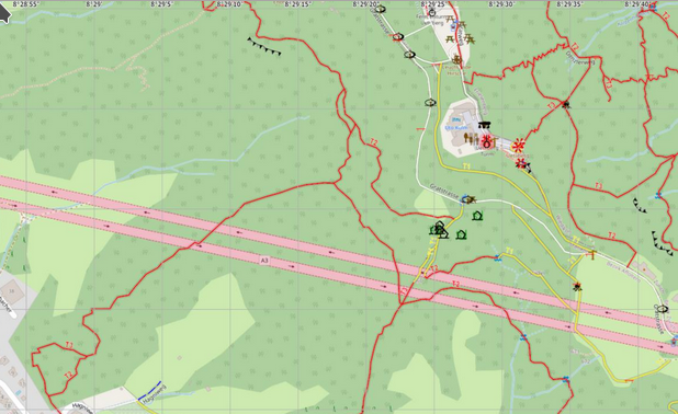
OSM map could do with a layer oriented towards outdoor users? 1 | © Peter Berger | map data © OpenStreetMap contributors
Mapping
- Fernando Trebien has proposed a revision to the
highway=trunkclassification description in Highway Tag Africa. Pierre Béland and others refer to previous discussions and explain the exceptions applicable in Africa for major inter-Africa networks and propose amending the wiki to refer to the Trans-African Highway network and the Southern African Development Community Regional Trunk Road Network (SADC RTRN). - Peter Neale (user PeterPan99) has created his first proposal, focused on the key
addr:parentstreet. This key is already being used for mapping addresses with two street names, and he suggests it would benefit from being included in the standard tags. The RFC started on 20 January. - b-unicycling wrote about improving the tagging of historical features in Ireland.
- OpenMap Development Tanzania reported on activities and results from generating community data for improved disaster management and urban planning in Mwanza, Tanzania.
- How are sidewalks typically mapped? With the
sidewalk=*tag or as a separate way? Both answers would be wrong; see this analysis (the answer is ‘it depends’, see the analysis as to why). - MapBeks is mapping three of the 24 most under-mapped towns in the Philippines.
- Mateusz Konieczny has drawn attention to the current ‘no-show paradox‘ in voting on proposals. His proposal to fix this can now be voted on until Tuesday 2 February.
- The vote on the proposal for
man_made=guard_stonehas begun. - Voting has started on the tag
stone_type=ogham_stone, to map a stone with a Ogham script on it, most commonly found in Ireland as free standing stones, lying on the ground, recycled in buildings such as churches or as artefacts in museums. Voting ends on Monday 8 February. - Voting is open until Tuesday 9 February for
man_made=tailings_pond, a body of liquid or mining slurry used to store the byproducts of mining operations. - Peter Neale asked on the tagging mailing list how to deal with a ‘messy situation’, and was advised to document it on the wiki, which he has now done. The problem concerns inconsistencies of street names in various sources and on the ground.
Community
- [1] Peter Berger feels
 > that the Swiss OSM map could do with a layer oriented towards outdoor users. After discussions with Stefan Keller and Rafael Das Gupta he compiled a draft with some illustrated suggestions for path symbology using Maperitive. Various other suggestions have been made in the thread on talk-ch.
 - Maning Sambale wrote a short summary of OpenStreetMap activities in the Philippines 2020.
- pietervdvn has started a query on Reddit asking ‘what are the weirdest and most original use cases of OpenStreetMap?’
- Supaplex wrote about Dan Jacobson, who found that the Taiwan Power Company had updated its power pole dataset to use the TWD67 coordinate system. But if you inspect the dataset, you will find that it has some special parameters, and it could not be transformed correctly into WGS84.
 >
> 
OpenStreetMap Foundation
- The OSMF has launched a survey among the OSM community. The survey is available in many languages and ends on Sunday 14 February. Some numbers as of Thursday 28 January, 18:00 UTC: Complete responses 1998, Incomplete responses 767, Total responses 2765, Number of tokens sent 3176.
- Christoph Hormann shared, in a very detailed manner, his would-be answers to the OSMF board survey.
Local chapter news
- Minh Nguyen is promoting his candidacy for re-election to the OpenStreetMap US Board of Directors in 2021 and encourages people to vote.
Events
- The State of the Map 2021 is looking for a logo. Check the design contest guidelines and submit, by email, your proposed logo. The deadline is 11:59 PM (UTC) on Sunday 14 February.
Humanitarian OSM
- The DRK (German Red Cross) General Secretariat, together with HeiGIT (Heidelberg Institute for Geoinformation Technology at Heidelberg University), have launched > a handbook in the form of a lexicon of organisations and tools involved in mapathons. The handbook is the result of the ’25 Mapathons’ project. The collaboration between these two entities started in 2017 and focused mainly on humanitarian mapping around the international work of the DRC.
- During 2020 OpenStreetMap Senegal received a ‘Rapid Response Microgrant’ to map hospitals and update information on emergency health services. Daniel Abanto Graffman showed how the data evolved over the project’s timeline and the impact of newly available information on emergency services and capacity assessed with the Openrouteservice.
- Nicolas Chavent is running as a candidate for a vacant post on the HOT US Inc. board of directors. He wrote a post with his vision in his OSM diary.
Maps
- William Ray used a range of data, including from OSM, to produce isochrons showing access to amenities in Oxford, based on blended scores of several inputs (shops, green space, healthcare facilities). At present these inputs are not weighted.
- Johnny Harris shares, in a 30 minute video, his experiences making maps.
- Christopher Beddow writes, in his second of three blog posts, about the background and importance of Maps.me.
Programming
- Maptiler provided a more formal announcement of the MapLibre fork of Mapbox GL, which we mentioned in passing at the time of Mapbox GL becoming proprietary software.
Did you know …
- … that MateKa’te shows all of the facilities serving Club-Mate (
drink:club-mate=*) that are mapped in OSM? - … the evaluation by Pascal Neis of an OpenStreetMap contributor’s profile? Admittedly, not quite new, but the ‘old hands’ like to look at the evaluations of other mappers or for a personal sense of achievement on their own profile. Just enter the OSM user name of the mapper you are interested in.
Other “geo” things
- Kenneth Field picked his favourite maps from 2020.
- Dan Maloney tells the story of Christopher Getschmann, who built a wall-mounted CNC plotter to draw maps directly onto the wall.
- Researchers from the European Space Agency and the EU Satellite Centre have used machine learning techniques to identify roads in desert areas from Copernicus satellite imagery. Existing roads mapped in OSM were used to train the model.
Upcoming Events
| Where | What | Online | When | Country |
|---|---|---|---|---|
| OSMF Survey 2021 | 2021-01-25 – 2021-02-14 | |||
| Kampala | Mapping Uganda’s New Cities | 2021-01-30 – 2021-01-31 |  | |
| Roma | Compleanno Local Chapter italiano OSM | 2021-01-30 |  | |
| Delft | eMWRE Mapathon | ✓ | 2021-02-01 |  |
| 臺北市 | OSM x Wikidata #25 | 2021-02-01 |  | |
| Osm2pgsql Virtual Meetup | 2021-02-02 | |||
| London | Missing Maps London Mapathon | ✓ | 2021-02-02 | gb |
| Landau an der Isar | Virtuelles Niederbayern-Treffen | ✓ | 2021-02-02 |  |
| The European Missing Maps Mapathon | 2021-02-03 | |||
| San Jose | Virtual Civic Hack & Map Night | ✓ | 2021-02-05 |  |
| Dresden | Dresdner OSM-Stammtisch | ✓ | 2021-02-04 | |
| Fortaleza | Mapatona HOTOSM Labocart – UFC | 2021-02-06 |  | |
| Hamburg | Hamburger Mappertreffen | 2021-02-09 | | |
| Missing Maps DRK Online Mapathon | 2021-02-09 | |||
| München | Münchner OSM-Stammtisch | 2021-02-10 | | |
| Zürich | OSM-Treffen Zürich | 2021-02-11 |  | |
| Chippewa Township | OpenStreetMap Michigan Meetup | ✓ | 2021-02-12 | |
| Berlin | 152. Berlin-Brandenburg OpenStreetMap Stammtisch (Online) | 2021-02-12 | | |
| 136. Treffen des OSM-Stammtisches Bonn | 2021-02-16 | |||
| Lüneburg | Lüneburger Mappertreffen (online) | 2021-02-16 | | |
| Albuquerque | MapABQ February virtual meetup | 2021-02-18 | | |
| Stammtisch Köln | 2021-02-17 | |||
| San Jose | Virtual Civic Hack & Map Night | ✓ | 2021-02-19 | |
Note:
If you like to see your event here, please put it into the OSM calendar. Only data which is there, will appear in weeklyOSM.
This weeklyOSM was produced by Nordpfeil, PierZen, Polyglot, rogehm, SK53, Sammyhawkrad, TheSwavu, YoViajo, derFred, edvac.