23/02/2021-01/03/2021
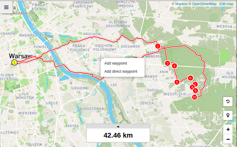
Ed Freyfogle talks with Sam Crawford about his OSM-based route planner for runners 1 | © Sam Crawford | map data © OpenStreetMap contributors
About us
- weeklyOSM contributor Rogehm has published his interview with Lamine Ndiaye, who uploaded changeset 10⁸.
Mapping
- TheSvawu has tweaked “osm-in-realtime” so that it starts at 99,999,800, so that you can look again at the mapping activities near changeset 100,000,000. Interesting to see who was mapping around the magic number. It is also interesting to read the comments on some of the changesets 😉
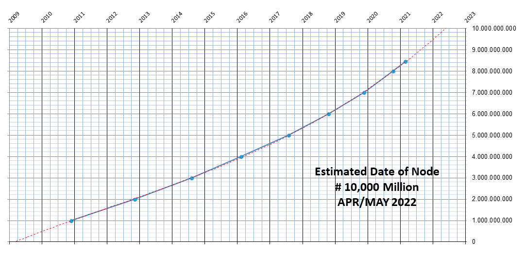
Changeset Mapper Comments ..99,999,991 LucGommans “Greetings from the Netherlands!” ..99,999,999 AE35 “99999999 is definitely a cooler number than 100000000” 100,000,000 Lamine Ndiaye mapper of changeset 10⁸ 100,000,001 MikeN “Congrats on the 100,000,000th changeset!!! (Changeset 0 doesn’t exist anyway)” 100,000,040 overflorian Advertising for a good cause in a congratulatory comment is always possible 100,000,058 Allison P “added house (hello 100 million!!!)” 100,000,176 Steve We were 52 seconds away from what would have been the best coincidence 100.001.328 Stereo Congrats to the 100 Million Village 😉 - We just had the 100 millionth changeset and at the same time the 8,458,919,620th node and the 910,977,970th way. Here you can see when 110 million changesets, 10 billion nodes and 1 billion ways are to be expected.
- As directed by OSM’s Organised Editing Guidelines, the Tallinn-based company Bolt is now writing to communities in a number of OSM countries about where they are planning to map. Reactions have included ‘our roads are already complete’ and ‘contributions in newly-built suburban areas might be helpful’. Bolt were originally brought to the attention of OSM’s Data Working Group, not because of poor mapping, but because a local OSM community (in Sweden) didn’t know who they were, because the initial changesets and user account details did not say – a clear indication of the advantage to the company doing the mapping of following the guidelines.
- Last week we reported on the longest highway on OSM. No sooner had we done so than Christoph Hormann (imagico) added a correction to the thread ‘you are not even close’.
- Kevin Karson (user karsonkevin2) has been extending the mapping of athletics tracks in Iowa, and produced a visualisation showing every track in its correct orientation. Click on a track to see it on OSM.
- Stephanie May has been mapping parklets in Seattle, as they are particularly valuable during these Corona times. They opted for
leisure=outdoor_seatingandoutdoor_seating=parkletas the main tag, but in the San Francisco Bay arealeisure=parklet(not documented) has been used, so they are seeking further views on the matter. (A similar discussion occurred recently on the UK mailing list, which threw another option into the mix:leisure=garden.) - The following proposals are awaiting comments:
historic=tomb, proposed by Martin Koppenhoefer, to provide a tag for all kind of tombs: mausoleums, pyramids, simple tombs, prehistoric tombs, tumuli, rock-cut tombs.nudism=designated, proposed by Tamas Rell, for a beach/resort/etc. which is officially designated as nudist, but nudity is not obligatory. Basically an official public nude beach.
- Voting has ended for the following proposals:
historic=ogham_stonewas successful with 14 votes for, 1 votes against, and 1 abstention.
Community
- Luc Gommans provides a formidably detailed analysis of how mappers tried to game being the person to make the milestone changeset of 100,000,000 (which we featured last week). Clearly, this event brought out the inner geek in many of us.
- Using data from the recent OSMF Community Survey, Jennings Anderson posted an analysis of per-country editing activity since 2020. The distribution of local/non-local mappers per country and the number of edits per user vary greatly among countries. The analysis notebook is available online.
- Have a look at the International Women’s Day 2021 events! The American Red Cross and Missing Maps are hosting the International Women’s Day Mapathon 2021.
- Mike Collinson gave an excellent summary of ‘how we got to where we are’ with
highway=trackandsurface=*, on the Australian mailing list.
OpenStreetMap Foundation
- On 10 and 11 March (Wednesday and Thursday) OSMF Chair Allan Mustard will present a series of three BigBlueButton video conferences open to the OSM community to answer questions about the survey results. The sessions will be at noon UTC and 20:00 UTC on 10 March, and 04:00 UTC on 11 March (these correspond to 07:00, 15:00, and 23:00 EST). He will present some summaries of the data in graphical form, then take questions. He will use his BigBlueButton home room.Allan also plans to open an instance of Microsoft Translator and will share the access code for the instance at the start of the presentation, so that anybody with Microsoft Translator’s app (on desktop, notebook, tablet, or smart phone) can follow the presentation in the language of their choosing. He will also use the PowerPoint 365 speech to text feature to offer English subtitles. Anyone planning to view the video conference should download the Microsoft Translator app in advance and become familiar with it first.
- Christoph Hormann shared
 > his insight about a Meeting of the OSMF Board with the Advisory Board, Local Chapter Members and an ESRI representative, held on 24 February.
 - Michal Migurski prepared two diary entries with maps that illustrate the results of the OSMF Community Survey. The first post focuses on mappers and survey respondents, while the second is dedicated to Board priorities and technology policies.
- Giuseppe Puntofisso, the head of NHSX (AI skunkworks for the NHS) is experiencing difficulty contacting the OSMF Legal working group.
 >
> 
Local chapter news
- Nathalie Sidibe announced, on the Talk-africa mailing list, that OSM Mali is now officially registered as ‘Association OpenStreetMap Mali’.
Events
- The State of the Map Africa (SotM Africa) is regional conference, held every other year, that celebrates the culture of open mapping, open data, GIS, and its impact across Africa. SotM Africa 2021 is scheduled for 19 to 21 November and will take place in Nairobi, Kenya. The conference’s theme will be ‘Leaving no one behind: Emerging from a global pandemic’.
- An online Torino mapping party will be held > this Wednesday 10 March from 15:30 to 18:30 CET. The activity is jointly organised by 5T and ITHACA, and will take place completely online. This year’s theme will be ‘Collaborative mapping for better living’, to teach new digital tools to everyone with the aim of better understanding the territory we live in.
 >
> Maps
- The latest post from HeiGIT looks at the completeness of OpenStreetMap railway network data for a specific city, Prague, and its development over time. Furthermore, the article animates the development of the railway network mapping with instructions so you can learn how to make one yourself.
- Hell freezes over: UK’s Ordnance Survey has launched an OSM-based app in Australia.
Open Data
- Last summer Ivan Gayton explained eloquently how the use of proprietary software reinforces racial and postcolonial inequalities. High costs, and erroneous cost-benefit analyses associated with proprietary tools, mean that it is mainly people from Western countries who acquire expertise. People from affected areas therefore benefit much more from the use of free software. Imma Mwanja recommended the article in the course of the webinar ‘Colonialism in Open Data and Mapping’.
- The Swiss OpenStreetMap association (SOSM) welcomed swisstopo, the national mapping agency, to the open data world. The blog post explains some caveats about the licensing of swisstopo data in the context of OSM.
Licences
- Nuno Miguel Azevedo reported in a tweet that the Angra do Heroísmo City Council, in the Azores, recently launched the app MyAngra, available for Android and iOS. It is a tool for locating the main points of interest in the municipality. What’s missing is the proper licensing and attribution of the base map to OpenStreetMap.
 in a tweet that the Angra do Heroísmo City Council, in the Azores, recently launched the app MyAngra, available for
 Software
- Nominatim, the open-source geocoding tool based on OpenStreetMap data, introduced a command-line version leading to many changes such as much less fiddling with PHP scripts.
- The free software Offroad is an offline map viewer for the desktop. It is based on OsmAnd.
Programming
- In episode 61 of the Geomob Podcast, Ed Freyfogle talks with Sam Crawford, developer of Trail Router, an OSM-based route planner for runners.
- You can read a dialogue-like tutorial between Pierre Béland and Jean-Marc Viglino, the author of the ol-ext OpenLayers Extension tools, about the dynamic addition of layers to an OpenLayers Map using WMS Servers catalogue queries.You can test yourself with the WMS Capabilities example providing your own GetCapabilities request like this for OSM-France https://wms.openstreetmap.fr/wms?service=wms&version=1.3.0&request=GetCapabilities (For security reasons, OpenLayers accepts cross-origin requests only if authorised by the WMS Server with the header [Access-Control-Allow-Origin, *].)
 between Pierre Béland and Jean-Marc Viglino, the author of the
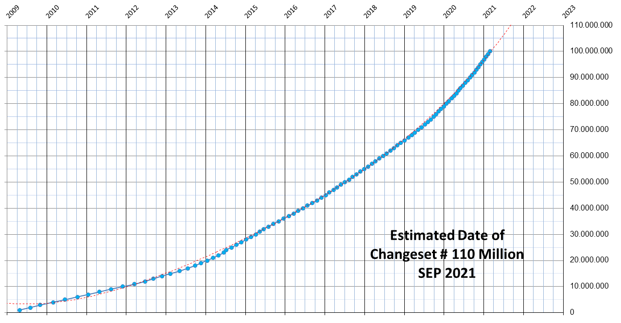
Releases
- Version 3.0 of Nominatim-UI adds theming and other features which make the user interface independent from the standard installation on openstreetmap.org servers.
Did you know …
- … the OSM principle that you can use any meaningful tag you want? Sometimes it’s helpful to coordinate with other community members, but that’s not a requirement. Think of a meaningful tag, make sure it doesn’t clash with or contradict tags already in use, document it on the wiki, move out into the world and map!
- … that the UN Mappers run weekly mapathons? Two hours with them to learn, discuss, and map together, supporting UN peacekeeping missions in Africa. Each week an in-depth look at a different topic! You can register here.
- … the World’s Population map in 3D, created by Matt Daniels?
OSM in the media
- The privacy-oriented Italian website Le Alternative updated its post > about alternatives to Google Maps, which prominently features OSM-related tools.
Other “geo” things
- Bloomberg CityLab reported on how cities designed for motor cars are less efficient for public transport. The article is based on the work of graduate student DW Rowland (University of Maryland) who used OSM data to analyse the street networks of a number of US cities.
- A historic 19th century house was moved, by road, in San Francisco. Needless to say care was taken to move the equivalent element on OSM. An article in The Guardian provides some more information on the history of moving houses in this way.
- Kontur released its Global Fires viewer, allowing you to see a year of fire data on a mobile device and find places nearby with clean air to escape to during the wildfire season. They customised Unfolded Map SDK and pulled in the fire event feed to visualise the wildfire patterns. Users can see the state of air quality for the past three days to find a spot clear from smoke pollution.
- Scottish geospatial firm thinkWhere have won a contract as part of the Open Maps for Europe project, led by EuroGeographics, a not-for-profit umbrella company representing national mapping and cadastral agencies.
- Zimbabwean Tawanda Kanhema gave a TED talk about his work adding new places in Zimbabwe, Namibia, and Northern Ontario to Google Street View.
- On GearJunkie Austin Beck-Doss presented the best Garmin handheld GPS devices of 2021, in the categories Best Overall, Best Budget, Best for Messaging, and Best of the Rest.
- OpenCulture featured Sasha Trubetskoy’s map of Roman roads in Gaul (modern France) in the style of a metro rail network map.
- An international research team has developed an approach, using publicly available big data, to measure environmental inclusivity in cities.
- Jagran Josh, an education portal, provided an overview of India’s new mapping policy, which we reported last week.
- Why do we need to think about ethics when using satellite data for development?
- How-To Geek suggests DuckDuckGo maps as an alternative map provider to Google.
Upcoming Events
| Where | What | Online | When | Country |
|---|---|---|---|---|
| Пенза | Remote mapping party in Penza | Домашняя картовечеринка в Пензе | 2021-02-19 – 2021-03-08 | |
| Open Data Day 2021 | 2021-03-06 | |||
| Kaolack | Open Data Day – OSM – YouthMappers USSEIN | 2021-03-06 | sn | |
| Dar es Salaam | Tanzania Data Lab + OpenMap Development Tanzania: HIV/AIDS hotspots and testing facilities Mapathon | 2021-03-06 |  | |
| Kampala | OpenStreetMap Uganda Mapping Uganda’s New Cities Mapthon | 2021-03-06 |  | |
| 臺北市 | Open Data Day Taiwan 2021 | 2021-03-06 |  | |
| Quezon City | MAPAbabae 2021: #ChooseToChallenge Gender Inequality in Open Mapping | ✓ | 2021-03-06 |  |
| Open Gender Data for Tanzania – What is missing? Why does it matter? | 2021-03-06 | |||
| Missing Maps American Red Cross International Women’s Day Mapathon 2021 | 2021-03-08 | |||
| काठमाडौं | #VisibleWomen : an initiative by Kathmandu Living Labs to put women on the map | 2021-03-08 |  | |
| Missing Maps CartONG Mapathon | 2021-03-08 | |||
| 臺北市 | OSM x Wikidata #26 | 2021-03-08 | | |
| Osborne County | International Women’s Day – Ladies Night Mappy Hour | ✓ | 2021-03-09 |  |
| Hamburg | Hamburger Mappertreffen | 2021-03-09 |  | |
| Briefing on OSMF 2021 Community Survey | 2021-03-10 | |||
| Torino Virtual Mapping Party 2021 | 2021-03-10 | |||
| Missing Maps German Red Cross Einführung JOSM Mapathon | 2021-03-10 | |||
| Chippewa Township | OpenStreetMap Michigan Meetup | ✓ | 2021-03-11 | |
| Briefing on the 2021 OSMF Community Survey | 2021-03-10 | |||
| Briefing on the 2021 OSMF Community Survey | 2021-03-11 | |||
| NIGERIA SE4ALL Remote Mapathon | 2021-03-11 | |||
| UN Mappers weekly mapathon | 2021-03-11 | |||
| Zürich | OSM-Treffen Zürich | 2021-03-11 |  | |
| München | Münchner OSM-Stammtisch | 2021-03-11 | | |
| Berlin | 153. Berlin-Brandenburg OpenStreetMap Stammtisch (Online) | 2021-03-11 | | |
| Berlin | Remote DB Regio Hackathon | 2021-03-12 – 2021-03-13 | | |
| Collaborative and Humanitarian Mapping #2: Mapping deforestation in the Amazon rainforest with JOSM | 2021-03-12 | |||
| Missing Maps Friends of MSF Lancaster Mapathon | 2021-03-13 | |||
| Bamako | She Maps & GIS | 2021-03-13 | ml | |
| Missing Maps CartONG Mapathon | 2021-03-15 | |||
| 137. Treffen des OSM-Stammtisches Bonn | 2021-03-16 | |||
| Berlin | OSM-Verkehrswende #21 (Online) | 2021-03-16 | | |
| Lüneburg | Lüneburger Mappertreffen (online) | 2021-03-16 | | |
| Albuquerque | MapABQ March virtual meetup | 2021-03-18 | | |
| San Jose | Virtual Civic Hack & Map Night | ✓ | 2021-03-19 | |
| UN Mappers weekly mapathon | 2021-03-19 | |||
| Missing Maps CartONG Mapathon | 2021-03-22 | |||
| Bremen | Bremer Mappertreffen (Online) | 2021-03-22 | | |
| Geomob ft. Michael Montani (Unite Maps, UN Mappers) | 2021-03-24 | |||
| Osborne County | OpenStreetMap U.S. Virtual Mappy Hour | ✓ | 2021-03-25 | |
| Osborne County | ✓ | 2021-03-25 | | |
| GISRUK Webinar: Semantic geographic knowledge on a world-scale, interlinking OpenStreetMap and knowledge graphs | 2021-03-25 | |||
| UN Mappers weekly mapathon | 2021-03-25 | |||
| Mapio Cymru: Found in a map of Wales Workshop | 2021-03-26 | |||
| [Online] OpenStreetMap Foundation board of Directors – public meeting | 2021-03-26 | |||
| Webinar GEAM – GFOSS.it: OpenDroneMap, un ecosistema libero per foto aeree | 2021-03-26 | |||
| Collaborative and Humanitarian Mapping #3: Mapping informal settlements with Mapillary and JOSM | 2021-03-26 | |||
| Düsseldorf | Düsseldorfer OSM-Treffen (online) | 2021-03-26 | |
Note:
If you like to see your event here, please put it into the OSM calendar. Only data which is there, will appear in weeklyOSM.
This weeklyOSM was produced by AnisKoutsi, Anne Ghisla, Lejun, MatthiasMatthias, Nordpfeil, NunoMASAzevedo, PierZen, rogehm, SK53, TheSwavu, YoViajo, richter_fn, tordans.
Bonjour,
Je trouve très intéressant voter hebdo et souhaite m’abonner.
Merci!
Das Interview mit Lamine Ndiaye wurde wieder gelöscht?!
Hier kannst Du es nachlesen: https://weeklyosm.eu/de/100th-millionth-changeset