30/03/2021-05/04/2021
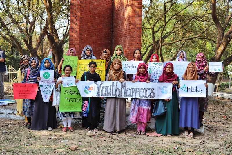
YouthMappers from the University of Chittagong in Bangladesh celebrating International Women’s Day in 2020 [1] | © women’s media center
Mapping campaigns
- ‘The map is power’. For over 50 years, the Waorani of Ecuador have fought the exploitation of their traditional territories. This year, the Waorani won a historic legal victory, in part due to extensive participatory mapping efforts undertaken with partners Amazon Frontlines and Digital Democracy. Alex Yule was lucky enough to witness their victory and the power of community mapping efforts first hand.
- The second UK Quarterly Project of 2021 is ‘Buildings‘. The aim is to trace buildings missing from the map, follow up on construction sites and new builds, or to add more details to already mapped buildings.
Mapping
- The issue of multi-school campuses came up again on the tagging mailing list. This topic has been discussed several times before: for instance, on talk-gb in January 2016 and on the tagging mailing list in April 2019.
- Simon Poole reports that there some updates to his QA tools relating to addresses and road names in Switzerland.
- A young Moroccan developer has single-handedly mapped his home town’s entire public transport network, and created a new app based on Trufi Core.
- Reddit user bompe4 wrote on the OSM subreddit about being confronted by an angry resident whilst surveying. The experience exacerbated existing problems with anxiety. The discussion is well worth reading for practical advice on a real, if relatively rare, problem for mappers.
- Florian Lohoff has extended his address and routing evaluation to Brandenburg and Schleswig-Holstein. He explains
 > that routing can end far from the destination if access roads are incorrectly mapped.
 - The following proposals are open for comments:
was:place_of_worship=mass_rockfor a mass rock which is a rock used as an altar where (Catholic) mass was said during Penal times in Ireland and which was usually used as an altar.landuse=educationfor grounds with multiple educational amenities (e.g. kindergarten, school) in place of using one or moreamenitynodes inside anamenityarea.amenity=clubhousefor a location used and operated by a club.railway:signal:*:shapeallowing mappers to map the visual appearance of railway signals that have the same meaning.- Discourage the use of
railway=preservedand userailway:preserved=yesinstead.
- Voting is underway for:
highway=buswayfor dedicated roadways for bus rapid transit systems (till Wednesday 14 April).
 >
> 
Community
- Brian Sperlongano is proposing to clean up the tagging of rivers and streams in Canada. Several users are supportive of the idea, and some point out the need to check geometries and duplicate polygons as well as the tagging.
- YouthMappers announced a new partnership with the US American Geographical Society. Through this partnership, Courtney Clark will become the Everywhere She Maps Program Director.
- Thomas (SunCobalt) is thinking about how to analyse the roughness of tone in changeset comments compared to that on the OSM talk mail lists. As always, Pascal Neis has a tool for extracting the respective texts.
- Jennings Anderson published a must-read article about paid mapping in OSM. He breaks down the paid editing in his analysis into the countries affected and the corporations making these edits, illustrates the history of paid mapping, and sets out the proportions of paid edits into relation to overall edits in the individual countries. The analysis contains many nice visualisations of the development of this trend. This report is an update of Jennings’s 2019 paper which we reported last year.
Imports
- The OSM community in Sweden is planning a manual import, or rather a coordinated mapping effort, to improve the quality of OSM in Sweden. This effort has already been announced on the import mailing list and more input from interested users is welcome. Further details are laid out on the OSM wiki.
Local chapter news
- In Episode 67 of the Geomob Podcast Ed Freyfogle interviews long-time OSM India contributor Sajjad Anwar about the recent changes in Indian mapping regulations and what this might mean for OpenStreetMap in India.
- OpenStreetMap Belgium’s Mapper of the Month for April is Alouette955, an enthusiastic cyclist and contributor from Montreal.
- OSM UK has submitted a midterm report for their project focusing on leaflets to promote OSM for which the project has received a microgrant.
OSM research
- GIScienceHD has presented the first version of the ohsome-py Python package. ohsome-py helps you extract and analyse OpenStreetMap history data using the ohsome API and Python. It handles queries to the ohsome API and converts its responses to Pandas or GeoPandas data frames to facilitate easy data handling and analysis. The project is still in an early stage, so there might be changes to the package in the future. To learn how ohsome-py works get started with the tutorial.
- Yair Grinberger, Moritz Schott, Martin Raifer and Alexander Zipf have published a report on the impact of of organised mapping events that can produce massive addition of data to OSM in a short period. The study points to the different perspectives of organisations and their unequal geographic distribution; region-specific types of additions; and the intense activities that follow (see this map of the results). This requires consideration when using OpenStreetMap data and analysing their quality.
Humanitarian OSM
- MapUganda has been mapping Ugandan border towns to help local health responders monitor potential avenues for COVID-19 transmission.
- This month, the HOT Philippines team completed the required fieldwork for the PhilAWARE project and is now presenting output maps to stakeholders.
- Public Lab Mongolia has used support from a HOT Rapid Response Microgrant to assemble a diverse team of mappers from across Mongolia to map health, service, and infrastructure sites relevant to COVID-19 responses.
Maps
- HeiGIT has visualised, on different maps:
- travel times to health facilities and population coverage at different scales for a variety of countries, and
- travel times to immunisation centres within one’s own state in Germany.
Open Data
- Drone pilot Michael Jones has filed a lawsuit against the North Carolina Board of Surveyors after it threatened him with gaol time and fines for taking aerial photos.
Software
- Mateusz Konieczny published an online tool that generates SVG maps from OSM data. This tool is the first prototype for the microgrant project ‘Tactile maps for blind or visually impaired children’. Feedback is welcome!
- Michel, from the Locus team, presented ‘Locus Map 4’ as a brand new app that offers all the basic map functions for free.
- Yuri Astrakhan called on Mapbox to transfer control of some of their FOSS projects to community governance. The discussion continues in the comments of tilelive’s pull request #222 on GitHub.
Programming
- Following Stephan Knauss’s report of memory leak problems in his rendering chain after updating to the latest version of PostGIS (we reported earlier). Darafei, from PostGIS, redirected him to the trac.osgeo.org/postgis instance to report issues.
Did you know …
- … of the large variety of social media, messengers, and web services contact methods that can be tagged with
contact:*? - … about this handy cheat sheet of JOSM shortcuts?
- … there is an OSM contributor statistics page on the wiki?
OSM in the media
- Directions Magazine described how women’s geospatial perspectives bring new ways of thinking to mapping. Women’s Media Center captured Maliha Mohiuddin’s commitment to the YouthMappers Everywhere She Maps programme, while this interview with the Everywhere She Maps Regional Ambassadors shared Maliha’s and the other ambassadors’ takes on building an inclusive mapping community. YouthMappers is a global network of university student-led chapters at 260 universities across 57 countries.
Other “geo” things
- ‘Desert Networks‘ is a scientific research project funded by the European Research Council and hosted by the HiSoMA research center at Lyon (CNRS – French National Centre for Scientific Research). The project aims to study the physical, economic and social networks that linked together the Egyptian Eastern Desert, from the mid-second millennium BCE until the late third-early fourth century CE. Among the many research results, the website hosts an interactive map which makes it possible to search for sites by location, chronology and characteristics, with additional shapefiles available.
- OpenMap Development Tanzania and the UK Space Agency International Partnership Programme recently concluded the METEOR Project, generating disaster exposure data and models in two pilot countries – Tanzania and Nepal.
- MapBox announced improvements to imagery at many zoom levels, together with more recent data in many areas.
- After what3words, Maps Mania reports that what2figures reduces the need to remember three words, to pinpoint a geolocation, to just two numbers. Not sure where we’ve heard this idea before.
- #geoObserver reported > on a Google-based shelter and bivouac map. The map makers are seeking more shelters and hiking huts, along with photos and additional information, to add to their map. An overpass query of OSM data shows how many are currently missing.
- Geomob interviewed Tim Newman of the Ordnance Survey, the national mapping agency for Great Britain, in episode 66 in their regular series of podcasts. Topics touched on included geodesy, outdoor apps for consumers, and OS’s new app for Australia which includes OSM data (as we reported earlier).
- Cartapaname offers > a puzzle based on the 80 quartiers of Paris and explains their origin.
- Retromap shows you a number of historical map layers, including maps made by the Soviet Union in the 1980s.
- Try to ‘Steer through the Suez Canal’. It’s a very short game.
- The Hindu BusinessLine reported (paywall/sign in needed) that private weather forecaster Skymet is opening up detailed (farm-level) geospatial data via a portal, SkAlgeo, with a view to finding innovative use cases for the data.
 >
> 
Upcoming Events
| Where | What | Online | When | Country |
|---|---|---|---|---|
| Charlottesville | Cville Sidewalks Mapathon | 2021-04-11 |  | |
| 臺北市 | OpenStreetMap x Wikidata 月聚會 #27 | 2021-04-12 |  | |
| 20095 | Hamburger Mappertreffen | 2021-04-13 |  | |
| Using maps to help prevent and respond to Gender Based Violence | 2021-04-14 | |||
| Zürich | 3. Mapathon Rapperswil mit Missing Maps Zürich (virtuell) | ✓ | 2021-04-14 |  |
| Chippewa Township | OpenStreetMap Michigan Meetup | ✓ | 2021-04-15 | |
| Osborne County | OpenStreetMap U.S. Virtual Mappy Hour | ✓ | 2021-04-15 | |
| Liverpool | University of Liverpool Mapathon 2021! | 2021-04-15 | gb | |
| San Jose | Virtual Civic Hack & Map Night | ✓ | 2021-04-16 | |
| PoliMappers: Humanitarian Mapping with Map For Future | 2021-04-16 | |||
| 138. Treffen des OSM-Stammtisches Bonn | 2021-04-20 | |||
| Berlin | OSM-Verkehrswende #22 (Online) | 2021-04-20 | | |
| City of Nottingham | OSM East Midlands/Nottingham meetup (online) | ✓ | 2021-04-20 | gb |
| Lüneburg | Lüneburger Mappertreffen (online) | 2021-04-20 | | |
| Albuquerque | MapABQ April virtual meetup | 2021-04-22 | | |
| Chicago | Loyola University Chicago Friends of MSF Earth Day Mapathon | 2021-04-23 | | |
| Weggis | Swiss OpenStreetMap Association Annual General Meeting | 2021-04-23 | | |
| Bremen | Bremer Mappertreffen (Online) | 2021-04-26 | | |
| Düsseldorf | Düsseldorfer OSM-Treffen (online) | 2021-04-28 | | |
| Salt Lake City | Map The U Spring 2021 | 2021-04-30 – 2021-05-01 | | |
| [Online] OpenStreetMap Foundation board of Directors – public meeting | 2021-04-30 |
Note:
If you like to see your event here, please put it into the OSM calendar. Only data which is there, will appear in weeklyOSM.
This weeklyOSM was produced by Anne Ghisla, Climate_Ben, Nordpfeil, PierZen, Polyglot, SK53, SunCobalt, TheSwavu, YoViajo, dcarneyn, derFred.
Zu “Kennst du schon … den Spickzettel der JOSM-Kurzbefehle?”
Bei Dateien auf Wikimedia-Commons ist es immer besser, statt direkt auf die Datei auf die Dateibeschriebungsseite zu verlinken:
https://commons.wikimedia.org/wiki/File:JOSM_Keyboard_Shortcuts.png
Dort erfährt man auch was über den Autor und die Lizenz.
Im konkreten Fall sollte nicht auf Commons verlinkt werden, sondern auf die Primärquelle
https://openclipart.org/detail/93745/inkscape-keyboard-layoutv048-colored-path-by-baditaflorin
No funcionan los links para entrar a las propuestas.
Vertippt beim Locus map Teil
Im Artikel steht Lotus Map