05/12/2023-11/12/2023
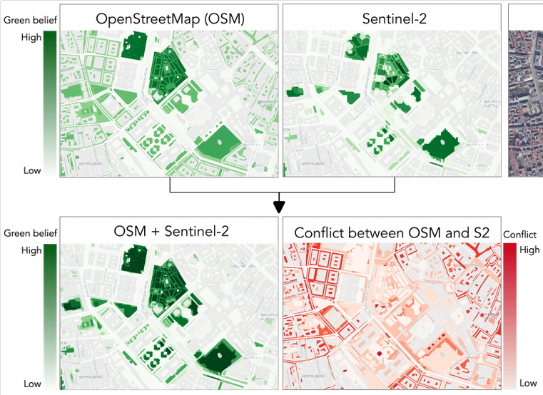
Method for mapping urban green spaces using OSM and Sentinel-2 imagery [1] | © Christina Ludwig
Breaking news
- The 2023 Annual General Meeting of the OpenStreetMap Foundation took place on 16 December at 16:00 UTC. The election of the Board of Directors has been completed and Roland Olbricht, Guillaume Rischard, and Daniela (Dani) Waltersdorfer Jimenez are elected. A total of 913 members voted. The first board meeting to elect officers is scheduled for Thursday 21 December at 13:30 UTC. The OpenStreetMap Foundation also expressed its gratitude towards Mikel, who has been released from his board duties.
About us
- Take part in the competition for the 700th issue of weeklyOSM! Design a header image for the anniversary issue and win an osmflag from FOSSGIS. The closing date for entries is 21 December; more info
Mapping
- António Madeira announced on the Telegram channel of the OSM Portugal group the opening of the vote for the proposal for the standardisation of national built heritage
 drawn up by himself and user Jorge Pinho a few years ago, but which, due to lack of time, was never discussed or put to a vote.
The discussion will be open for three weeks from 00:00 on 15 December, followed by the vote. In addition to the mailing list, the proposal’s discussion page, the Telegram channel and the OSM Community forum are available for discussion. - Requests for comments have been reopened on these proposals:
tourism=camp_lodgingfor tagging small, rentable buildings or shelters with limited amenities, designed for short-term lodging in natural settings.emergency=disaster_responsefor worldwide consistent tagging of disaster response service stations providing emergency response for civilians during or after a disaster.
- Voting is open on:
amenity=bicycle_washto map bicycle wash stations, until Monday 18 December.
- The vote on
crossing:continuous=yes/nohas closed. The proposal was approved with 32 votes in favour, one vote against, and one abstention.
 drawn up by himself and user Jorge Pinho a few years ago, but which, due to lack of time, was never discussed or put to a vote.
Mapping campaigns
- As of 1 January 2024, DB Netz AG and DB Station & Service AG will merge into DB InfraGO AG, requiring a comprehensive update of OpenStreetMap tags in Germany, Switzerland, Belgium, and the Czech Republic. Nakaner announced a manual edit of the affected
operatortags. - MapRoulette has updated its basic OSM checks. There are many new challenges worldwide related to footway conflicting nodes, such as this one.
- Two MapRoulette challenges have been created based on a discussion on the OSM Community forum about link rot in OSM data. These challenges aim to correct URLs in OSM tags that are no longer accessible.
 into DB InfraGO AG, requiring a comprehensive update of OpenStreetMap tags in Germany, Switzerland, Belgium, and the Czech Republic.
 Community
- A regional YouthMappers ambassador wrote about achieving a historic milestone by successfully completing their very first national YouthMappers Summit in Bangladesh, setting a benchmark for their global network.
- Approximately simultaneously, Jochen Topf and mcliquid each obtained permission to use the dataset of electric vehicle charging stations in Germany and Austria. The community is now discussing the possibility of an import.
- On the OpenStreetMap Community forum, a new key,
foot_scale=*, has been proposed to enhance path tagging for walking similarly tosac_scalefor hiking. This scale ranges fromcasual_walking, requiring no special effort, tonot_walkable, indicating paths unsuitable for walking. The intention is to simplify the representation of path attributes, consolidating various existing keys likesurfaceandobstacleinto a more straightforward scale. - Marcus Jaschen wrote ► about the significant growth of Geofabrik’s Europe extract of the OSM database, now around 28 GB, highlighting a steady increase. He has also updated his Gravel Overlay for bikerouter.de, detailing a comprehensive Ansible Playbook process for tile server updates.
- Sakshi Verma, from India, is the UN Mapper of the Month for December.

OpenStreetMap Foundation
- FOSSGIS e.V. ► , the German local chapter of OpenStreetMap, has committed to financially support the OpenStreetMap Foundation annually. This decision, made due to the size and financial resources of the German OSM community and their strong commitment to the project, is unprecedented for an OSM local chapter. For 2023 and 2024 the FOSSGIS board has decided to provide 10,000 EUR.
- The Chairman of the OpenStreetMap Foundation, Guillaume Rischard, reflected in the 2023 chairperson’s report on significant developments and challenges in the OSM community. Key topics included the growth of OSM data, improved community discourse, strategic planning, and technical innovations. The need to strengthen the OSMF structure to enhance its efficiency and effectiveness is particularly emphasised. Join in the discussion here.
Local chapter news
- Włodzimierz Bartczak ► announced ► that the Polish local chapter has unanimously decided to propose that the next State of the Map Europe be hosted in Poland. The conference planned for 2024 will be of particular importance as it will mark the 20th anniversary of the OpenStreetMap project.
- The State of the Map US 2024, the largest gathering of the OpenStreetMap community in the US, will take place 6 to 8 June 2024, in Salt Lake City, Utah. The Call for Speakers has now started and will close on 29 February 2024; contributions from the OSM community are welcome. Presentations ranging from OpenStreetMap fundamentals, to indigenous mapping, to OSM in leisure activities are desired.
 ►
►Events
- The Chaos Communication Congress 2023 (37C3) will take place from 27 to 30 December in Hamburg, Germany, and there will be an OpenStreetMap booth. Will you be there? If so, register on the wiki and let us know in the OSM Community forum.
- The FOSS4G Europe 2024 conference is inviting OpenStreetMap enthusiasts to submit their proposals for general, workshop, and academic sessions. The conference to be held in Tartu, Estonia, will focus on European issues and activities related to free and open source geospatial software and data. Presentations will be streamed online, but presenters are expected to attend in person. The deadline for submissions is 11 February 2024.
OSM research
- [1] Dr. Christina Ludwig successfully defended her doctoral thesis on mapping urban green spaces using OpenStreetMap data and Sentinel-2 satellite imagery. In her work, she analysed how green spaces are mapped in OSM and developed a mapping method that takes into account regional differences, incorporating both the fuzziness in OSM data and the limitations of satellite sensor resolution. This work significantly contributes to improving route suggestions for pedestrians and cyclists by recommending more pleasant paths through green areas.
- A research project on predicting the transportation infrastructure in Indian cities has been published in Scientific Reports. The project uses OpenStreetMap and an innovative RidgeGAN method to analyse complex urban patterns and road network densities using machine learning and satellite imagery. This is an important study for urban planners and researchers working on sustainable urban development and improved transportation networks.
- An innovative research project, published in PLOS ONE, uses satellite monitoring to identify the accumulation of terrestrial plastic waste. By employing neural networks to analyse data from the Sentinel-2 satellite, the system detects plastic waste in twelve Southeast Asian countries. This method identified more than twice as many waste sites in Indonesia, compared to OpenStreetMap and public databases, representing a significant step in monitoring and combating plastic pollution. National Geographic Indonesia reported ► on this.
- A German-Austrian research team has analysed the mass of buildings and infrastructure in the USA in a study published in Nature Communications, revealing remarkable patterns in human-dominated landscapes. The study aims to provide a database for more sustainable use of resources.
 ►
►Humanitarian OSM
- HOT and OpenStreetMap Libya have concluded the 2023 Libya Floods activation. Debrief and after action review notes are available on Pete Masters’s OSM diary. Huge thanks to everyone who contributed!
Maps
- Discover the curiosities of the OpenStreetMap waterworld: a collection of unusual, circular waterways. These are almost always errors in mapping, as rivers and streams forming an endless loop are nearly impossible in reality. This page showcases such rare and fascinating mapping errors. Have fun correcting them.
- Darren Wiens presented a sea level rise simulator, where he uses the AWS Terrain Tiles and the new raster functionality available in Mapbox GL JS v3.
- Stefan Bohacek has created a webmap that lists the world’s governments that manage their own federated servers.
- OpenHiking offers optimised vector maps for hikers based on OpenStreetMap data. These maps highlight hiking routes and symbols, water sources, points of interest, and natural features. They include contour lines and shading and are compatible with Garmin devices as well as Android through apps including OruxMaps and LocusMaps. The maps cover areas such as the Carpathians and the Alps and offer features such as routing and searching for geographical names (Garmin only) and regular updates.
OSM in action
- The Cartotelco website displays all the locations of street cabinets for telecommunication in France on an OpenStreetMap map, colour-coded by their respective operators. By clicking on a marker, the OpenStreetMap node can also be opened directly.
- The ELWIS map view shows the German Nachrichten für die Binnenschifffahrt (News for inland shipping) on an interactive map. Among other data sources , OpenStreetMap is also listed.
- Andrei Kashcha tweeted about the ‘Geo-Mug’, a unique Christmas gift idea for GeoNerds and GIS folks. The mug can be designed with a custom map of any city in the world by using OSM data from a self-chosen bounding box and preferred colours. The geoObserver reported ► on the service.
 all the locations of street cabinets for telecommunication in France on an OpenStreetMap map, colour-coded by their respective operators. By clicking on a marker, the OpenStreetMap node can also be opened directly.
Software
- JOSM will end support for OAuth 1.0a in early 2024 and will remove or hide password logins. It is recommended that all new users use OAuth 2.0, and existing users are encouraged to switch to it.
- JOSM releases (Java archive, Windows, and MacOS) will no longer be signed. The code signing rules have changed and are no longer acceptable to the JOSM team. When using systems relying on code signing warning requests will appear in the future.
- SEMA’s planning and construction programme now allows ► the presentation of 3D models as impressive renderings in Lumion, featuring vibrant environmental design using OpenStreetMap.
- Deepness is a QGIS plugin that allows the execution of segmentation, detection, and regression on raster orthophotos using custom ONNX neural network models. It supports various model types and provides features such as limiting the processing area, integration with layers, and exporting training data. This tool is useful for users who want to apply deep learning to remote sensing.
- Desert Atlas is a new self-hosted OpenStreetMap app for Sandstorm. It allows users to privately search, save, and bookmark places in collaboration with friends for on-the-go use. Desert Atlas integrates with OSM apps like Organic Maps and OsmAnd, enabling users to export their bookmarks. Desert Atlas focuses on privacy and user-friendliness, offering a simple way to download regions and plan in a trusted environment. The app has already been discussed on HackerNews.
- ForestScanner is an iOS app that can create 3D point clouds with LiDAR-enabled iPhones and iPads. Users can capture individual tree information such as diameter and coordinates, save this data, and export it as a CSV file. The app is aimed at users interested in forestry and environmental monitoring, supporting various data collection and processing functions.
- Episode 211 of Geomob featured an interview with Simon Poole, the creator of Vespucci Editor, the first and only full-featured OpenStreetMap editor for Android devices. He talked about his background, the history and development of Vespucci, the challenges and benefits of editing OSM on mobile, and the future plans for the app. The episode is about 40 minutes long and can be listened to on the Geomob website or various podcast platforms.
- The ExifLooter tool extracts geolocation from images using URLs or directories and is integrated with OpenStreetMap. The source, written in Go, is available from GitHub. The tool can be used to analyse images, remove metadata, or combine with other tools. It is suggested for use in security research, OSINT activities, and bug bounty hunting.
- TrailStash has introduced a new browser bookmark on Mastodon that allows you to easily switch between different maps in your browser while maintaining your viewport.
- Jeff Oppong explained, on Geography Realm, how to create isochrone maps with QGIS and how to find shortest and fastest routes using ORS tools and Quickmap services. Ideal for all mapping enthusiasts who want to gain insights into accessibility patterns.
Programming
- Jan Kammerath showcased, on Medium, the power of OpenStreetMap (OSM) by demonstrating how to extract a list of sushi restaurants in Manhattan using Go. He explained that while many mapping services offer similar data, they often come with a cost, especially for extensive queries.
- Discover the ‘viridis’ colour scales on CRAN, specifically designed to enhance the readability of graphics and support colour-blind users. These colour scales are not only colourful and aesthetically pleasing but also designed to remain discernible when converted to greyscale. For R users, they offer a wide range of possibilities, from basic plots to ggplot2 applications.
- In his OpenStreetMap diary entry, Sam Woodcock explained how he uses the PostGIS database to create FlatGeobuf files without having to rely on the extensive GDAL library. He described the process, which involves the use of SQL and SQLAlchemy in FastAPI, and highlights the benefits of this method for generating FlatGeobufs, particularly in terms of efficiency and ease. This approach offers an alternative solution for data preparation and management in geospatial applications.
Releases
- Wahoo has released a new map update for the ELEMNT GPS bike computer based on OpenStreetMap, as detailed in the release notes for Android and iOS. Following the last update in May 2023, this is now the second update for this year. With the wahooMapsCreator tool, you can generate new map material at any time.
- New versions of GeoDesk have been released: 0.1.9 (for Java) and 0.1.1 (for Python). The Java update includes the GOL Tool and addresses bugs like the OsmPbfReader shutdown issue with corrupt source files and a gol build encoding problem affecting way-node access. The Python version introduces improvements such as simplified creation of ‘Coordinate’ objects and better handling of feature sets, alongside fixing bugs such as the incorrect return of Features.members_of() and iteration issues in Tags.
Did you know …
- … osm.el is the OpenStreetMap viewer for Emacs? Osm.el is a tile-based map viewer, with a responsive movable and zoom-able display.
- … LearnOverpass is a beginner-friendly learning resource for the Overpass API? The website offers interactive courses to train users on how to effectively query and utilise OSM data.
- … Leigh Dodds’s Overpass QL tutorial offers a comprehensive guide to the Overpass query language used in OpenStreetMap? This tutorial is designed to teach users the fundamentals of the OpenStreetMap data model, various methods to extract nodes, ways, and relations, and how to perform spatial queries.
OSM in the media
- The Wunstorfer Auepost (a German local newspaper) used ► an excerpt from an OpenStreetMap map, including excellent attribution, in a detailed article about a firefighting operation.
Other “geo” things
- Geo Week News presented a summary of the #30DayMapChallenge on LinkedIn. #30DayMapChallenge features new, theme-based maps every day, from point-based maps of the US to stunning 3D representations of the universe. This article provides a glimpse into the creative highlights of this challenge and showcases some of the most intriguing and visually stunning maps.
- A paper in Scientific Data presented a global land cover dataset that utilises the capabilities of modern cloud computing platforms, such as Google Earth Engine, to map land cover worldwide. The authors have combined machine learning with high-resolution satellite imagery to create a comprehensive picture of global land cover. This research makes a significant contribution to improving the accuracy and availability of land cover data.
- The Daily Map page of the EU ERCC Portal provides a daily overview of significant events or situations related to humanitarian and civil protection interventions by the Directorate-General for European Civil Protection and Humanitarian Aid Operations, or those expected to have humanitarian consequences. These maps are an important tool for coordinating and responding to emergencies and disasters.
- James Killick has put together a humorous, Christmas-inspired wishlist for improvements in the world of map software. The article offers an amusing, festive perspective on mapping applications, and their sometimes curious quirks.
- Milos Popovic tweeted how he combined forest type with elevation data to create a colourful and very impressive map of Europe. On YouTube he explained, over 45 minutes, how he created this map using rayshader in R and data from the Copernicus Global Land Cover project. The entire code is available on GitHub.
Upcoming Events
| Where | What | Online | When | Country |
|---|---|---|---|---|
| Lorain County | OpenStreetMap Midwest Meetup | ✓ | 2023-12-15 |  |
| አዲስ አበባ / Addis Ababa | State of the Map Ethiopia 2023 | 2023-12-15 – 2023-12-16 | et | |
| Amsterdam | Maptime Amsterdam – A very Mappy Christmas! | 2023-12-15 |  | |
| Berlin | 186. Berlin-Brandenburg OpenStreetMap Stammtisch | 2023-12-15 |  | |
| OpenStreetMap Foundation’s board election – Deadline for voting | 2023-12-16 | |||
| [Online] 17th Annual General Meeting of the OpenStreetMap Foundation (second part) | 2023-12-16 | |||
| Београд | Geospatial Community of Serbia – First Meetup | 2023-12-18 |  | |
| City of Westminster | London xmas pub meet-up | 2023-12-18 |  | |
| Berlin | DRK Beginner Online Mapathon | 2023-12-18 | | |
| Lyon | Réunion du groupe local de Lyon | 2023-12-19 |  | |
| Saint-Étienne | Rencontre Saint-Étienne et sud Loire | 2023-12-19 | | |
| Bonn | 170. OSM-Stammtisch Bonn | 2023-12-19 | | |
| IJmuiden | OSM Nederland bijeenkomst (online) | 2023-12-19 | | |
| Lüneburg | Lüneburger Mappertreffen (online) | 2023-12-19 | | |
| UN Mappers Mapatón: MapRoulette Challenge en Somalia | 2023-12-20 | |||
| Karlsruhe | Stammtisch Karlsruhe | 2023-12-20 | | |
| Bengaluru | OSM Bengaluru Mapping Party | 2023-12-23 |  | |
| San Jose | South Bay Map Night | ✓ | 2023-12-27 | |
| Düsseldorf | Düsseldorfer OpenStreetMap-Treffen (online) | 2023-12-29 | |
Note:
If you like to see your event here, please put it into the OSM calendar. Only data which is there, will appear in weeklyOSM.
This weeklyOSM was produced by MatthiasMatthias, PierZen, SeverinGeo, Strubbl, TheSwavu, barefootstache, conradoos, derFred, mcliquid, rtnf.
We welcome link suggestions for the next issue via this form and look forward to your contributions.