12/09/2024-18/09/2024
Ultime notizie
- La prossima riunione del consiglio di amministrazione dell’OSMF si terrà giovedì 26 settembre 2024 alle ore 13:30 UTC, a meno che non venga riprogrammata.
- Il sito web e le API di mappatura di OpenStreetMap.org saranno di sola lettura/parzialmente non disponibili giovedì 26 settembre 2024, dalle 20:00 alle 21:00 (GMT/UTC) a causa di una manutenzione essenziale del server.
Mappatura
- Darkonus ha ricercato
 alcuni approcci ottimali per compilare il tag
 name:enper gli oggetti OSM in Ucraina. - Per migliorare il percorso delle auto in OpenStreetMap, Karussell ha compilato un elenco di circa 3 200 link che probabilmente evidenziano problemi di etichettatura, come strade che si sovrappongono o restrizioni di svolta mancanti.
- Si richiedono commenti su:
- La proposta per aggiungere l’etichettatura per i supplementi e gli sconti, consentendo una mappatura dettagliata degli adeguamenti di prezzo su beni e servizi.
- La proposta per introdurre
highway=unknownper le strade il cui tipo non è chiaro, consentendo l’etichettatura temporanea per ulteriori chiarimenti.
- La proposta per sostituire il tag
denomination=mormoncondenomination=latter_day_saintè aperta al voto fino a venerdì 27 settembre.
 alcuni approcci ottimali per compilare il tag
 Comunità
- b-unicycling ha avviato un progetto di storia orale per raccogliere i ricordi e le storie delle persone sui pozzi sacri della contea di Kilkenny, in Irlanda.
- Barefootstache ha condotto un’indagine di mappatura sul campo utilizzando FitoTrack e OsmAnd in Baviera, Germania.
- Contrapunctus ha pubblicato materiale in lingua hindi e inglese per aumentare la consapevolezza di OpenStreetMap in India. Hanno dato il via a questo progetto nella speranza di distribuire guide stampate alle persone che li bombardano di domande durante le indagini di mappatura sul campo di OSM.
OpenStreetMap Foundation
- La 18ª Assemblea generale annuale (AGM) della OpenStreetMap Foundation si terrà online sabato 19 ottobre 2024, alle ore 16:00 UTC.
Notizie sui Local Chapters
- OpenStreetMap US annuncia che il National Park Service (NPS) è il suo nuovo membro strategico, con l’obiettivo di migliorare i dati geospaziali aperti per proteggere le risorse e migliorare le esperienze dei visitatori nei parchi nazionali degli Stati Uniti.
Eventi
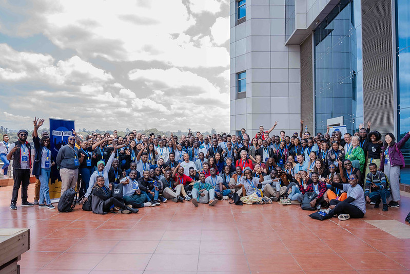
- [1] Le immagini dello State of the Map 2024 a Nairobi sono ora disponibili su Flickr.
- Il prossimo anno lo State of the Map 2025 si terrà a Manila, nelle Filippine.
- I poster di State of the Map 2024 sono disponibili e mostrano la diversità delle applicazioni dei dati dei collaboratori di OpenStreetMap e dei programmi correlati.
- Le persone hanno condiviso le loro esperienze di partecipazione allo State of the Map 2024:
- Ann Caroll ha tenuto la sua presentazione il primo giorno del SotM 2024, intitolata “Women in Tech: Cosa ha funzionato meglio per me” e ha partecipato all’evento sociale al Baobox.
- Erick Tamba ha partecipato allo YouthMappers Pre-Event e al Mapathon presso l’hub dell’Humanitarian OpenStreetMap Team Eastern and Southern Africa prima dell’inizio della SotM 2024 (guarda anche il suo vlog qui).
- Hills95 ha ricevuto una borsa di studio da HOTOSM per partecipare alla sua prima SotM.
- Ibtehal ha condiviso una foto di gruppo con gli altri partecipanti alla SotM.
- Johanes Peter ha tenuto un workshop su “Esportazione di mappe atlante di alta qualità in massa sfruttando i dati di OpenStreetMap in QGIS” e ha esplorato Nairobi durante la convalida dei dati OSM.
- Letwin Pondo ha incontrato alcuni dei suoi amici di OSM prima dell’evento, trasformando la loro camera d’albergo in un’emozionante riunione. Ha anche tenuto un lightning talk su Ladies in Maps Zimbabwe e ha presentato un documento accademico sulla distribuzione spaziale dei distributori di carburante ad Harare, in Zimbabwe.
- Ann Caroll
- IVIDES.org promuove un seminario scientifico, che si terrà al 100% online, il 25 e 27 settembre 2024, con la partecipazione di scienziati che hanno agito durante la fase critica del disastro, e mapathon collaborativi nella regione dello spartiacque Taquari-Antas (Rio Grande do Sul, Brasile). Raquel Dezidério Souto ti invita a questa occasione speciale e ti ringrazia per la sponsorizzazione di WikiApoia.
Mappe
- Christoph Hormann ha pubblicato una serie di articoli che affrontano le sfide del design nella rappresentazione coerente delle strade sulle mappe basate su OpenStreetMap. Ha anche proposto una soluzione di prova , suggerendo uno stile selettivo e aggiustamenti dell’ordine di disegno, basati sul contesto geometrico piuttosto che basarsi solo sugli attributi delle caratteristiche.
- Kuuya Niinobe ha sviluppato una mappa interattiva basata su OSM che mostra la posizione dei distributori automatici dell’Università di Tsukuba.
 che affrontano le
  la posizione dei distributori automatici dell’Università di Tsukuba.
OSM in azione
- All Met Sat, un servizio di dati meteo e satellitari, offre mappe aeroportuali mondiali interattive basate su dati OpenStreetMap. Ogni aeroporto presente su queste mappe include anche informazioni meteo dettagliate.
- Borisfyi ha sviluppato Meet.hn, una mappa mondiale interattiva basata su OSM per individuare gli utenti di Hacker News vicini alla tua città.
Software
- Branko Kokanovic descrive il suo strumento chiamato Maxspeed freshness. Si può vedere se il tag maxspeed esiste e, se esiste, quanto è vecchio! Con questo strumento puoi avere una panoramica sullo stato dei tag
maxspeedin tutto il mondo. Usalo per pianificare la tua prossima avventura di cattura a livello stradale o per trovare le autostrade che devono essere ricontrollate.
Programmazione
- OSMnx è un modulo Python che può essere utilizzato > per recuperare, costruire, analizzare e visualizzare reti stradali da OpenStreetMap, oltre a recuperare dati su punti di interesse (con query Overpass) come ristoranti, scuole e molti altri tipi di servizi. È disponibile su GitHub.
- Sujan Adhikari spiega > l’algoritmo Splitter del Field Mapping & Tasking Manager di HOT. Questo algoritmo semplifica la mappatura dei campi suddividendo le aree di interesse (AOI) in compiti più piccoli e gestibili per i mappatori.

Rilasci
- Bhousel ha annunciato > il rilascio di Rapid v2.4, che include numerose correzioni di bug e diverse nuove funzionalità, come la localizzazione del testo e una migliore gestione delle immagini a livello stradale.
- L’app Arequipa Bus, realizzata dall’Associazione Trufi per la città di Arequipa, Perù (alimentata dai dati OSM) è stata lanciata > il 10 settembre ed è disponibile su Android e iOS. Il comune afferma che l’applicazione svolge un ruolo importante nella promozione di un trasporto pubblico più sostenibile, efficiente e, soprattutto, più efficiente.
- GeoDesk ha rilasciato > nuove versioni del suo toolkit di database OpenStreetMap. L’edizione Python aggiunge il supporto per Python 3.13 e per Mac basati su ARM. L’edizione Java ottiene un’API semplificata per interrogare oggetti correlati.
- Sarah Hoffmann ha annunciato > il rilascio della versione 4.5.0 di Nominatim, un aggiornamento di transizione per preparare l’imminente Nominatim 5.0, che sarà un’applicazione basata esclusivamente su Python.
 >
> Lo sapevi che…
- … OpenWhateverMap mostra diversi server di tiles alternativi basati su OSM per vari tipi di stili?
OSM nei media
- Radio France, l’emittente radiofonica pubblica francese, ha dato risalto al progetto Panoramax, un’iniziativa di IGN e OSM France per la raccolta di fotografie geolocalizzate a livello di strada, fornite dai cittadini.
- Ralf Hersel di gnulinux-ch ha spiegato > come utilizzare uMap per creare mappe personalizzate basate su OSM.
- Sara Santamaria di Wikimedia Diff descrive > la collaborazione tra le comunità di Wikimedia e OSM durante il recente evento Wiki Takes, che si è tenuto in diversi siti archeologici nelle province spagnole di Burgos e Segovia. Questa iniziativa mira a migliorare la presenza di questi siti su Wikipedia scattando foto durante diversi fine settimana e caricandole poi su Wikimedia Commons e OpenStreetMap.
Altre cose “geo”
- Hans van der Kwast ha condiviso le sue impressioni della QGIS User Conference and Contributor Meeting 2024 a Bratislava, in Slovacchia.
Prossimi eventi
| Dove | Cosa | Online | Quando | Nazione |
|---|---|---|---|---|
| Kiel | OSM auf den 22. Kieler Open Source und Linux Tagen | 2024-09-19 – 2024-09-21 |  | |
| Amsterdam | Maptime Amsterdam End of Summer Meetup | 2024-09-19 |  | |
| Milano | Mapping Pedestrian Infrastructure Mapathon Milano | ✓ | 2024-09-19 |  |
| Dresden | Stammtisch Dresden | 2024-09-19 | | |
| Dresden | OSM auf den Datenspuren Dresden | 2024-09-21 | | |
| Dublin | OpenStreetMap Ireland AGM 2024 | 2024-09-21 |  | |
| Toulouse | Rencontre mensuelle du groupe local de Toulouse | 2024-09-21 |  | |
| Lamego (Almacave e Sé) | Dia do Software Livre | 2024-09-21 – 2024-09-22 |  | |
| Lebach | Craft Mapping an der “Thalexweiler Wegekreuz-Tour” | 2024-09-22 | | |
| Strasbourg | 1er Atelier de cartographie sur OpenStreetMap | 2024-09-23 | | |
| Saint-Étienne | Rencontre Saint-Étienne et sud Loire | 2024-09-23 | | |
| Arlon | Rencontre OSM Luxembourg | 2024-09-23 |  | |
| Rio de Janeiro | 🖋️ [Online] Seminário pelo Rio Grande do Sul (Brasil) – Parte 1 | 2024-09-25 |  | |
| [Online] OpenStreetMap Foundation board of Directors – public videomeeting | 2024-09-26 | |||
| Lübeck | 146. OSM-Stammtisch Lübeck und Umgebung | 2024-09-26 | | |
| Málaga | Quién es quién en el Cementerio Inglés | 2024-09-27 |  | |
| Rio de Janeiro | 🖋️ [Online] Seminário pelo Rio Grande do Sul (Brasil) – Parte 2 | 2024-09-27 | | |
| OSMF Engineering Working Group meeting | 2024-09-27 | |||
| Rapperswil-Jona | 16. Mapathon & Mapping Party Rapperswil 2024 | 2024-09-27 |  | |
| Düsseldorf | Düsseldorfer OpenStreetMap-Treffen (online) | 2024-09-27 | | |
| কক্সবাজার | State of the Map Bangladesh – SotMBD ‘2024 | 2024-09-27 – 2024-09-28 |  | |
| Bidhannagar | KolkataFOSS Meetup + 2nd OSM West Bengal Mapping Party | 2024-09-27 – 2024-09-28 |  | |
| Vialfrè | Incontro dei mapper piemontesi (e zone limitrofe) | 2024-09-28 | | |
| Marpingen | Craft Mapping an der “Marpinger Grenzstein-Tour” | 2024-09-29 | | |
| Defence Colony Tehsil | 12th OSM Delhi Mapping Party | 2024-09-29 | | |
| Salzburg | OSM Treffen Salzburg | 2024-10-01 |  | |
| Missing Maps London: (Online) Mapathon [eng] | 2024-10-01 | |||
| San Jose | South Bay Map Night | ✓ | 2024-10-02 |  |
| Stuttgart | Stuttgarter OpenStreetMap-Treffen | 2024-10-02 | | |
| Essen | FOSSGIS-OSM-Communitytreffen Nr. 22 | 2024-10-03 – 2024-10-06 | | |
| Pontarlier | Cartographie collaborative pour tous | 2024-10-05 | | |
| Chanakya Puri Tehsil | OSM India casual online mapathon | 2024-10-06 | | |
| 中正區 | OpenStreetMap x Wikidata Taipei #69 | 2024-10-07 |  |
Nota: Se vorresti vedere qui elencato il tuo evento, per favore inseriscilo nel calendario. Solo i dati che sono inseriti lì appariranno nel notiziario.
Questa Notiziario Settimanale OSM è stato prodotto da Mannivu, Raquel Dezidério Souto, Strubbl, TheSwavu, derFred, isoipsa, rtnf.
What can I as an ordinary contributor do to see the work done by Christoph Hormann go live on the OSM standard view?
Hello, weeklyOSM only reports. We do not provide any information as we have far too few staff. Therefore, please contact the author directly or the community at https://community.openstreetmap.org/