06/06/2017-12/06/2017
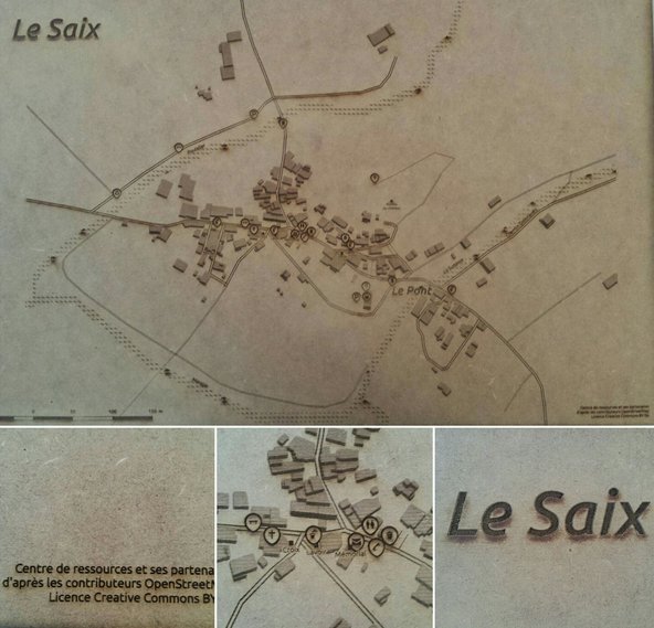
Jean-Christophe Becquet produces wooden maps with laser cutter 1 | © OpenStreetMap Mitwirkende CC-BY-SA 2.0 | © CC-BY SA
Mapping
- François Lacombe published a presentation on the topic, “Mapping of energy distribution networks”.

- User Jothirnadh explains how to edit a road segment while preserving route relations. His diary entry provides plenty of details and clear screenshots for each step.
- Michał Brzozowski posts some statistics about MAPS.ME edits. He remarks how power users fix many editing mistakes, but devote too much time and resources that could be otherwise applied on OSM improvements. Roland Obricht expresses appreciation for MAPS.ME edits.
- Yuri Astrakhan aka nyurik released a video on the topic “OSM+Wikidata”. More information on the wiki.
- Tijmen Stam suggests to introduce a tag
man_made=tunnelequivalent to the widely-usedman_made=bridge. Responses are positive and include suggested use-cases. - In Talk-ES user dcapillae mentions (automatic translation) a conflict happening in Galicia, North-West of Spain when someone decided to “close” a note. This practice is discouraged by many.
- Vincent Privat has summarized the suggestions from the SotM-FR concerning “indoor mapping” in a ticket.

Community
- The OSGeo-Live team is looking (automatic translation) for a maintainer of JOSM and Mapnik, in order to keep them as part of the Live-DVD. Astrid Emde provides detailed information on tasks and expected workload.
Additional help is needed to compile new documentation based on LearnOSM material. You’re welcome to contribute, ideally before July 3rd. - Creator13 collected a set of weird errors in French land registry. Despite these mismatches, he is glad that the dataset’s import saved a great amount of manual editing.
- GOwin compares OSM and Google Maps “glitches” in four areas of the world. He identifies OSM’s strength in community involvement versus centralised map management and cites Kibera project as a great example of map maintenance done by local people.
- PlacesForBikes used OSM data to compare bike networks in 299 cities across the U.S. The analysis aims to identify whether bikers can travel on low-stress segments of the bike network, and unveiled interesting findings.
- Members of the Russian community (automatic translation) travelled to Tula in order to map together.
- People for Bikes’, “Bike Network Analysis” gave Chicago a low score, but this is strongly related to the model and assumptions underlying the analysis itself. Both the data and the analysis are open: geodata comes from OSM and U.S. Census, while the analysis’ source code is available online.
- Edward Betts presents a tool to add Wikidata tags to OSM elements, and provides a summary of its functionality and usage.
- Bryan Housel is looking for translators for the iD editor.
 (automatic
  (automatic
 Events
- At SotM-FR, Michaël Louchin introduced LizMap, an integrated tool to create maps using QGIS and publish them online.
- The second edition of “l’université d’été développement de logiciel libre et open source (UDOS)” is taking place from June 28th to 30th in Digne-les-Bains, France. Among others, there are workshops on OpenLayers3, LeafletJS and OpenStreetMap with Overpass API.
- The Regionalverband Ruhr wants to convert its cross-city map work, which is in part OSM-based, and is looking (OSM-wiki) to communicate with the community. For several years, the RVR provides high-resolution aerial photographs for mapping.
- Stefan Keller will be talking about “Using OpenStreetMap for Tourism and Transport“ at the Opendata.ch (June 27, Luzern Switzerland) in the track, “Open Tourism & Transport Data“.
- Julien Coupey shares the presentation on Vehicle Routing Open-Source Optimization Machine he did for the State of the Map France 2017.
Humanitarian OSM
- The Humanitarian OpenStreetMap Team (HOT) has recently signed a cooperation agreement with the International Organization for Migration (IOM), the UN’s Migration Agency. Both organisations agreed to work closer together in the time of need, with the shared commitment to defending the rights and well-being of refugees, forcibly displaced communities and migrants.
- OpenStreetMap Togo extends (automatic translation) the Open Source Tour to Sotouboua municipality, where it has organised a OSM introduction for development agents (associations, NGOs and public service personnel).
Maps
- “La Dépêche” published an OSM-based interactive map to display the results in every district for the French parliamentary elections.
- Jean-Christophe Becquet presents on the French mailing list the project Cartosaixy. The main objectives: encouraging and animating the contribution to digital commons in rural areas, valuing free data by producing custom maps for the needs of small municipalities and experimenting with an innovative method of producing wooden maps with a laser cutter.
- Sarah Hoffmann, aka Lonvia, the maintainer of Waymarked Trails, announced a collaboration with OpenTopoMap.
switch2OSM
- DoorDash recently updated their application and are using Mapbox to let their customers track couriers, food delivery and much more.
- The NZZ shows all stages of “tour de Suisse” – of course OSM based. 😉
Licences
- OSM-legal mailing list answers a question regarding OSM data processing for routing calculations on a private machine for commercial purposes.
- Seán Lynch, creator of OpenLitterMap, asks OSM-legal mailing list for advice on terms and conditions, and liability of the site in case the user gets injured while mapping litter.
Software
- Mapbox Streets now supports Arabic and Portuguese languages, making their maps more accessible to 300 million internet users and contributing back to Wikidata and OpenStreetMap.
Programming
- The Qt Automotive Suite (Qt 5.9) now ships with vector-based maps (provided by Qt Location Mapbox GL plugin) and APIs for navigation, customized design and the ability to layer in your own data.
Releases
| Software | Version | Release date | Comment |
|---|---|---|---|
| Kurviger Free * | 10.0.28 | 2017-06-05 | Some enhancements. |
| guide4you | 2.0.1 | 2017-06-06 | Many changes, please read release info. |
| Naviki Android * | 3.60.1 | 2017-06-06 | Bugfix release. |
| Magic Earth * | 7.1.17.23 | 2017-06-07 | Many changes. Please read release info. |
| MapContrib | 1.8.2 | 2017-06-07 | Bugs fixed. |
| Mapillary iOS * | 4.7.0 | 2017-06-08 | Six new features and enhancements. |
| Mapbox GL JS | v0.38.0 | 2017-06-09 | One new feature, 11 bugs fixed and five development workflow improvements. |
| iD | 2.2.2 | 2017-06-12 | Many changes, please read release info. |
| Komoot Android * | var | 2017-06-12 | No infos. |
| Komoot iOS * | 9.1.2 | 2017-06-12 | Design of the komoot collections completely reworked, improved tour planning, reduced storage space. |
| OpenLayers | 4.2.0 | 2017-06-12 | Many changes, please read release info. |
| SQLite | 3.19.3 | 2017-06-18 | Bugfix release. |
Provided by the OSM Software Watchlist. Timestamp: 2017-06-13 00:32:52+02 UTC
(*) unfree software. See: freesoftware.
Mapbox’s mobile Navigation SDKs for iOS and Android have released big updates iOS (0.4.0) and Android (0.3.1). These will now give the tools that you need to add turn-by-turn navigation to your app or build a completely custom navigation app from scratch.
OSM in the media
- Ulrich Waltemath created (automatic translation) a database of bus stops for Harz district, Germany. He added precise locations to OSM, agreed, however, to share the database (complete with pictures) with the bus transport company for internal use only, at least for now.
Other “geo” things
- The Economist reviews the landscape of digital cartography for consumers, OSM and related projects are mentioned as an alternative to Google Maps.
- ISPRS’ 4th International Workshop on GeoInformation Science will take place in Safranbolu, Turkey, on the 14th and 15th of October 2017. The workshop will focus on multi-dimensional and multi-scale spatial data modeling. Papers can be submitted until the 15th of July.
- Mapillary hosted a blog post from Harriette Stone about post-earthquake survey methods. She listed pros and cons of data collection with cars, by foot or with drones, and suggests how to mitigate downsides of each method.
- Viae Romanae Maiores – Tabula reticuli: main roads of Ancient Roman Empire, rendered subway-style.
Upcoming Events


Note: If you like to see your event here, please put it into the calendar. Only data which is there, will appear in weeklyOSM. Please check your event in our public calendar preview and correct it, where appropriate.
This weeklyOSM was produced by Anmaca, Anne Ghisla, Nakaner, Peda, Polyglot, Rogehm, SK53, SeleneYang, YoViajo, derFred, jcoupey, jinalfoflia, juanblas09, vsandre, wambacher.