22/10/2019-28/10/2019
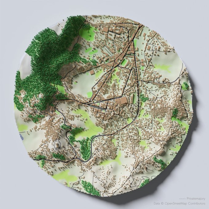
OSM-data + Blender + QGIS + … + creativity by Dolly Andriatsiferana
1 | © Dolly Andriatsiferana(@privatemajory) – Map data © OpenStreetMap contributors
Mapping
- Jean-Louis Zimmerman poses an ontological challenge for OSM tagging. How do you describe a tourism direction sign (fingerpost) with dynamic digital panels which rotate?
- The tag
highway=mini_roundabouthas been used nearly 52,000 times and was documented 11 years ago. Florian Lohoff came across a mini_roundabaout in OSM and suggests deprecating the tag, one which he hadn’t used before. This started a lengthy discussion thread on the tagging mailing list where you can learn the background and a lot of country-specific regulations. - The tagging of markers for utility services, such as gas and water pipes, service valves, power lines, hydrants and many more, has been approved. As usual the documentation moved from the proposal site to Key:marker in the OSM wiki.
- Mateusz Konieczny filed an issue on GitHub for the iD editor to reverse the disputed decision of the iD maintainers to let the iD validator recommend replacing
crossing=zebrawithcrossing=marked. This is a particular issue in the UK, where the tag originated, and where it has a precise legal meaning. The GitHub issue was closed and further comments were ignored. - Andrew Wiseman of Apple announces on several mailing lists that they had refreshed MapRoulette challenges with new data, and added more countries.
- Nuno Caldeira writes about how Portugal is validating parks with a MapRoulette mission to check for fake parks added by Pokémon GO players. It turns out that mis-translation and differences between Portuguese spoken in Brazil and Portugal have also contributed to mistagging of parks.
- Fanfouer’s “Line management” proposal aims to add information on how lines such as power lines are arranged on a support, such as a pole.
- Blog.dedj has given a visual explanation of how to use the Tasking Manager
 (automatic translation) to manage a project and break down group work.
 - Access tags, the use of the value “yes” vs “designated” and the “last mile” mapping of several logistic companies are causing discussions around the world. SomeoneElse explains his personal view on these topics in his user diary, which is — as he points out — very “England and Wales” centric.
 (automatic
 Community
- Kathmandu Living Labs reported the findings of their Digital Internship and Leadership (DIAL) program in an article in the Journal of Open Geospatial Data, Software and Standards. The program engaged undergraduate students and recent graduates from Nepal in a remote internship program to map rural Nepal.
- The responsive style “Air3” created by user Negreheb has been set as the default style by the administrator of the OSM forum, so visitors can also view the forum on their smartphones. Feedback is highly appreciated. Registered users can select the Air3-style at Profile->Display->Styles.
- The Malian website WoManager interviewed (automatic translation) Nathalie Sidibé from OpenStreetMap Mali. In the interview Nathalie shares challenges she came across in her young life as a Malian woman, and her future ambitions.
- Youthmappers have published their third quarterly newsletter of 2019. They welcome nine new chapters from universities in Bangladesh, Tanzania, Ethiopia, USA and Uganda, and share news of several mapping projects done by Youthmappers chapters all over the world.
OpenStreetMap Foundation
- A draft working document on the OSMF Microgrant scheme has been made available. Michael Reichert has already made some detailed comments on this draft.
- OSMF’s Membership Working Group explains the possibilities for those who can not afford the OSMF membership fee or alternatively have no way to send the OSMF membership fee. The post points to available information on the Fee Waiver Program and also to ways you can help people from your community become members of the Foundation.
Events
- If you have not yet attended a State of the Map this year, you still have the chance to catch up with a trip to New Zealand. The FOSS4G SotM Oceania will take place on 12 to 15 November 2019 in Wellington.
- On his WhatOSM blog, Ilya Zveryev reflects (automatic translation) on aspects of his talk at State of the Map Southeast Europe, “OpenStreetMapS”, on the consequences of regional variability in tagging approaches.
- OpenStreetMap DRC and MapBox held training (automatic translation) about MAPBOX ATLAS on 17 and 18 October. MAPBOX ATLAS is an offline mapping system for certain MapBox mapping tools. Local OpenStreetMap members Claire Halleux and David Kapay participated, as did two employees of the Ministry of Health who will use the tools in the fight against epidemics.
- The State of the Map Africa organising committee shares details about the conference in their blog. State of the Map Africa 2019 will take place in Abidjan and Grand-Bassam, Ivory Coast from the 22 to 24 November.
- Also State of the Map LatAm 2019 is looming. Latin Amercia’s main OSM event will take place from 14 to 16 November 2019 in Encarnación, Paraguay. Further details can be found in the OSM wiki (automatic translation).
 (automatic
  (automatic
 Humanitarian OSM
- Russell Deffner announced this year’s GeoWeek during the week of 11 to 16 November 2019. With partners such as the Climate Center, International Federation of Red Cross and Red Crescent Societies (IFRC) reference center, the events will be about completing tasks for mappers and validators related to climate change and extreme weather events.
- Ramani Huria, a community-based mapping project in Dar es Salaam, Tanzania that creates highly accurate maps of the most flood-prone areas of the city, features in the Collective Intelligence Design Playbook written by Nesta as an example of taking action to combat climate change and impact through collective intelligence.
- Nicholas Marchio highlights in an article in phys.org that the creation of the millionneighborhoods map “is a significant step toward locating where critical urban services are needed most”.
Education
- At DINAcon, the conference for digital sustainability, the Dinacon Awards presented five outstanding projects on Friday, 18 October in Berne. OpenSchoolMaps won in the category “Best Education Project”. A decisive point for the jury was obviously the possibility of feedback. OpenSchoolMaps is a small project to promote open maps and map data, including OpenStreetMap. It was founded by Prof. Stefan Keller. Also, computer science students of the university for technology Rapperswil helped.
Maps
- [1] Dolly Andriatsiferana presented a self-made map of their hometown, Fianarantsoa, on Twitter.
- The Transport & Development Policy Institute (ITDP) and the Brazilian Cyclists Union (UCB), two civil society organisations, have jointly created the CicloMapa platform to view cycling maps of Brazilian cities, with data mapped in OSM.
Open Data
- Maurizio Napolitano pointed on Twitter to a paper on the International Society for Photogrammetry and Remote Sensing’s website titled “Exploratory study of urban resilience in the region of Stuttgart based on OpenStreetMap and literature resilience indicators“.
- The Open Data Institute published a Collaborative Data Guidebook to help collaborative projects such as OSM and Wikidata with their data maintenance.
Licences
- Élisée Reclus tweets: “The @DeutschePostDHL uses #OpenStreetMap uniquely in its location search, but attributes #HERE”. He can recognise it because of a trap street accidentally created by himself. OSMF and FOSSGIS are now required to refer to our licence conditions.
 He can
 Programming
- Tomas Kasparek wants to create a map for the Czech Republic with old OSM data. While he has no issues with data back to October 2007, he has problems dealing with data before and asks for help.
Releases
- The iD editor has been updated to v2.16.0. The release notes highlight support for objects which were detected in Mapillary images and you can track changes while editing. You can now use this version on the main map.
- Joseph Eisenberg announced the release of v4.24.0 of the OpenStreetMap Carto stylesheet. Waterways as well as river and canal areas are now a bit darker. The new version also fixes the rendering of water body labels on nodes and deprecate the rendering of
waterway=wadi. There are more changes which he mentioned in his blog post or can be found in GitHub. - Version 3.10 of QGIS is now available for download. This version shows the 3D length for an identified 3D linestring, brings several labelling, symbology and rendering improvements and adds new 3D features, including a 3D On-Screen Navigation. The full list of improvements can be found in the changelog below the list of sponsors.
Did you know …
- Datawrapper offers an Enriched Map service using OSM in the background. This map inserted in a news item by Radio-Canada shows OSM attribution. We also reported about the Datawrapper Map Locator service in weeklyOSM 430.
- … the project resiliencymaps.org which harnesses the richness of OpenStreetMap for earthquake risk modelling.
- … Taginfo, the site which allows exploration of which keys and tags are in use on OSM. A number of local versions exist too.
Other “geo” things
- The 118-year-old listed Danish lighthouse Rubjerg Knude Fyr threatened to slide into the sea. The lighthouse was moved on rails and brought to safety by an elaborate procedure. The public interest was great. The move was, of course, recorded on OSM.
- No translation
- OpenStreetMap Cameroun calls on twitter for applications for the GeOsm project. The selected applicants will lead the deployment of national spatial data infrastructure based on OpenStreetMap, like Geocameroun does in Cameroon. The project is searching for representatives from all five subregions of the continent of Africa.
- Unexpected mobile roaming charges hit Russian scientists studying bird movements. SMS messages from a tracking device attached to an eagle were queued and dispatched en mass when the bird crossed borders into Iran and Khazakstan.
- It’s not just OSMers who nit-pick about the difference between bars and pubs. El País English edition carries an interview with Amadeo Lázaro owner of the Casa Amadeo “Los Caracoles” pub in Madrid. In his view, what separates a bar from a pub in Spain is that bars have chairs, pubs only stools.
- Climbing Uluru, a monolith in the desert south of Alice Springs, Australia, is no longer allowed. Violating both the sacred place of indigenous people and the consequent ban is now illegal.
Upcoming Events
| Where | What | When | Country |
|---|---|---|---|
| Dhaka | State of the Map Asia 2019 | 2019-11-01-2019-11-02 |  |
| Brno | State of the Map CZ+SK 2019 | 2019-11-02-2019-11-03 |  |
| Brno | Brněnský listopadový Missing maps mapathon na konferenci OpenAlt | 2019-11-02 | |
| Toronto | Toronto Mappy Hour | 2019-11-04 |  |
| Grenoble | Atelier Contribuer avec Mapillary | 2019-11-04 |  |
| London | London Missing Maps Mapathon | 2019-11-05 |  |
| Stuttgart | Stuttgarter Stammtisch | 2019-11-06 |  |
| Helsinki | Missing Maps Mapathon at Finnish Red Cross – Nov 2019 | 2019-11-07 |  |
| Bochum | Mappertreffen | 2019-11-07 | |
| San José | Civic Hack & Map Night | 2019-11-07 |  |
| Montrouge | Rencontre mensuelle des contributeurs de Montrouge et alentours | 2019-11-07 | |
| Ulmer Alb | Stammtisch Ulmer Alb | 2019-11-07 | |
| Dortmund | Mappertreffen | 2019-11-08 | |
| Kameoka | 京都!街歩き!マッピングパーティ:第14回 鍬山神社 | 2019-11-10 |  |
| Budapest | OSM Hungary Meetup reboot | 2019-11-11 |  |
| Taipei | OSM x Wikidata #10 | 2019-11-11 |  |
| Lyon | Rencontre mensuelle pour tous | 2019-11-12 | |
| Salt Lake City | SLC Mappy Hour | 2019-11-12 | |
| Nitra | Missing Maps Mapathon Nitra #4 | 2019-11-12 |  |
| Wellington | FOSS4G SotM Oceania 2019 | 2019-11-12-2019-11-15 |  |
| Hamburg | Hamburger Mappertreffen | 2019-11-12 | |
| Munich | Münchner Stammtisch | 2019-11-13 | |
| Berlin | 137. Berlin-Brandenburg Stammtisch | 2019-11-14 | |
| Nantes | Réunion mensuelle | 2019-11-14 | |
| Encarnación | State of the Map Latam 2019 | 2019-11-14 |  |
| Niš | Missing Maps Mapathon Niš #1 | 2019-11-16 |  |
| Hanover | Stammtisch | 2019-11-16 | |
| Cologne Bonn Airport | Bonner Stammtisch | 2019-11-19 | |
| Reading | Reading Missing Maps Mapathon | 2019-11-19 | |
| Lüneburg | Lüneburger Mappertreffen | 2019-11-19 | |
| Prešov | Missing Maps Mapathon Prešov #4 | 2019-11-21 | |
| Grand-Bassam | State of the Map Africa 2019 | 2019-11-22-2019-11-24 |  |
| Cape Town | State of the Map 2020 | 2020-07-03-2020-07-05 |  |
Note: If you like to see your event here, please put it into the calendar. Only data which is there, will appear in weeklyOSM. Please check your event in our public calendar preview and correct it, where appropriate.
This weeklyOSM was produced by Elizabete, Jorieke V, Nakaner, NunoMASAzevedo, PierZen, Polyglot, Rogehm, SK53, Softgrow, SunCobalt, TheSwavu, YoViajo, derFred.