04/06/2019-10/06/2019
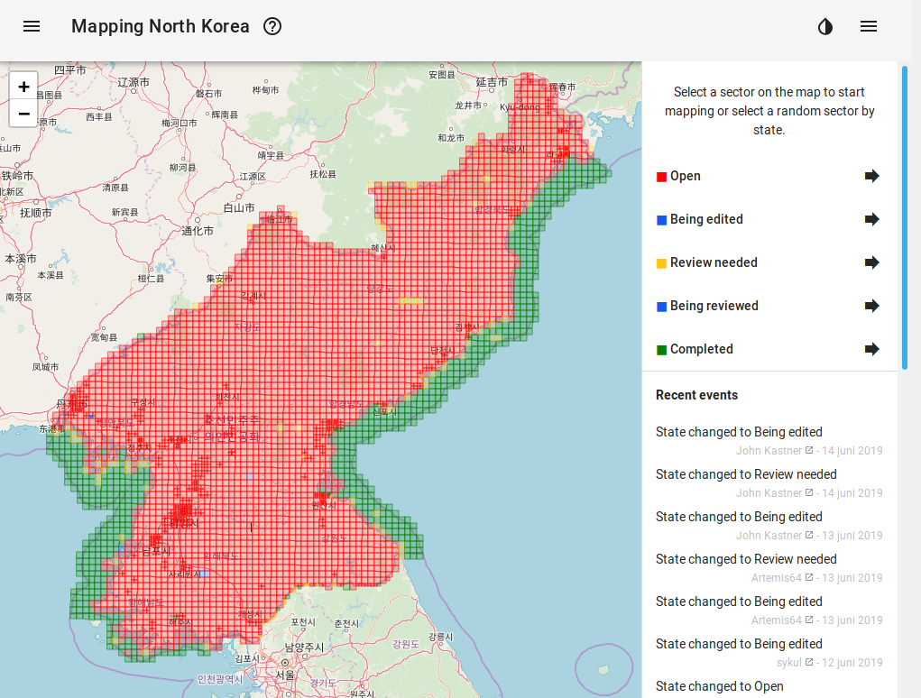
Mapping North Korea a new project from Maarten van den Hoven 1 | Map data © OpenStreetMap contributors, ODbL
Mapping
- Jean-Louis Zimmerman tweets
 a few unusual curiosities which may challenge OSM mapping and tagging. (automatic translation)
 - Joseph Eisenberg has posted his proposal for the tag
waterway=tidal channelto the tagging mailing list for discussion. It is based on a discussion that took place in September 2018 to map natural tidal waterways. - The OSM mapper Simon Legner reported (translation) on the Talk-at mailing list that he added the new layers of the Austrian government’s Open Data portal (OGD) to the editor layer index. He describes more about it on his github page.
- [1] Mapping North Korea is a new project from Maarten van den Hoven to remotely map North Korea, with a Tasking Manager style web interface.
- In order to be able to help people in crisis areas quickly, helpers depend on high-quality maps. For many areas, these maps must first be produced. In doing so, Doctors Without Borders is supported by modern technology – and by thousands of volunteers. On 25 June 2019 from 19:00 – 22:00, meet interested people for a Missing Maps Mapathon at Wikimedia in Berlin.
 a few unusual curiosities which may challenge OSM mapping and tagging. (automatic
 Community
- Nicolas Chavent published a Twitter moment about two weeks of OSM and free Geomatics training in Brazzaville (Congo) targeted to the local OSM community and stakeholders from the research, development and local authorities. The courses were facilitated with the help of members of Congolese communities and a Togolese mapper with the support of the International Organisation of Francophonie (OIF).
- On the mailing list OSM-talk the question was asked whether there are volunteers who want to organise a discussion forum at the upcoming SotM about the OSM Editor iD. However, a suggestion was made that it is not a good idea to hold a „tribunal” on iD, but that it would be better to collect ideas by September 1st and then discuss them.
- The OSM user Joseph Eisenberg asked on the mailing list OSM-talk whether the element
data itemon OSM Wiki pages should be used for description texts. The reason for this is that he found no or only very short descriptions for the tags,natural=peninsulaandnatural=isthmuson the wiki pages. When editing the wiki pages he could not find an element for the description and was referred to the element data item by other OSM users. Eisenberg also says that the wiki page for the element is very confusing and therefore its use is not clear to him. - A discussion (translation) about the mapping of „unpacked” stores on the German forum, previously tagged with
bulk_purchase, was followed by a discussion (translation) on the French forum on the same topic, but independently of each other. Now new tagging is discussed together in English under the heading „Tag[ging] shops accepting that customers bring their own containers”.
Imports
- HOT have set up a Tasking Manager for computer vision imports.
OpenStreetMap Foundation
- The minutes of the meeting of the OSMF Data Working Group on 22 May 2019 have been published.
Humanitarian OSM
- The website geospatialworld has published an article about the Missing Map project. It introduces the project and its goals.
- Intel Folsom hosted a mapathon with the Missing Maps Project. Estimated attendance was 56 mappers, plus 2 volunteers from the Red Cross and 1 volunteer from Intel to answer their questions. You can read more here.
Maps
- Said Turksever tweeted about ICT4Society in Turkey, a project using OSM and Mapillary to help improve social inclusion for people with disabilities, and links to the resulting map.
Licences
- Following a long discussion with Facebook and their map suppliers (Mapbox), Nuno Caldeira asked the Board of OSMF about terminating Facebook’s rights under ODbL. As source of his request he mentioned chapter 9.4 c) of the ODbL. This follows a long discussion about attribution of OSM in February and March this year on the main „talk” list.
Software
- K_sakanoshita published (Twitter, Facebook) new version of „Machi-aruki Map maker„, used for creating printed maps for disaster planning etc. New features are now available to add cafes and restaurants, fire hydrant icons and labels.
Programming
- Quincy Morgan suggests in a GitHub ticket that iD from version 3.0 should become a general GeoJSON editor.
Releases
- In the new release of OsmAnd 2.80 (iOS), Mapillary photos are displayed for navigation, as is already the case on Android. In addition to performance improvements there were many other adjustments. You can read more about this in OsmAnd’s blog.
Did you know …
- … a few lines of code with the 3-D Tool 3D OSM Buildings lets us rotate a panoramic view.
Other “geo” things
- The longest glass floor bridge in the world was recently opened in East China as a new attraction in the „Huaxi World Adventure Park” at the Great Wall of China. With a length of 518 m it replaces the previous record holder (488 m). Here’s where you can find this on OSM.
- Margaret Lee describes in Mapbox’s blog „The route from a blank map to a live map”.
- Malvika Mahesh, a research intern of the Observer Research Foundation, writes in his article „Drawing Lines On The Internet: Border Conflicts And The Politics Behind Digital Maps” on the different treatment of borders in digital maps. He also praises OpenStreetMap’s „on the ground” rule (see also OSM’s Disputed Territories (PDF) policy – itself not always accepted across the board in OSM) , and criticises Google’s current approach. An interesting link from that article is a map summarising worldwide disputes.
- World Environment Day took place on 5 June. A post at the University of Heidelberg’s GIScience News Blog links to the global OSM-based climate protection map, with a call to contribute to climate protection through more sustainable lifestyles.
- The changes in Berlin from being a car-friendly to a bicycle-friendly city can be seen at FixMyBerlin, where the current state of cycle-friendliness is also displayed.
- BMW published (translation) „safety-relevant traffic data”, collected by BMW vehicles, under the CC-BY-NC-SA license, which excludes commercial use, but which a BMW press release incorrectly describes as „free”.
Upcoming Events
| Where | What | When | Country |
|---|---|---|---|
| Montpellier | State of the Map France | 2019-06-14-2019-06-16 |  |
| Essen | 5. OSM-Sommercamp und 12. FOSSGIS-Hackingevent im Linuxhotel | 2019-06-14-2019-06-16 |  |
| Kyoto | 京都!街歩き!マッピングパーティ:第9回 光明寺 | 2019-06-15 |  |
| Dublin | OSM Ireland AGM & Talks | 2019-06-15 |  |
| Coimbra | Training School on Quality Control of OpenStreetMap Data | 2019-06-17-2019-06-19 |  |
| Cologne Bonn Airport | Bonner Stammtisch | 2019-06-18 | |
| Lüneburg | Lüneburger Mappertreffen | 2019-06-18 | |
| Rostock | Rostocker Treffen | 2019-06-18 | |
| Coimbra | Coimbra Mapping Party | 2019-06-18 | |
| Karlsruhe | Stammtisch | 2019-06-19 | |
| Leoberdorf | Leobersdorfer Stammtisch | 2019-06-20 |  |
| Rennes | Préparer ses randos pédestres ou vélos | 2019-06-23 | |
| Bremen | Bremer Mappertreffen | 2019-06-24 | |
| Angra do Heroísmo | Erasmus+ EuYoutH OSM Meeting | 2019-06-24-2019-06-29 | |
| Salt Lake City | SLC Map Night | 2019-06-25 |  |
| Montpellier | Réunion mensuelle | 2019-06-26 | |
| São Paulo | OpenStreetMap no MundoGeo Connect | 2019-06-26 |  |
| Lübeck | Lübecker Mappertreffen | 2019-06-27 | |
| Mannheim | Mannheimer Mapathons e.V. | 2019-06-27 | |
| Düsseldorf | Stammtisch | 2019-06-28 | |
| Kyoto | 幕末京都オープンデータソン#11:京の浪士と池田屋事件 | 2019-06-29 | |
| Sakai | 百舌鳥古墳群マッピングパーティ | 2019-06-30 | |
| Žilina | Missing Maps mapathon Zilina #5 at Faculty of Management Science and Informatics University of Zilina | 2019-07-02 |  |
| Cologne | Köln Stammtisch | 2019-07-03 | |
| Stuttgart | Stuttgarter Stammtisch | 2019-07-03 | |
| Essen | Mappertreffen | 2019-07-04 | |
| Bochum | Mappertreffen | 2019-07-04 | |
| Nantes | Réunion mensuelle | 2019-07-04 | |
| Dresden | Stammtisch Dresden | 2019-07-04 | |
| Ivrea | Incontro mensile | 2019-07-06 |  |
| Makati City | OSMPH × GrabPH Mapathon 1 | 2019-07-06 |  |
| Santa Fe | State of the Map Argentina 2019 | 2019-07-27 |  |
| Minneapolis | State of the Map U.S. 2019 [1] | 2019-09-06-2019-09-08 | |
| Edinburgh | FOSS4GUK 2019 | 2019-09-18-2019-09-21 |  |
| Heidelberg | Erasmus+ EuYoutH OSM Meeting | 2019-09-18-2019-09-23 | |
| Heidelberg | HOT Summit 2019 | 2019-09-19-2019-09-20 | |
| Heidelberg | State of the Map 2019 [2] | 2019-09-21-2019-09-23 | |
| Wellington | FOSS4G SotM Oceania 2019 | 2019-11-12-2019-11-15 |  |
| Grand-Bassam | State of the Map Africa 2019 | 2019-11-22-2019-11-24 |  |
Note: If you like to see your event here, please put it into the calendar. Only data which is there, will appear in weeklyOSM. Please check your event in our public calendar preview and correct it, where appropriate.
This weeklyOSM was produced by Nakaner, Polyglot, Rogehm, SK53, SomeoneElse, TheSwavu, derFred, geologist, jinalfoflia.