01/08/2024-07/08/2024
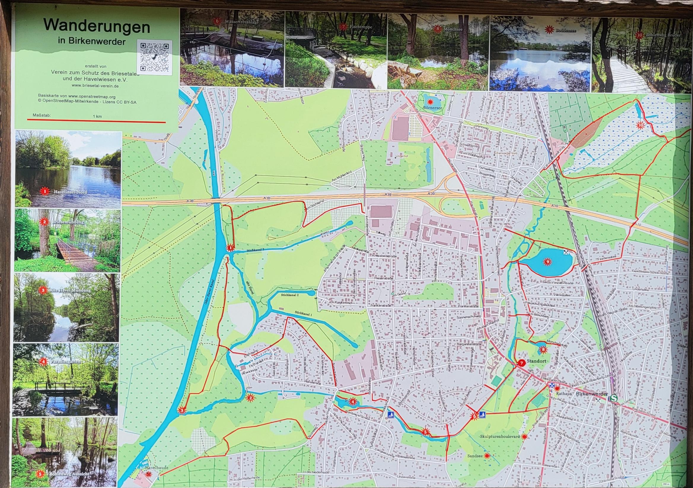
OSM-based hiking map in Birkenwerder, Germany [1] | Photo by Andreas Scherbaum © 2024 – © Verein zum Schutz des Briesetales und der Havelwiesen e.V. – map data © OpenStreetMap contributors
Mapping
- Andy Townsend questioned the default access tags for England and Wales and called for community input to refine these defaults. In another post, he examined the default access tags for urban and rural routes in England and Wales, and suggested improvements based on regional differences and gave specific example via overpass turbo queries.
- Comments are requested on:
Mapping campaigns
- HikaruKinkakuji is tackling the task of mapping 100 famous castles and a further 100 castles in Japan. During the latest event, Hikaru mapped Akita Castle
 ► for castle number 107. Hiraku started their project in 2015 ► and you can check on the project’s status ►.
 ►
►
Community
- FOSSGIS e.V. ►, Wikimedia Italia ►, and Colombian OpenStreetMap Community celebrated the 20th anniversary of OpenStreetMap, highlighting its evolution from a student project by Steve Coast in 2004 to the world’s largest open geospatial database, emphasising its collaborative nature, and the involvement of volunteers worldwide.
- On the OpenStreetMap Community forum, members have criticised MapRoulette for encouraging quick edits without proper verification, citing problems with careless mapping, the need for more accountability in challenges, and other suggestions for improving the platform’s gamification features to ensure thoughtful mapping.
- The UN Mapper of the Month for August is Taichi Furuhashi, MAPconcierge on OSM and professor at Aoyama Gakuin University in Japan.
- Tommy G D Charles talked about Sierra Leoneans’ contributions to the OpenStreetMap project, highlighting the importance of local mapping in addressing various challenges within the country, such as disaster response and urban planning, and emphasising community engagement and training initiatives to improve mapping skills.
 ►
► ►
► celebrated the 20th anniversary of OpenStreetMap, highlighting its evolution from a student project by Steve Coast in 2004 to the world’s largest open geospatial database, emphasising its collaborative nature, and the involvement of volunteers worldwide.
OpenStreetMap Foundation
- Arnalie Vicario informed OSMF members of two software issues affecting membership management: one bug resulted in some eligible voters not receiving ballots, and another resulted in incorrect active contributor memberships being granted. The Board and the Membership Working Group are investigating these issues and will notify affected members shortly.
Events
- Katja Haferkorn is looking ► for volunteers to staff an OpenStreetMap booth at WikiCon 2024, taking place from 4 to 6 October in Wiesbaden, Germany, with support available from FOSSGIS e.V. for travel and accommodation expenses. Interested parties should sign up on the dedicated wiki page ►.
- To celebrate 20 years of OpenStreetMap, IVIDES.org is releasing a 100% online and free series of workshops, for selected Brazilian universities. Raquel Dezidério tells us in her diary ► that two Amazon gift vouchers will be raffled off among the Brazilian participants. Each participant only needs to register once using the form to receive new notifications about the activities.
- OpenStreetMap’s 20th birthday party will be celebrated on or around Friday 9 August in cities all around the world. You can see the full list of events here.
- The Open Source Conferences for Coders, Learners and Promoters was held 3 and 4 August at the National Taiwan University of Science and Technology in Taipei, Taiwan. There were several sessions in the OpenStreetMap x Wikidata Open Content Track. A guest from Japan, Taro Matsuzawa, talked about the status of mapping in Japan, while Dennis Raylin Chen (Supaplex) talked about importing address datasets in 2024, and Feye Andal talked about YouthMappers.
- The State of the Map 2024 conference is calling for five-minute lightning talks on topics related to OpenStreetMap, with options for in-person presentations in Nairobi, Kenya, or pre-recorded online videos, with a deadline of Tuesday 20 August. If you missed the call for general and academic presentations at the State of the Map 2024, don’t worry – you can still showcase your project or map visualisation through the Call for Posters, which is now open with a deadline of Sunday 25 August.
- Inspired by the Paris 2024 Olympic Games, UN Mappers are proposing an exceptional competition: the UN Mappers Mapping Championship!
The mapper with the highest number of edits and the best mapping quality in the UN Mappers project in Jammu and Kashmir, Indian subcontinent, will secure first place, earning the title of UN Mapper of the Month. Test your mapping skills and climb to the podium.
 ►
► about importing address datasets in 2024, and Feye Andal talked about YouthMappers.
Maps
- Stamen discussed the implementation of motorway shields for Amazon Location maps (which use OpenStreetMap data with the attribution hidden), explaining the complexity of designing accurate and recognisable shields due to variations in data consistency and tagging conventions between countries. The article highlighted the process of creating these shields, the challenges posed by inconsistent data, and how these elements add valuable detail and context to map designs.
- The GeoPortal München presented ► an interactive map of 'cool places’ in München, Germany, to help residents find places with shade, water, and cooler temperatures, which is especially useful during heat waves.
- This interactive map visualises the birthplaces of 2024 Summer Olympics medallists, allowing users to explore the geographical distribution of athletes by region of origin. The map provides insight into which areas have produced the most medallists, offering a detailed view of regional sporting achievement.
OSM in action
- [1] Andreas Scherbaum has found an OSM-based hiking map in Birkenwerder, Germany, with correct attribution.
- Albileo has taken hundreds of photographs of aircraft. You can view their photo spots ► around Narita International Airport, Tokyo, Japan, on an OSM-based map.
Software
- William Edmisten reviewed six open source tools for querying OpenStreetMap data, including overpass turbo for web-based filtering, osm2pgsql combined with PostGIS for geospatial database queries, DuckDB’s experimental
ST_ReadOsm()function for direct file queries, QLever for RDF-based querying with SPARQL, Nominatim for geocoding based on textual input, and Pelias, which uses Elasticsearch for robust geocoding. William discussed the strengths, limitations, and setup procedures of each tool. - HeiGIT reported that the Initiative for Safer Roads has developed a digital school route planner , with the primary goal of improving road safety on school routes in Germany. The digital school route planner uses an OSM-based Germany-wide map of danger spots, which incorporates accident data from the police, reports from road users, and other factors, as well as HeiGIT’s openrouteservice API.
- Keir Clarke explored how OpenStreetMap data is being used to create immersive virtual reality experiences, such as osm4vr and VR Map, which allow users to navigate through a 3D world using OSM map tiles and building footprints.
- fltb’s first bi-weekly report on their OpenStreetMap public transport relational editor project detailed development progress, successful point and path rendering tests, and challenges such as integrating a custom user agent for tile requests, with plans to further develop the editor module for API communication.
Programming
- Try Catch Debug explained how to import OpenStreetMap layers into ArcGIS Server using JavaScript, detailing the steps to find OSM layers, use the ArcGIS API for JavaScript to integrate these layers, and customise ArcGIS Server with additional infrastructure layers.
- GeeksforGeeks explained how to use Leaflet to interact with maps in JavaScript, covering key concepts such as creating maps, adding markers, and implementing interactive features such as pop-ups and event handling, with sample code and step-by-step instructions.
- Hyumika’s OpenStreetMap plugin for WordPress, up to and including version 6.0.2, is vulnerable to SQL injection via the
tagged_filterattribute, allowing authenticated users with contributor level access or higher to execute additional SQL queries and potentially extract sensitive data. - c6tower(み) explained ► how to implement a web application for route searching using Valhalla and Leaflet, detailing the setup process using Docker, Python, and OpenStreetMap data, while demonstrating how to perform route searches and visualise the results on a map.
Releases
- Nominatim has released a new Wikimedia-based scoring file that uses data from Wikipedia and Wikidata to assign importance scores to places, allowing for more accurate geocoding, with the updated file now available in a streamlined CSV format.
Did you know …
- … OpenStreetMap has ’good practices’ guidelines?
- … that every three hours, the @rcityviews X (formerly Twitter) account will feature a randomly chosen city map from around the world using data from OpenStreetMap?
OSM in the media
- stern discussed ► the potential of outdoor apps, such as those using OpenStreetMap, to improve conservation efforts. DieBayern.de News highlighted ► that OSM often lacks specific information about protected areas. Collaboration between app developers and conservation authorities could improve data accuracy and help users avoid disturbing sensitive areas. By incorporating clear guidelines and temporary restrictions into maps, and using data from user interactions, apps can better manage ► visitor flows and support conservation through initiatives such as citizen science projects.
Other “geo” things
- Minnesota Governor Tim Walz, a former geography teacher and current US vice-presidential candidate, is passionate about maps and GIS, which he believes are critical to data-driven policymaking in areas such as education and public safety. He uses maps extensively to communicate with constituents and inform policy decisions, and criticises oversimplified red-blue political maps for their divisive effects. Walz emphasises the importance of GIS in translating visions of social justice into tangible results.
- Truevision Designer is a versatile tool for creating detailed maps for simulation, robotics and training, with tools for intersections, signal editing and exporting to platforms such as CARLA, with free and premium options available. Version 2024.8 introduced improved lane marking support, enhanced OpenDrive geometry imports, a new Super Elevation tool for realistic road slopes, and significant improvements to the junction creation process, including custom junction and connection tools.
Upcoming Events
| Where | What | Online | When | Country |
|---|---|---|---|---|
| Salt Lake City | OSM Utah 20th Birthday Happy Hour | 2024-08-10 |  | |
| Localidad Teusaquillo | 20 años OpenStreetMap – GeoBeer en Beeя del Gran Estación, Bogotá | 2024-08-10 |  | |
| Obio/Akpor | Map Nigeria Mapathon Campaign and AI -Assisted Mapping Training | 2024-08-10 – 2024-08-11 |  | |
| Nairobi | Celebration of the 20th OSM Birthday in Kenya | 2024-08-10 | ke | |
| Thrissur | OpenStreetMap 20th Anniversary at Thrissur, Kerala | 2024-08-10 |  | |
| Bengaluru | OSM Bengaluru Mapping Party | 2024-08-10 | | |
| Karlsruhe | Mappingparty zum 20. OSM-Geburtstag | 2024-08-10 |  | |
| London | London OSM Birthday Party | 2024-08-10 |  | |
| Denkada | MVGR OSM 20th Anniversary Mapping Party | 2024-08-10 | | |
| Manhattan | OSM 20th Birthday New York City | 2024-08-10 | | |
| Москва | Moscow OSM 20th Anniversary Meetup | 2024-08-10 |  | |
| ბათუმი | 20 years with OpenStreetMap | 2024-08-10 | ge | |
| Localidad Teusaquillo | Cerveza por los 20 años de OSM | 2024-08-11 | | |
| Obio/Akpor | Map Nigeria Mapathon Campaign and AI -Assisted Mapping Training | 2024-08-10 | | |
| OpenStreetMap Online Mapping Party | 2024-08-10 | |||
| Vijayawada | Swecha AP OSM 20th Anniversary and Mapping Party with Kids and Adults | 2024-08-11 | | |
| Stuttgart | 20 Jahre OpenStreetMap: Stäffele-Mapping in | 2024-08-11 | | |
| Kollam | Openstreetmap Mapping & Birthday Celebration | 2024-08-11 | | |
| København | OSMmapperCPH | 2024-08-11 |  | |
| Rheinau | OSM Geburtstagsfeier am 11. August Badi Rheinau | 2024-08-11 |  | |
| Hamburg | Hamburger Mappertreffen | 2024-08-13 | | |
| Lorain County | OpenStreetMap Midwest Meetup | ✓ | 2024-08-15 | |
| München | Münchner OSM-Treffen | 2024-08-14 | | |
| Umuarama | [on-line]  20 anos de OSM #1 – Oficina do IVIDES.org para a UNIPAR (Brasil) 20 anos de OSM #1 – Oficina do IVIDES.org para a UNIPAR (Brasil) | 2024-08-16 |  | |
| OSMF Engineering Working Group meeting | 2024-08-16 | |||
| Sankt Augustin | OSM auf der FrOSCon Sankt Augustin | 2024-08-17 – 2024-08-18 | | |
| Hannover | OSM auf der Maker Faire Hannover | 2024-08-17 – 2024-08-18 | | |
| Варна | OpenStreetMap in Varna (на морето) | 2024-08-17 |  | |
| Hannover | OSM-Stammtisch Hannover | 2024-08-17 | | |
| Meerut | 1st OSM Meerut Mapping Party | 2024-08-18 | | |
| Sankt Augustin | Vortrag: 20 Jahre OpenStreetMap | 2024-08-18 | | |
| The Municipal District of Kilkenny City | Citizens Science and Linked Open Data | 2024-08-19 |  | |
| The Municipal District of Kilkenny City | Citizen Science: Kilkenny Heritage sites & Linked Open Data for Ireland’s National Heritage Week 2024 | 2024-08-19 | | |
| England | OSM UK Online Chat | 2024-08-19 | | |
| Santa Maria | [on-line] 20 anos de OSM #2 – Oficina do IVIDES.org para a UNIPAMPA (Brasil) | 2024-08-20 | | |
| Missing Maps London: (Online) Mid-Month Mapathon | 2024-08-20 | |||
| San Jose | South Bay Map Night | ✓ | 2024-08-21 | |
| Bonn | 178. OSM-Stammtisch Bonn | 2024-08-20 | | |
| Salt Lake City | OSM Utah Monthly Map Night – Mapillary Capturing! | 2024-08-22 | | |
| Lübeck | 145. OSM-Stammtisch Lübeck und Umgebung | 2024-08-22 | | |
| Rio de Janeiro | [on-line] 20 anos de OSM #3 – Oficina do IVIDES.org no III GSEA-UFRJ (Brasil) | 2024-08-23 | | |
| Karol Bagh Tehsil | 11th OSM Delhi Mapping Party | 2024-08-25 | | |
| Stadtgebiet Bremen | Bremer Mappertreffen | 2024-08-26 | |
Note:
If you like to see your event here, please put it into the OSM calendar. Only data which is there, will appear in weeklyOSM.
This weeklyOSM was produced by Michael Montani, Raquel Dezidério Souto, Strubbl, Supaplex, TheSwavu, barefootstache, derFred, isoipsa, mcliquid, miurahr, rtnf.
We welcome link suggestions for the next issue via this form and look forward to your contributions.
I found the attribution on the Amazon map: in the panel at the bottom of the page, scroll down to the very bottom, then click About, then click Attribution. That screen credits OpenStreetMap among several others. Whew!