12/10/2021-18/10/2021
OpenStreetMap France celebrated its 10th birthday [1] © OpenStreetMap France
Mapping campaigns
- The Planning Department of the Ministry of Education in Madagascar, in collaboration with the UNESCO International Institute for Educational Planning (IIEP-UNESCO) and UN Mappers, is seeking to map the full road network of the Vakinankaratra region to make sure that the journey to school for children can be as straightforward as possible. The road network produced will then be processed using the IIEP-UNESCO school catchment plugin to assess travel times. A mapathon open to everyone will be held next Wednesday 27 October.
Mapping
- Mapillary’s change from API version 3 to 4 has apparently resulted in changed photo IDs, which had been tagged in OSM on some objects with
mapillary=*. There is a discussion on the tagging mailing list about how to handle the tag in the future. Mateusz Konieczny proposes abolishing the tag if a changeover is not possible. - Sebastian asked
 > the talk-de mailing list how to correctly record hydrants with blue bordered signs and if there is an already established procedure.
 - DUGA humorously describes mapping practices that they believe are incorrect and offers better solutions, which are also welcomed to be discussed in the comments.
- Requests have been made for comments on the following proposals:
inlet=*for tagging the details of where the flow enters a culvert or pipeline.- Avalanche transceiver training zones for mapping areas where skiers can practice using their avalanche beacon.
- Voting has ended for the following proposals:
natural=fumarole, to map an opening in our planet’s crust, which emits steam and gases, was approved with 16 votes for, 0 votes against and 0 abstentions.landuse:secondary=*, for mapping multiple land uses in a single area, was not successful with 14 votes for, 23 votes against and 3 abstentions.headlight=*, for reflecting the legal requirement on some roads to use your headlights, was approved with 28 votes for, 1 vote against and 0 abstentions.foraging=*, to indicate whether or not foraging for plants/fruit/fungi etc. is permissible for a given location or plant, was approved with 11 votes for, 0 votes against and 3 abstentions.
- tffmh has reviewed the streets of Mühlheim an der Ruhr to make sure the
de:strassenschluessel(a street’s unique identifier) and etymology are correct.
 >
> 
Community
- arnalielsewhere shared the collaboration project: ‘Localization as an Inclusion and Participatory Enabler’, which aims to bridge the gap between language and accessibility of HOT Humanitarian Open Mapping resources. The project is in collaboration with local communities and contributors from Vietnam, Madagascar, and Mozambique, as well as the Open Mapping Hubs in the Asia-Pacific and East and Southern Africa.
- The HOT Open Mapping – Asia Pacific Hub is launching ‘She Leads and She Inspires’, a programme that will engage 100 women between December 2021 and June 2022.
- Volunteers are needed from all corners of the global OpenStreetMap community to participate in the OSMF Moderation Team to lead efforts to keep the lists safe, welcoming, and inclusive.
- Many user accounts were created in order to vote in the proposal to include cryptocurrencies into the payment tag, resulting in questioning whether it could be an issue or not and how the voting system could be reduced to absurdity through mass new user account creation.
- Valerio Bozzolan illustrated how he maps and locates veterinarians for rabbits 🐇 with an expansion of a proposal submitted in 2012 to detail veterinary tagging.
- Feye Andal reviewed her work as the Southeast Asia YouthMappers Ambassador in 2021. The number of chapters in the region grew from four to nine.
OpenStreetMap Foundation
- Allan Mustard, current chair of the OpenStreetMap Foundation board, announced that he will not be standing for re-election.
- On the OSMF-Talk mailing list, Dorothea Kazazi announced that questions to candidates in the next OSMF board elections can be submitted on a OSM wiki page until 2 November.
- The Openstreetmap Foundation Local Chapters and Communities Working Group (LCCWG) is inviting you to the Local Chapters and Communities Congress 2021 on 6 November.
- The Microgrants Committee has submitted a report on the trial run of the OSMF microgrants programme. Project reports by grantees are also linked off the same page.
Local chapter news
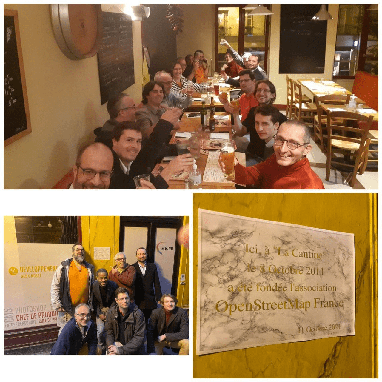
- [1] The France OSM community celebrated > the 10th anniversary of the foundation of OSM-FR with meetings linked by BigBlueButton. A special delegation visited the site of the meeting which created OSM France, and left a (temporary) plaque.
- The call for proposals of State of the Map US 2022 (1 to 3 April 2022 in Tucson, Arizona) is open until 17 December 2021.
 >
> 
OSM research
- Siddharth Joshi et al. have published an article in Nature Communications on a global assessment of rooftop solar photovoltaic’s potential for renewable electricity generation. The study used road and building data from OpenStreetMap.
Humanitarian OSM
- The HOT Disaster Services Team have shared an after action report on the activation in response to the Mediterranean Wildfires, sharing their internal assessment of how the activation was carried out.
- The HOT Quality Control and Assurance Working Group has started a Tasking Manager Project Gardening Process wiki page with the objective of defining the workflow for the administration of the Tasking Manager, specifically the oversight of projects. Phase 1 looks at archiving projects that no longer have a reason to remain active on the Tasking Manager.
Maps
- webkid have produced an OSM based map which shows the age of every building in Berlin using a public dataset. The map is used under the title – ‘Old or new building? So lives Berlin’ – on an interactive site of the Berliner Morgenpost.
- Aishworya Shrestha from Kathmandu Living Labs announced the launch of the Before-After Map Query tool and invited users to make maps of their own areas. This query tool shows data for a place at two different points in time. Its main objective is to compare how a particular area looks in two different years, side by side, and show local mapping efforts over a specific time period. Users must provide name and email details to be notified once the map is generated.
Software
- The Geo Data Merger is a desktop open source tool for merging data from csv, json, geo- and topojson files.
- During this year’s State of the Map, Davey Lovin (user mDav) introduced a webmap and quality assurance tool for long distance hiking trails. Superroute aims to gather together a community of hikers to maintain and improve the data quality of these trails.
- The A/B Street traffic simulator now lets you reimagine your city as it would be if designed for safe travel by bicycle. This extension of the project aims to show how such changes to the road network would impact travels citywide.
Programming
- HeiGIT and HOT have partnered together and extended the Humanitarian OSM Stats website to help relay mapping statistics to the public. It includes data, not only from HOT Tasking Manager projects, but also from all the other OSM contributors.
Did you know …
- … that it is possible to run Go Map!! on your Mac?
- … Organic Maps? Another offline map app using OpenStreetMap data, forked from MAPS.ME, it features no ads, no tracking, nor data collection.
Other “geo” things
- Google unnecessarily continues to censor part of Israel after receiving updated imagery from Airbus.
Upcoming Events
| Where | What | Online | When | Country |
|---|---|---|---|---|
| Черкаси | Open Mapathon: Digital Cherkasy | 2021-10-24 – 2021-11-20 | ua | |
| Budapest | Survey around the University of Óbuda (please vote!) | 2021-10-25 |  | |
| Hlavní město Praha | “50 years of MSF” mapathon with Missing Maps CZ community 2021 #6 | 2021-10-25 |  | |
| Code for Toyama City シビックテックナイト#33 参加できるデジタル地図づくり | 2021-10-25 | |||
| Bremen | Bremer Mappertreffen (Online) | ✓ | 2021-10-25 |  |
| San Jose | South Bay Map Night | ✓ | 2021-10-27 |  |
| Derby | East Midlands OSM Pub Meet-up : Derby | 2021-10-26 |  | |
| Bruxelles – Brussel | OpenStreetMap Belgium IRL meeting | 2021-10-26 |  | |
| Mapathon: United Nations for Madagascar | 2021-10-27 | |||
| Düsseldorf | Düsseldorfer OSM-Treffen (online) | 2021-10-27 | | |
| Decatur County | OSM US Mappy Hour | 2021-10-28 | | |
| [Online] OpenStreetMap Foundation board of Directors – public videomeeting | 2021-10-29 | |||
| Amsterdam | OSM Nederland maandelijkse bijeenkomst (online) | ✓ | 2021-10-30 |  |
| Prévessin-Moëns | Cartographie dans le Pays de Gex | 2021-10-31 |  | |
| [Online] OpenStreetMap Foundation – Board of directors and advisory board public videomeeting | 2021-11-02 | |||
| Greater London | Missing Maps London Mapathon | 2021-11-02 | | |
| Landau an der Isar | Virtuelles Niederbayern-Treffen | ✓ | 2021-11-02 | |
| Nordrhein-Westfalen | OSM-Treffen Bochum (November) | 2021-11-04 | | |
| OSM Local Chapters & Communities Virtual Congress | 2021-11-06 | |||
| Crowd2Map is 6! Join our party mapathon to learn more about our work.. | 2021-11-07 | |||
| 臺北市 | OSM x Wikidata Taipei #34 | 2021-11-08 |  | |
| Zürich | OSM-Treffen Zürich | 2021-11-11 |  | |
| Berlin | 161. Berlin-Brandenburg OpenStreetMap Stammtisch | ✓ | 2021-11-11 | |
| FOSS4G State of the Map Oceania 2021 | 2021-11-12 |
Note:
If you like to see your event here, please put it into the OSM calendar. Only data which is there, will appear in weeklyOSM.
This weeklyOSM was produced by Climate_Ben, Lejun, Michael Montani, Nakaner, Nordpfeil, PierZen, SK53, Strubbl, TheSwavu, YoViajo, arnalielsewhere, derFred, tordans.