05/07/2022-11/07/2022
Explore latest changes on OpenStreetMap [1] © tyrasd and rene78 | map data © OpenStreetMap contributors
Mapping
- Île des faisans / Isla de los Faisanes is an islet between Hendaye (France) and Irun (Spain) where negotiations took place for the marriage of Louis XIV and the Infanta of Spain. It is a condominium shared and jointly run by the two countries. The question of how to map such territories arose on talk-fr. The discussion mentioned
 > various examples but has identified no solution as yet.
 - Sarah Heidekorn presented a new entry in the ohsome Region of the Month series, a blog with many helpful guides for OSM mapping. This month is part two about hiking tags and explains the connection between said tags and user activity by using insights from the first post in the series.
- Requests have been made for comments on the following proposals:
crossing:markings=*for mapping the existence and style of pedestrian crossing markings.place_of_worship=lourdes_grottoto tag replicas of the original grotto at Lourdes, France.man_made=grottoa tag for human-made or human-altered caves, built as a landscaping element or attraction.
 >
> 
Community
- Schnapps number! The changeset numbered 123456789 was uploaded on 11 July by Daniel (user d1sr4n) from Komi Republic, who has contributed over 3.3 million changes so far and was Mapper of the Month of the Belgian OSM community in December 2021.
- mariotomo wrote on OpenStreetMap Community to express his concerns about the many mailing lists being subscribed to by weeklyOSM.
Local chapter news
- The OSMF Japan branch has extended aerial photo hosting > to the cities of Muroran and Osaka. Osaka City is the second dataset to be authorised under the Japanese Survey Act application.
 >
> Events
- SotM 2022 in Fierenze, Italy:
- Federica, from the SotM 2022 Florence organising team, is calling for pre-recorded Lightning Talks (5-minute talks), ‘in case you can’t make it to Florence’, by 12 August 2022 23:59:59 UTC.
- Participants of the Florence conference can register their Lightning Talks at the beginning of the conference on 19 August.
- The SotM working group is seeking a venue for SotM 2023.
Maps
Open Data
- Leonardo Gutierrez of Trufi Association discussed how ‘Digitising Active Transport’ is more than mapping bike routes and pavements (sidewalks); active transport solutions need OSM and open data that is relevant to the needs of the people who bike, walk, and make multimodal journeys. Video in Spanish; summary in English.
 how ‘Digitising Active Transport’ is more than mapping bike routes and pavements (sidewalks); active transport solutions need OSM and open data that is relevant to the needs of the people who bike, walk, and make multimodal journeys. Video in Spanish; summary in English.
Software
- Congratulations to the overpass turbo team on the 10th anniversary of this application, and for their constant efforts and improvements. On 16 Jul 2012, Martin Raifer committed the first version to GitHub.
- Stefan Keller informed us that two of his computer science students have developed an application called ‘OSM Wikidata Quality Checker‘ with the help of Sascha Brawer. The application checks existing links from OpenStreetMap to Wikidata. The errors found – for example invalid Wikidata entries in OpenStreetMap – are also sent to Osmose-QA with a suggested correction. The software processes the data worldwide on a weekly basis. Currently, a total of over 30,000 error notes have been found in nine categories. They are now looking for a place to host this data processing pipeline permanently.
- Natenom described in his blog how to include gradients when calculating routes using OsmAnd with and without the BRouter app installed.
 in his blog how to include gradients when calculating routes using OsmAnd with and without the BRouter app installed.
Programming
- Arne Hamann won the first prize at the NextGov Hackathon (€5,000) in May for developing new features for Nextcloud Maps, which uses OpenStreetMap data. His goal was to make the Maps applications collaborative. Previously, the functions were minimal and there was no way for them to interact with others. Thanks to his efforts, collaborative use of mapping is now possible in Nextcloud Maps.
- Trufi’s back-end expert, Sören Reinecke, provided a guided walkthrough for developers.
Releases
- Paul Norman announced the release of OpenStreetMap Carto v5.5.0. This is the default style sheet on the OSM website, which with this release, now renders mountain passes.
Did you know …
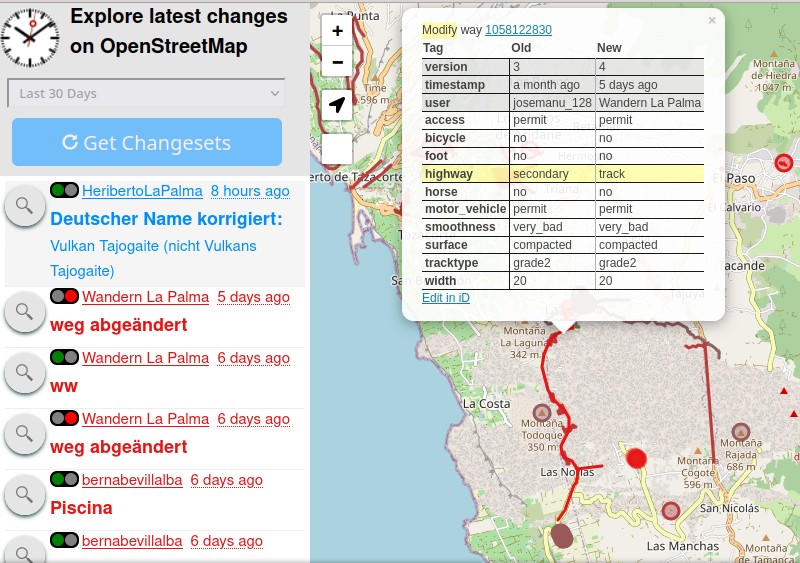
- [1] … that the changeset assessment tool ‘Latest Changes‘ has been updated? It helps you to check recent OSM changes within a certain cartographic boundary, for example your home town. The most relevant updates were a tag comparison table similar to achavi, a download button to fetch changesets, and a vandalism checker to find suspicious edits.
Other “geo” things
- alexkemp noticed that pictures uploaded to Mapillary cannot be downloaded via their site any more and links to pictures become invalid after some time. He is not happy about his discovery.
- A Twitter discussion triggered interest in maps printed on scarves. France Foulards will print > a map selection of France on a scarf for you from IGN data.
Upcoming Events
| Where | What | Online | When | Country |
|---|---|---|---|---|
| Windsor | Inaugural OpenStreetMap Windsor-Essex Meetup | 2022-07-15 |  | |
| Frankfurt am Main | FFM — Mapping public surveillance cameras | 2022-07-16 |  | |
| 臺北市 | 第三次 OpenStreetMap 街景踏查團工作坊 | 2022-07-17 |  | |
| OSMF Engineering Working Group meeting | 2022-07-18 | |||
| 153. Treffen des OSM-Stammtisches Bonn | 2022-07-19 | |||
| City of Nottingham | OSM East Midlands/Nottingham meetup (online) | ✓ | 2022-07-19 |  |
| Lüneburg | Lüneburger Mappertreffen (online) | 2022-07-19 | | |
| Washington | OSM US Mappy Hour | ✓ | 2022-07-21 |  |
| 1040 | OSM Wien Stammtisch | 2022-07-21 |  | |
| 大阪市 | ひがよどの街を世界にシェア #01 | 2022-07-23 |  | |
| 京都市 | 京都!街歩き!マッピングパーティ:第32回 妙心寺 | 2022-07-24 | | |
| Düsseldorf | Düsseldorfer OpenStreetMap-Treffen | ✓ | 2022-07-27 | |
| [Online] OpenStreetMap Foundation board of Directors — public videomeeting | 2022-07-28 | |||
| 臺北市 | COSCUP 2022 OpenStreetMap x Wikidata 聯合議程軌 | 2022-07-30 | | |
| Buenos Aires | 4a reunión bimestral de OSM Latam (organiza OSM Argentina) | 2022-07-30 |  | |
| MapRoulette Monthly Community Meeting | 2022-08-02 | |||
| Stuttgart | Stuttgarter Stammtisch | 2022-08-02 | | |
| London | Missing Maps London Mapathon | 2022-08-02 | | |
| Salt Lake City | OSM Utah Monthly Meetup | 2022-08-04 | |
Note:
If you like to see your event here, please put it into the OSM calendar. Only data which is there, will appear in weeklyOSM.
This weeklyOSM was produced by MatthiasMatthias, Nordpfeil, PierZen, SK53, Strubbl, Ted Johnson, TheSwavu, UNGSC_Alessia13, YoViajo, derFred.