16/05/2017-22/05/2017
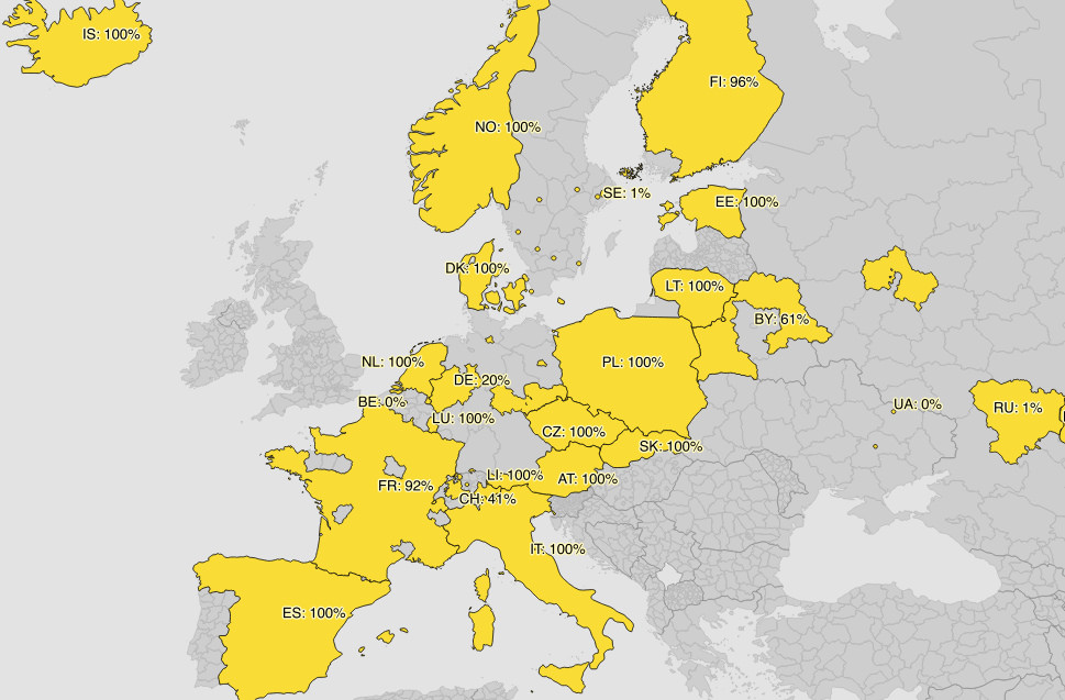
State of the OpenAddress data coverage in Europe 1 | © Michal Migurski © Mapbox © OpenStreetMap Contributors ODbL
Mapping
- Dieterdreist wrote a proposal on
aeroway=spaceport. The voting is open until May 30th. - Yo paseopor calls to use the traffic sign recognition of Mapillary in OSM as nodes to capture traffic signs.
- On the tagging mailing list, Dave F wonders about the existence of
toilets:wheelchairandwheelchair_toiletin the iD editor. After some discussion, he gets the information that a pre-selection for free texts information comes from Taginfo and thus can contain typos.
Community
- User Hakuch published WikiRever, a tool that looks up who inserted or deleted a specific phrase from an OpenStreetMap Wiki page. He claims that it is easier to use than Wikiblame. (automatic translation)
- The American Red Cross announces a job as “American Red Cross GIS Analyst” in Bogota, Colombia.
OpenStreetMap Foundation
- OSM France has applied for recognition as a regional representative of the OSM Foundation.
Events
- The Dresden OSM-Community is planning an OSM Summer camp on a weekend in August or September and is seeking expressions of interest (DE) before booking the venue.
Humanitarian OSM
- Geoffrey Kateregga writes in the HOT blog about the malaria elimination mapping campaign, in which youth mappers from five universities in Uganda mapped 800,000 buildings. The three most active users got a scholarship to the SotM Africa.
- The Jakarta Post reported on the collaboration of several humanitarian organisations to support disability and the poor in Indonesia.
- Rebecca Firth searches on the HOT mailing list for experienced mappers to validate tasks in the District of Salima, Malawi.
- C J Hendrix of the Centre for Humanitarian Data reported on the new automatic OSM exports for the HDX (Humanitarian Data Exchange), which were created in cooperation with HOT.
Maps
- Are you searching for geolocations of Wikipedia articles on the OSM map? Alex-7 created a web app.
- Black is beautiful: A bug in the latest carto style caused waterways with
intermittent=yesto be rendered in black instead of dashed blue. The issue has been solved.
switch2OSM
- Via Staziun is a project of the SBB and the Foundation My Handicap with the aim “to facilitate orientation at train stations: with current photos and information from all Swiss railway stations, collected and shared by other travellers”. The pictures are available in Mapillary but all other information is not available under a free and open license.
Open Data
- [1] Michal Migurski presents the OpenAdresses project on the Mapbox blog and garnishes it with some nice statistics.
Software
- A new Taginfo site for Japan has been setup, joining the other 12 country specific Taginfo sites. The site is operated by MIERUNE.
- Arun (PlaneMad) wrote a diary entry about StreetComplete, an app by Tobias Zwick (westnordost). It asks a user to complete things like street names, bus stops, street surfaces, house numbers and opening hours. As with attempts at “gamification” in the past there has been both praise and questions over the mechanism used. Suggestions or assistance are welcome at Github.
- The MapOSMatic instance by Hartmut Holzgraefe is now able to represent GPS tracks as an overlay on maps and shows preview pictures of the map layout configuration.
Programming
- The Mapbox Mobile SDK can be enhanced by plugins.
- Christoph Lingg asked whether there is an easier-to-use OSM data format other than PBF. He would prefer the data in GeoJSON. Jochen Topf explained in detail where the problems are and suggested his export-branch of osmium which can export to GeoJSON.
Releases
| Software | Version | Release date | Comment |
|---|---|---|---|
| GeoServer | 2.11.1 | 2017-05-19 | 37 bugfixes and some enhancements. |
| Traccar Client iOS | 4.2 | 2017-05-15 | Report by distance and angle. |
| Naviki iOS * | 3.59 | 2017-05-16 | Offline maps, Google login and some more bugs fixed. |
| Traccar Client Android | 4.3 | 2017-05-16 | No infos. |
| Kurviger Free * | 10.0.25 | 2017-05-17 | Address search and other improvements. |
| OpenMapTiles | 2.3.0 | 2017-05-17 | Minor bug fixes, tweaks and improvements. |
| Komoot Android * | 9.1 | 2017-05-18 | No infos. |
| MapContrib | 1.7.10 | 2017-05-19 | Display the localized version of the tag value in popup content. |
| Mapillary iOS * | 4.6.16 | 2017-05-19 | Fixed basemap bug that could result in empty map. |
| Maps.me Android * | var | 2017-05-19 | No infos. |
| QGIS | 2.18.8 | 2017-05-19 | No infos. |
| StreetComplete | 0.11 | 2017-05-21 | New languages: Malayalam, Czech, Portuguese (PT) |
| Komoot iOS * | 9.1.1 | 2017-05-22 | Tour planning revised and simplified, indication of a fitness level for route selection. |
| OpenStreetMap Carto Style | 3.3.1 | 2017-05-22 | Bugfix release. |
| SQLite | 3.19.0 | 2017-05-22 | 13 enhancements and six bugfixes. |
Provided by the OSM Software Watchlist. Timestamp: 2017-05-22 19:23:05+02 UTC
(*) unfree software. See: freesoftware.
OSM in the media
- João Pedro Leite blogs on GeekTime about the three map monopolists and why OpenStreetMap is a way out.
Other “geo” things
- Andy Dearing explains why open source GIS software is so important and a driving factor, especially in the IoT (Internet of Things) environment.
Upcoming Events
| Where | What | When | Country |
|---|---|---|---|
| Manila | San Juan City Mapa-thon by MapAm?re , San Juan | 29/05/2017 |  |
| Leuven | 2nd Leuven Monthly OSM Meetup | 31/05/2017 |  |
| Dusseldorf | Stammtisch Düsseldorf | 31/05/2017 |  |
| Dresden | Stammtisch | 01/06/2017 | |
| Avignon | State of the Map France 2017 | 02/06/2017-04/06/2017 |  |
| Lviv | Map Solutions 2017 | 03/06/2017 |  |
| Taipei | OSM Taipei Meetup, MozSpace | 05/06/2017 |  |
| Toronto | Mappy Hour | 05/06/2017 |  |
| Rostock | Rostocker Treffen | 06/06/2017 | |
| London | Missing Maps London Mapathon, Royal Geographic Society | 06/06/2017 |  |
| Stuttgart | Stuttgarter Stammtisch | 07/06/2017 | |
| Montreal | OSM monthly meetup at BANQ | 07/06/2017 | |
| Praha/Brno/Ostrava | Kvartální pivo | 07/06/2017 |  |
| Munich | Münchner Stammtisch | 08/06/2017 | |
| Falkensee | 108. Berlin-Brandenburg Stammtisch | 09/06/2017 | |
| Russia | Tula Mapping Party, Tula | 10/06/2017-11/06/2017 | |
| Takatsuki | ?????#05???????????????????? | 10/06/2017 |  |
| Passau | Mappertreffen | 12/06/2017 | |
| Nantes | Rencontres mensuelles | 13/06/2017 | |
| Lyon | Rencontre mensuelle libre | 13/06/2017 | |
| Salzburg | AGIT2017 | 05/07/2017-07/07/2017 |  |
| Kampala | State of the Map Africa 2017 | 08/07/2017-10/07/2017 |  |
| Champs-sur-Marne (Marne-la-Vallée) | FOSS4G Europe 2017 at ENSG Cité Descartes | 18/07/2017-22/07/2017 | |
| Boston | FOSS4G 2017 | 14/08/2017-19/08/2017 |  |
| Aizu-wakamatsu Shi | State of the Map 2017 | 18/08/2017-20/08/2017 | |
| Patan | State of the Map Asia 2017 | 23/09/2017-24/09/2017 |  |
| Boulder | State of the Map U.S. 2017 | 19/10/2017-22/10/2017 | |
| Buenos Aires | FOSS4G+State of the Map Argentina 2017 | 23/10/2017-28/10/2017 |  |
| Lima | State of the Map LatAm 2017 | 29/11/2017-02/12/2017 |  |
Note: If you like to see your event here, please put it into the calendar. Only data which is there, will appear in weeklyOSM. Please check your event in our public calendar preview and correct it, where appropriate.
This weeklyOSM was produced by Nakaner, Polyglot, Rogehm, Softgrow, Spec80, TheFive, YoViajo, derFred, jinalfoflia, kreuzschnabel.