20.09.2022-26.09.2022

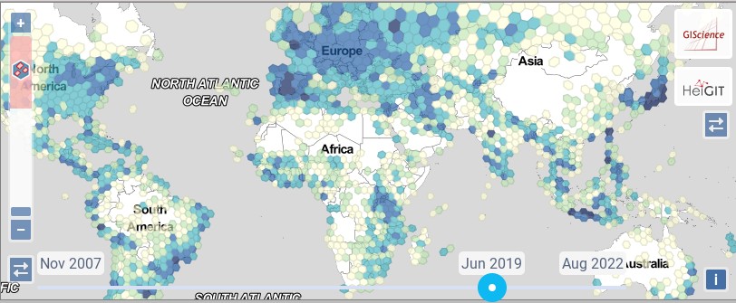
Интеграция Ohsome Quality Analyst в ohsomeHeX [1] | © HeiGIT | © Тайлы Stamen Design | Данные карты © OpenStreetMap contributors
О нас
- weeklyOSM теперь и на украинском!
Картографические акции
- Влодзимеж Бартчак сообщил
>
, что OpenStreetMap Poland и Педагогический университет Кракова организуют «Картографический полигон Пелешац», недельный учебный лагерь для студентов под руководством опытных редакторов OSM. Мы можем следить за ними по хэштегу #peljesac в правках, например, с помощью osmcha.
Картографирование
- Михаэль Райхерт сообщил, что в OSM Inspector добавлено отображение отношений
highway=*и неиспользуемых дорог. Также отображаются возможные ошибки в их тегировании. - Предложения, ждущие комментариев:
- объявить устаревшим
passenger_information_displayв пользуdepartures_board. settlement_type=crannogдля обозначения доисторических поселений, представляющих собой искусственные острова, построенные на озерах или морских заливах. Обычно встречаются в Ирландии, Шотландии и Уэльсе.privacy=*для обозначения степени уединения, которую обеспечивают удобства, например, душ или туалет.payment:coins|notes:denominations=*для обозначения номиналов принимаемых монет или купюр.amenity=training_centreдля унификации маркировки заведений, предоставляющих дополнительное или специальное обучение (но не включая университеты и общеобразовательные школы).amenity=pickup_pointдля обозначения пунктов самовывоза заказанных товаров, вместоshop=outpost.- заменить список рассылки Tagging на (новый) форум сообщества OSM, как предписанную площадку для получения комментариев к предложениям и голосований по ним.
- переместить голосование по предложениям из вики на форум сообщества OSM.
- объявить устаревшим
Сообщество
- Thunderforest, один из спонсоров проекта osm2pgsql, опубликовал интервью с Йохеном Топфом, одним из ведущих разработчиков osm2pgsql.
- Cartocité, французское консалтинговое агентство, специализирующееся на OpenStreetMap, проводит съемку улиц в коммуне Лонс-ле-Сонье. Собранные данные будут загружены в Mapillary для использования в OpenStreetMap.
- Во время проблем в работе OSMCha пользователь martien-176 напомнил о других альтернативах.
Фонд OpenStreetMap
- Операционная рабочая группа (OWG) OSMF выпустила отчет за август 2022 года.
События
- Записи докладов со State of the Map 2022 выложены на YouTube и media.ccc.de.
- Опубликованы материалы Академического трека на конференции State of the Map 2022.
- Комитет SotM Japan объявил, что SotM Japan 2022 пройдет 3 декабря в Какогаве, Хёго.
- Топи Тюканов, создатель интерактивной карты «Знаменитые люди» и организатор 30DayMapChallenge, в своем твиттере рассказал о нескольких альтернативных форматах предстоящей акции. Как всегда, 30DayMapChallenge будет проходить в течение ноября.
- Ежемесячная встреча OpenStreetMap Switzerland теперь будет проходить
>
в смешанном формате. Расписание можно узнать в вики
>
- Отделение OpenStreetMap US объявило о проведении онлайн-конференции MappingUSA, которая пройдет полностью в режиме онлайн 11 и 12 ноября. В этом году MappingUSA будет совместным мероприятием с WikiConference North America. Участие в конференции бесплатное. Прием заявок на участие открыт до 15 октября.
Карты
- Кристоф Хорманн рассказал в блоге о запланированном на сентябрь 2022 года окончании эксплуатации спутника Landsat 7 после 20 лет работы.
- Взгляните на эту 2×2 карту, которая показывает, как выглядел OSM в 2008, 2009, 2012 и 2022 годах.
Программы
- [1] Ризван Хан сообщает, что HeiGIT начал интегрировать часть функций Ohsome Quality Analyst в ohsomeHeX, инструмент для визуализации карт и развития данных в OSM.Одной из добавленных функций стал индикатор насыщенности данных. Например, если за последние несколько лет рост числа зданий в области остановился, то индикатор покажет, что данные достигли насыщения.
- Вышел Leaflet v1.9.0… и уже через день хотфикс 1.9.1.
- Tykayn создал
>
бота в Mastodon, который каждый день делится «OSM-тегом дня» из французской вики. За ботом можно следить по хэштегу #rtfw.
Программирование
- Аманда МакКэнн пишет в дневнике о своем инструменте, который находит заданные пары соседних POI. Вдохновлено обнаружением расположенных рядом банка и оружейного магазина, о которых мы сообщали в выпуске 634.
- Фонд Prototype Fund финансирует
>
проект анализа парковочных мест в OpenStreetMap. Его цель — дать подробную информацию о парковках в виде интерактивных карт и данных пригодных для экспорта. Ранее мы писали, что фонд также финансирует проект Йохена Топфа osm2pgsql.В проектную группу входят Алекс, Ларс и Тобиас из OSM Berlin. Чтобы поддержать заинтересованных в сборе данных о парковках, группа также работает над документацией и инструкциями для местных картографических акций.
А вы знаете …
- …что на новом форуме сообщества OSM можно отвечать на своем родном языке независимо от языка раздела? Всё благодаря переводчику Discourse.
- … о браузерном расширении OSM Smart Menu для переключения между сервисами, связанными с OpenStreetMap? Оно учитывает координаты и масштабирование на текущей странице, и помогает переключаться между различными картами и инструментами.
OSM в прессе
- Дельфин Сабатье взяла интервью у
►
Флориана Лайнеза об инициативах OpenStreetMap, касающихся конфликта между Украиной и Россией.Флориан известен участием во многих проектах, включая «ÇaResteOuvert»
, платформе, которую люди использовали во время локдауна, чтобы делиться часами работы магазинов через суффикс
:covid19, или менее серьёзном проекте «Panneau biche»
, который собирает информацию о дорожных знаках дикой природы.
Другие “гео” события
- Любите 3D карты, фантастические миры и визуализации? Откройте этот Twitter-тред и насладитесь!
- Компания HBO опубликовала карту вымышленного мира Вестероса из сериала «Игра престолов».
Предстоящие события
Примечание: Если вы хотите видеть своё мероприятие здесь, добавьте его в календарь. Данные оттуда автоматически появятся в еженедельнике. Не забудьте указать город и страну.
Над этим выпуском работали: 4004, Lejun, Strubbl, TheSwavu, derFred, richter_fn.