27/11/2018-03/12/2018
Reference point for mobile devices 1 | © Kanton Zürich, Baudirektion, Amt für Raumentwicklung
About us
- The Swahili version launched with great enthusiasm shortly after the SotM 2018 in Milan, unfortunately, had to be discontinued. Laura Mugeha will continue to inform the Swahili speaking community on her diary.
Mapping
- PoliMappers, the YouthMappers’ chapter at Politecnico di Milano (Italy), is organising the second edition of PoliMappers Adventures. During the month of December, you can complete a daily quest related to the world of OpenStreetMap. Quests range from mapping, humanitarian help, and many other subjects. Follow them on Twitter for more updates.
- CartoRoute (“MapRoad”) is a collaboration between Michelin and the OSM Ivory Coast association aiming to map the main road network across the country: road status, surface, speed limits, traffic signs, dining areas, hotels, and gas stations in the area surrounding the roads, etc. The pilot phase of the project has started in the commune of Plateau (Abidjan) where 11 local OSM contributors collected data during two days using OsmAnd, as related in this Twitter moment.
- The tag
cycleway:surfacehas already been used over 500 times but it was only now properly documented in the OSM Wiki. The tag allows specifying the surface of just the cycleway, for example for a cycleway on a road, where the surfaces differ. - The new Organised Editing Guidelines have been approved by the board during the previous OSMF board meeting on November 15th. The guidelines, which were drafted by the Data Working Group, aim to improve the documentation, transparency and the practices of organised mapping initiatives.
- The lack of maintenance of the electoral boundaries in Germany led to the proposal
 (automatic translation) to delete the data. The proposal received a lot of support but also some opposition.
 - The voting for mapping ‘tramtrack on highway’ failed. However, the originator Jukka Nikulainen is preparing a new proposal based on the feedback he received during the proposal process.
 (automatic
 Community
- Can Ünen (OSM unen), university lecturer in Istanbul, Turkey, is the new Mapper of the Month. As usual, OSM Belgium published a background interview with the winner.
- South Korean mapper GPIOIPG made a survey as to whether OSM public transport station names should have the suffix
-역(i.e. station). Usually, the official names are without the suffix. Apparently, the suffix is widely used by people and even some signs show the suffix, but ‘station’ isn’t attached after station names in other countries. In a blog post at his user diary, GPIOIPG writes about the result of his survey, that he has advertised at the forum and the mailing list, and provides some more background information. - Nakaner has loaded all the e-mails from all public mailing lists on lists.openstreetmap.org into a database. Two entries (1, 2) in his user blog contain the number of messages per year and per mailing list and the list of the most active authors.
- SunCobalt notes that shortly before the current and the past election the number of OSMF members increases strongly and visualises this by a graphic. Honi soit, qui mal y pense.
OpenStreetMap Foundation
- The official manifestos and candidates responses for this year’s OSMF board election have now been published. Christoph Hormann has written a summary and Paul Norman has written an evaluation guide. There are discussions in the Forum as well as on osmf-talk mailing list.
- The Membership Working Group (MWG) reports about its recent activity. The MWG is currently busy with the new membership fee waiver program and has to deal with countries that have no suitable money transfer options for paying the membership fee. As with weeklyOSM, and other OSMF working groups, the MWG is looking for volunteers.
- Mikel Maron, OSMF board member, announced the launch of Welcome Mat. The website Welcome Mat was started to help external organisations to understand OSM’s difficult structure, to explain how OSM works, and how and where to engage.
Events
- FOSS4G Italy announced (automatic translation) a call for papers or workshops proposals for the third Italian FOSS4G 2019, which will be held in Padua from 20th to 24th February. Proposals are due by the 13th December.
Humanitarian OSM
- OpenGovHub hosted a mapathon on December, 4th with the HOT Staff at the OpenGov Hub in Washington, DC.
- HOT provides an update on their Microgrants 2018 program that was launched in April 2018. Eight communities received microgrants in order to improve OSM and help to minimise the impact of disasters.
Maps
- OpenStreetBrowser now has a new category under “Leisure, Sport and Shopping”. According to skunk’s blog post, the new category “Swimming and Bathing” includes all kind of swimming and bathing facilities and saunas.
switch2OSM
- Qwant, a search site, based in France, is now using OSM vectorial data and a lot of OSM inside.
Programming
- Heidelberg University’s GIScience Research Group introduced API Playground, which allows you to explore OpenRouteService API services, parameters, and responses.
- Matthias made a prototype of an external voice controller for JOSM. The tool speech2JOSM is available on GitHub.
Releases
- A new stable version of JOSM has been released. Version 18.11 saves the height of each panel on the right when JOSM is closed, it comes with a dedicated button for
Download as new layer, instead of a tick box and improves a lot of other features. The most notable change is probably the fix of the glitched GPS traces caused by the OSM website API change.
Did you know …
- The MapOSMatic instance at osm-baustelle.de recently exceeded 40,000 rendered maps. The website further enhanced its functionality with user interface improvements and hyperlink support in multipage PDF outputs.
- Stefan Keller, Computer Science Professor at the University of Applied Sciences of Rapperswil, has created a Fog Map. The map shows how to find your way to the sun on grey, foggy November days. The website Bluewin.ch provides (automatic translation) some background information and tests if the map works. Unfortunately, the map only covers Switzerland.
- …. the service kinderkiez.net? The service, that is available in English and German, lets you create a children’s play mat with a map based on OSM.
- … the long list of links to places where you can find a suitable tag if you can’t find one in your editor’s presets?
Other “geo” things
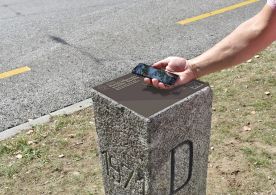
- In Switzerland, an old international boundary post has been relocated to the grounds of the Swiss National Museum in Zurich. It now provides the first reference point for mobile devices (automatic translation) via QR codes or a website (OSM-Link).
- The iXpoint company won (automatic translation) the Baden-Württemberg Challenge of the European Satellite Navigation Competition (ESNC) 2018 with its OSM based pedestrian routing.
- Gaël Musquet, founder and former spokesman for OpenStreetMap France (French local chapter of the OSM Foundation), has been awarded (automatic translation) the French National Order of Merit, along with one of the VLC developers. He sees it as a recognition for the whole community and the leading French figures in open-source.
- Medium.com explains how to get ADS-B position data from airplanes onto an OSM based map using Python and the Cartopy library.
Upcoming Events
| Where | What | When | Country |
|---|---|---|---|
| Alice | PoliMappers Adventures 2018: One mapping quest each day | 2018-12-01-2018-12-31 |  |
| Niamey | OSM and GIS training camp at CNF | 2018-12-03-2018-12-07 |  |
| Tångstad | Foundation board elections voting opens | 2018-12-08 | – |
| Ouagadougou | Mapathon Independance Day at La Ruche | 2018-12-10 |  |
| Rennes | Réunion mensuelle | 2018-12-10 |  |
| Lyon | Rencontre mensuelle pour tous | 2018-12-11 | |
| Zurich | Jubilee Stammtisch Zurich with Fondue | 2018-12-11 |  |
| Salzburg | Maptime Salzburg | 2018-12-12 |  |
| Mannheim | Mannheimer Mapathons – now in Ludwigshafen! | 2018-12-12 |  |
| Helsinki | Missing Maps Mapathon at Finnish Red Cross HQ – Dec 2018 | 2018-12-13 |  |
| Munich | Münchner Stammtisch | 2018-12-13 | |
| Berlin | 126. Berlin-Brandenburg Stammtisch | 2018-12-14 | |
| online via IRC | Foundation Annual General Meeting | 2018-12-15 | |
| Cologne Bonn Airport | Bonner Stammtisch | 2018-12-18 | |
| Lüneburg | Lüneburger Mappertreffen | 2018-12-18 | |
| Nottingham | Pub Meetup | 2018-12-18 |  |
| Reutti | Stammtisch Ulmer Alb | 2018-12-18 | |
| Rennes | Recensement des panneaux publicitaires | 2018-12-23 | |
| Leipzig | OpenStreetMap assembly | 2018-12-27-2018-12-30 | |
| Heidelberg | State of the Map 2019 (international conference) | 2019-09-21-2019-09-23 | |
Note: If you like to see your event here, please put it into the calendar. Only data which is there, will appear in weeklyOSM. Please check your event in our public calendar preview and correct it, where appropriate.
This weeklyOSM was produced by PierZen, Polyglot, Rogehm, SK53, SunCobalt, TheSwavu, derFred, jinalfoflia.