04/05/2021-10/05/2021
Museums CH-DE-AT-IT-FR [1] | © Leaflet | © OpenMapTiles, © OpenStreetMap contributors | Powered by Wikimedia CH and Synapta
About us
- Our Korean contributor and translator, Donga Hwang (OSM contributor LuxuryCoop), will be doing their military service with the Air Force. As a result our Korean issue will have a hiatus of at least two months.
Mapping campaigns
- OpenStreetMap U.S. is organising the ‘Mapping USA Virtual Event’ to be held on 20 to 22 May.
- On 10 May, due to a lowering of the COVID-19 alert level in the Republic of Ireland, travel outside your county become possible. OpenStreetMap Ireland CLG directors are so pleased with this news that they are going to organise a very special mapping campaign, like none before.
Mapping
- Javier Sánchez Portero wrote
 > about the labelling of threshing floors (
man_made=threshing_floor), referring to the discussions so far and giving his personal view. He also referred > to the super-valuable Spanish-language web page (‘Características que generan dudas en España’) which facilitates the proper interpretation of the British English OSM terms. Be careful: The automatic translation to your language could be even more confusing. 
- As part of Geonight, on Friday 9 April Kathmandu Living Labs (KLL) organised a comprehensive on-the-ground mapping of tourism-related businesses in the Thamel quarter of Kathmandu. In two hours the 31 volunteers recorded 751 businesses, which have now been added to OSM. KLL members also interviewed business owners about the impact of the COVID-19 pandemic on loss of trade.
- The proposal for post_office=* (formerly
post_partner=*) started two weeks ago. For any stragglers, voting has been extended by one week until 19 May. - Voting is open for the following proposal until 21 May:
landuse=educationfor grounds with multiple educational amenities (e.g. kindergarten, school) instead the amenity* tag doubled on ground and a node.
- Voting has ended for the following proposals:
emergency=lifeguardwas approved with 17 votes for, 4 votes against, and 2 abstentions.historic=tombwas approved with 12 votes for, 1 vote against, and 6 abstentions.boundary=forestrywas not successful with 73 votes for, 74 votes against, and 3 abstentions.was:place_of_worship=mass_rockwas approved with 11 votes for, 1 vote against, and 1 abstention.amenity=clubhousewas not successful with 13 votes for, 14 votes against, and 2 abstentions.
- Because of illegal Eifel routes on Komoot, the district of Düren and Komoot met > in court (article unfortunately behind a paywall). The result of the negotiations is that joint solutions are being sought, Komoot is training national park administrations in OSM mapping and the district environmental office is now possibly contributing to OSM itself in order to improve the map and adapt the bicycle routing accordingly.
 >
> 
 >
> Community
- Want to know how Geomob find such a broad spectrum for their interviews and podcasts? A short twitter thread highlights the sources they find most useful.
Local chapter news
- OpenStreetMap Polska celebrated > their 10th anniversary on 30 April. The post also gives a brief history of OSM-PL over the past decade, culminating in its recent acceptance as an official chapter of OSMF.
 >
> Events
- On Monday 17 May at 16:00 GMT OpenStreetMap Ghana, CartONG France, HuMap Trier University, Leclara, MAnnheimer MAPAthons, and DisasterMappers Heidelberg University will hold an international mapathon with the theme ‘Lets Map with Her’. OSM Ghana will offer a short introduction to QGIS in parallel with breakout rooms for regular mapping using the HOT Tasking Manager. Register to join this event at this link.
- The call for posters for State of the Map (SotM) 2021 has been announced. The deadline for submissions is Sunday 27 June.
Education
- Igor Eliezer presented > , with some examples from OSM and JOSM, the situation and updates to the mapping of the municipality of Laranjal Paulista.
 >
> Humanitarian OSM
- Kontur has added wildfire alerts into Disaster Ninja notifications in Humanitarian OSM Slack #disaster-alerts channel (login required). GDACS data is enriched with affected population estimates by Kontur. Within one click you can start analysing the event on the Disaster Ninja dashboard.
Maps
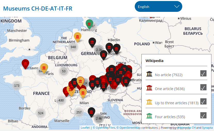
- [1] Wikimedia CH presented its map of museums in Switzerland, Germany, Austria, Italy and France, differentiated by colour according to the number of Wikipedia articles.
- ‘Map on Demand’ is a free service of the Federal German Agency for Cartography and Geodesy for generating downloadable, printable maps in various formats. Help for this is available here (-pdf).
Software
- The JOSM developers have merged a patch to provide support for using background layers of vector tiles (in the Mapbox format).
- User K_Sakanoshita announced an update to ‘Town walk map maker‘ that added many icons. They also published some example maps .
 an update to ‘
Programming
- Nominatim’s developers explained the importance of normalising various kinds of text strings, such as place names, name elements and queries, when processing OSM data for geocoding. They are in the process of re-factoring the current implementation to allow both ease of maintenance and more localised usage of the normalisation rules.
Releases
- Organic Maps, a fork of maps.me, has been released on Google Play, and on Apple TestFlight.
Other “geo” things
- Ida Hoffart, of Septima, discussed (dk) > the design of user interfaces for web maps used as a background for other data.
- According to the BBC, a Belgian farmer moved a stone marking the boundary between France and Belgium by a few metres because it was in the way of his tractor. The mayors of the two municipalities concerned are rather amused, but the farmer could be prosecuted if he does not replace the stone in its original location.
- VentureBeat provided a top-level view of geographical databases, but they managed to add a superfluous ‘s’ to OpenStreetMap.
- Deidre Mask has written a book titled The Address Book which explores hidden histories behind street names.
Upcoming Events
| Where | What | Online | When | Country |
|---|---|---|---|---|
| Mannheim | International Mapathon (Ghana, France, Germany) | 2021-05-17 |  | |
| Gárdony | OSM Duma: interactive discussion (topic to be determined, online) | 2021-05-17 |  | |
| Lyon | Rencontre mensuelle (virtuelle) Lyon | ✓ | 2021-05-18 |  |
| 139. Treffen des OSM-Stammtisches Bonn | 2021-05-18 | |||
| Berlin | OSM-Verkehrswende #23 (Online) | 2021-05-18 | | |
| Lüneburg | Lüneburger Mappertreffen (online) | 2021-05-18 | | |
| Decatur County | Mapping USA | ✓ | 2021-05-20 – 2021-05-22 |  |
| Missing Maps DRK Online Mapathon | 2021-05-20 | |||
| gmina Krośniewice | Virtual meeting of the Polish OSM Association | 2021-05-21 |  | |
| Amsterdam | Virtual Meet OpenStreetMap NL | ✓ | 2021-05-22 |  |
| Bremen | Bremer Mappertreffen (Online) | 2021-05-24 | | |
| Derby | East Midlands OSM Pub Meet-up : Derby | 2021-05-25 |  | |
| Gárdony | Monthly Hungarian OSM conference (topics to be determined) | 2021-05-25 | | |
| Ville de Bruxelles – Stad Brussel | Virtual OpenStreetMap Belgium meeting | ✓ | 2021-05-25 |  |
| Düsseldorf | Düsseldorfer OSM-Treffen (online) | 2021-05-26 | | |
| okres Žilina | Missing Maps mapathon Slovakia online #3 | 2021-05-27 |  | |
| [Online] OpenStreetMap Foundation board of Directors – public meeting | 2021-05-28 | |||
| gmina Krośniewice | Virtual meeting of the Polish OSM Association | 2021-05-28 | | |
| London | Missing Maps London Mapathon | 2021-06-01 | | |
| Landau an der Isar | Virtuelles Niederbayern-Treffen | ✓ | 2021-06-01 | |
| Stuttgart | Stuttgarter Stammtisch (Online) | 2021-06-01 | | |
| Dresden | Dresdner OSM-Stammtisch | ✓ | 2021-06-03 | |
| Berlin | 156. Berlin-Brandenburg OpenStreetMap Stammtisch (Online) | 2021-06-04 | | |
| Rapperswil-Jona | OSM-Sonntag (FOSSGIS-Konferenz 2021) | 2021-06-06 |  | |
| Rapperswil-Jona | FOSSGIS-Konferenz 2021 (Online) | ✓ | 2021-06-06 – 2021-06-09 | |
Note:
If you like to see your event here, please put it into the OSM calendar. Only data which is there, will appear in weeklyOSM.
This weeklyOSM was produced by Lejun, Nordpfeil, SK53, TheSwavu, YoViajo, derFred.
Den Paywall-Artikel über Komoot kann man hier (halbwegs) lesen: https://epaper.zeitungsverlag-aachen.de/2.0/api/az-d/20210510/12/big
You can (somewhat) read the paywalled article about Komoot here: https://epaper.zeitungsverlag-aachen.de/2.0/api/az-d/20210510/12/big (in German)