15/08/2024-21/08/2024
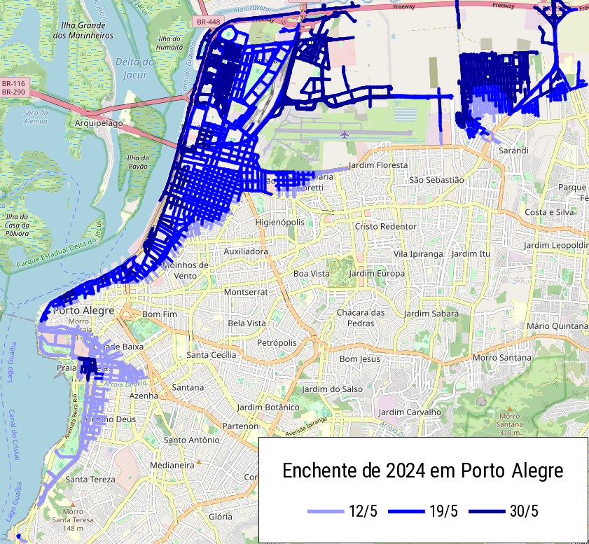
Mapping Rio Grande do Sul’s flood of 2024 [1] | © ftrebien | Map data © OpenStreetMap contributors
Mapping
- [1] ftrebien described
 ►
► his efforts to map the roads blocked, destroyed, or under construction due to the 2024 floods in the state of Rio Grande do Sul, Brazil. He detailed the challenges in updating OSM with precise and accurate information amid unreliable commercial maps, fragmented official data, and questionable information, as well as highlighting the impact of the disaster on infrastructure and local communities. His work is not finished yet!
 - Peter showed a road sign with a speed limit and a notice about an autonomous vehicle operating between 8 am and 9 pm. He questioned its meaning and asked
 if there are any mapping suggestions for it on OpenStreetMap.
 - Comments are requested on:
- The proposal to deprecate the tag
cycleway=sharedin favour of more precise tags. - The proposal to replace the tag
denomination=mormonwithdenomination=latter_day_saint. - The proposal to introduce
waterway=flowlinefor mapping the flow path through a water body where it ceases to be recognisable as a stream or river. - The proposal to establish default access restrictions for roads in Sweden, aligning with local traffic laws and simplifying the tagging of access rights.
- The proposal to deprecate the tag
Community
- Ian Dees shared his experiment of using the OpenAI API to suggest OpenStreetMap tags derived from a provided image. He has developed a tool that generates tag recommendations for images, with the aim of simplifying the mapping process for OSM contributors. The tool is currently in a testing phase, with a prototype available for feedback, and Dees is exploring ways to refine the output without directly adding data to OSM.
- Perkumpulan OpenStreetMap Indonesia and the OSM iD community have completed and released the OSM iD Tagging Guidelines that standardise the tagging of objects in Indonesia from the Wiki Map Features and OpenStreetMap TagInfo. The guidelines are also available in Bahasa Indonesia for OSM users in Indonesia.
- The German Federal Agency for Cartography and Geodesy has launched a call for tenderers to develop a quality assurance system to assess the quality of OpenStreetMap data.
- kaccin discussed a location that is restricted
 ► to residents, highlighting that OpenStreetMap lacks detailed information about the surrounding area. He reflected on the challenges of mapping such places due to limited access and data availability.
 - The Verkehrsgemeinschaft Mittelthüringen (a public transport body operating in central Thüringen, Germany) is seeking ► a consultant or instructor to help with the correct mapping of public transport routes and stops, and the use of JOSM.
OpenStreetMap Foundation
- The next OSMF Board meeting will be held on Thursday, 29 August at 13:30 UTC with very interesting topics, including:
- Report of the treasurer
- Membership and CiviCRM working group
- LCCWG update: 31-day OSM challenge for October
- LCCWG update: Local SotM support discussions
- Taking action against data consumers who permanently plagiarise OSM data and do not use OSMF tile servers
- DSGVO updates
- Presentation – OSM Colombia and/or Latin America
Access to the meeting will be available through the video room.
Events
- IVIDES.org is continuing to commemorate
 ► 20 years of OpenStreetMap, including a mapathon in one of the cities affected this year by the floods in the State of Rio Grande do Sul, Brazil. In her diary ► Raquel thanked TomTom for sponsoring two vouchers, which will be raffled off on the last day of the event, Friday 30 August. You can still take part and celebrate!
 - OpenStreetMap was founded in 2004, almost exactly 20 years ago. Falk Zscheile’s lecture looked back at the development of the OSM project during this time and dares to take a look into the future. Various aspects, such as data quality, the community, the law, and curiosities are examined among other things.
- State of the Map Latam is the annual conference for all map creators and OpenStreetMap users in Latin America. This year the event will be free of charge, in person, and based in Brazil. The submission of talks and papers is open until Saturday 31 August.
OSM research
- In a research paper presented at the 62nd Annual Meeting of the Association for Computational Linguistics, Paz-Argaman and others (Bar-Ilan University and Google Research) described how they used OSM data to generate navigation instructions in natural language, as people might give to each other (‘Meet me in the garden’. ‘Head northwest …’). Their aim is to improve AI systems by trying to determine the target coordinates after providing a map, starting point, and navigation instructions. Generating the navigation instructions requires identifying prominent landmarks relevant to a route, so they also described how they used OSM tags to identify landmarks.
Maps
- Christoph Hormann discussed the extension of high-resolution 10-metre satellite imagery coverage in West Asia (the Middle East not including Egypt), focusing on the ‘Musaicum’ project. This project aims to improve the accuracy and detail of geospatial data in the region, with specific challenges related to desert and mountainous terrain. He also touched on the technical aspects of image processing and the potential applications of these improved data in mapping and environmental studies.
OSM in action
- Daniel Capilla has been working on improving ► the mapping of tombs and funerary architecture in the City of Málaga, Spain. This city has two historic cemeteries, both declared Places of Cultural Interest; the English Cemetery ► and the Cementerio Histórico de San Miguel ►. He is reproducing the plan of the San Miguel cemetery, using uMap, with the geolocation of the graves of historical personalities and funerary monuments.
- ‘Welcome To My Garden‘ is a web map maintained by a not-for-profit network of citizens offering free camping spots in their gardens to travellers. The software is available on GitHub.
 ►
►Software
- Opening Pifomap (an initiative from OpenStreetMap France to create an address node database) on a phone browser was always a strange idea. Until now, it was strongly discouraged unless you wanted to lose your eyes and your nerves. But things are now very different; Pifomap has a usable mobile version.
- The MAPS.ME team described how they implemented bus navigation in the app and the problems that had to be solved for this purpose. Also MAPS.ME has deployed a global validator for bus routes.
 (an initiative from OpenStreetMap France to create an address node database) on a phone browser was always a strange idea. Until now, it was strongly discouraged unless you wanted to lose your eyes and your nerves. But things are now very different; Pifomap has a
  how they implemented bus navigation in the app and the problems that had to be solved for this purpose. Also MAPS.ME has deployed a global
 Programming
- Jochen Topf discussed his experience with an ‘out of memory’ error that occurred while processing large datasets with the Osmium tool, explaining the technical challenges and his approach to debugging and resolving the problem, which included analysing memory usage and optimising code to handle large OpenStreetMap data more efficiently.
Releases
- The August 2024 release of Organic Maps was delayed due to the unexpected removal of the app from the Google Play Store.
Did you know …
- … that the OSMF provides an application form for individuals wishing to become Active Contributor members of the OpenStreetMap Foundation, specifically for contributors who qualify through non-mapping activities? The form collects personal information, outlines the eligibility criteria, and explains the submission process for applicants.
- … what Bangle.js is? It’s a watch with open firmware and there is an app available to view OpenStreetMap maps.
- … that FixMyStreet based websites use OSM-based maps? FixMyStreet has an interactive map to allow users to mark the exact locations of problems such as potholes or illegal rubbish dumping, which are then reported to the relevant authorities. FixMyStreet is OSS and available on GitHub.
- … that Volker Schatz published ‘The hacker’s guide to OpenStreetMap‘ more than ten years ago? This guide provided tips about customising the setup of an OSM-based map.
- … WikiShootMe? A tool that allows users to locate places on a map where photos are needed for Wikimedia projects, highlighting areas that lack images and encouraging contributions to improve coverage on Wikipedia, Wikidata, and Wikimedia Commons.
OSM in the media
- OpenStreetMap is celebrating its 20th anniversary as an open collaborative mapping platform. How has the project developed over time? Can OSM compete with commercial providers? What does the open source philosophy mean for the future of digital cartography? You can learn more about this in a live stream episode of the #heiseshow.
Other “geo” things
- Wheelmap.org (an OSM-based app for accessibility) is looking ► for two full stack developers (Node.js, TypeScript, Kubernetes) to be based in Berlin, Germany.
- Red Blob Games discussed the challenges and strategies for effectively placing labels on maps, emphasising the balance between readability and avoiding overlap. They explored some of the different algorithms and techniques used to optimise label placement, such as the trade-offs between fixed position and dynamic labels, and how these methods are applied in interactive maps.
Upcoming Events
| Where | What | Online | When | Country |
|---|---|---|---|---|
| San Jose | South Bay 20th Birthday Social with Open Source San José | 2024-08-23 |  | |
| Rio de Janeiro | [on-line]  20 anos de OSM #3 – Oficina do IVIDES.org no III GSEA-UFRJ (Brasil) 20 anos de OSM #3 – Oficina do IVIDES.org no III GSEA-UFRJ (Brasil) | 2024-08-23 |  | |
| Dover | Mapping the Disc Golf Course at Bellamy Park [ | Where | What | Online |
| ——————— | ————————————————————————————————————————————————————————— | —— | ———————– | ———————————————————————– |
| San Jose | South Bay 20th Birthday Social with Open Source San José | 2024-08-23 | | |
| Rio de Janeiro | [on-line] 20 anos de OSM #3 – Oficina do IVIDES.org no III GSEA-UFRJ (Brasil) | 2024-08-23 | | |
| Dover | Mapping the Disc Golf Course at Bellamy Park | 2024-08-24 – 2024-08-25 | | |
| Diliman | OpenStreetMap 20th Fun Run + Picnic (OSM Philippines community) | 2024-08-24 |  | |
| Karol Bagh Tehsil | 11th OSM Delhi Mapping Party | 2024-08-25 |  | |
| Stadtgebiet Bremen | Bremer Mappertreffen | 2024-08-26 |  | |
| Missing Maps Mapathon Potsdam | 2024-08-28 | |||
| Zürich | Missing Maps Zürich Mapathon | 2024-08-28 |  | |
| Düsseldorf | Düsseldorfer OpenStreetMap-Treffen (online) | 2024-08-28 | | |
| [Online] OpenStreetMap Foundation board of Directors – public videomeeting | 2024-08-29 | |||
| Campos dos Goytacazes | [on-line] 20 anos de OSM #4 – Oficina do IVIDES.org para a UFF-Campos (Brasil) – Lançamento do YouthMappers UFF Campos! | 2024-08-30 | | |
| OSMF Engineering Working Group meeting | 2024-08-30 | |||
| Stadtgebiet Bremen |   [Bremen] Mobile Mappingparty mit Kuchen [Bremen] Mobile Mappingparty mit Kuchen | 2024-09-01 – 2024-10-01 | | |
| Rostock | Vortrag: 20 Jahre OpenStreetMap – Ein Blick auf die Community und ihre Arbeit | 2024-09-02 | | |
| MapRoulette Community Meeting | 2024-09-03 | |||
| iD Community Chat | 2024-09-03 | |||
| Christiansburg | OSM NRV Map Night | 2024-09-04 | | |
| San Jose | South Bay Map Night | ✓ | 2024-09-04 | |
| Missing Maps London: (Online) Mapathon [eng] | 2024-09-03 | |||
| Brno | Kvartální OSM pivo | 2024-09-04 |  | |
| Stuttgart | Stuttgarter OpenStreetMap-Treffen | 2024-09-04 | | |
| Nairobi | State of the Map 2024 | 2024-09-06 – 2024-09-08 |  | |
| Bengaluru | IndiaFOSS 4.0 | 2024-09-06 – 2024-09-07 | | |
| 中正區 | OpenStreetMap x Wikidata Taipei #68 | 2024-09-09 |  | |
| Diliman | OpenStreetMap 20th Fun Run + Picnic (OSM Philippines community) | 2024-08-24 | | |
| Karol Bagh Tehsil | 11th OSM Delhi Mapping Party | 2024-08-25 | | |
| Stadtgebiet Bremen | Bremer Mappertreffen | 2024-08-26 | | |
| Missing Maps Mapathon Potsdam | 2024-08-28 | |||
| Zürich | Missing Maps Zürich Mapathon | 2024-08-28 | | |
| Düsseldorf | Düsseldorfer OpenStreetMap-Treffen (online) | 2024-08-28 | | |
| [Online] OpenStreetMap Foundation board of Directors – public videomeeting | 2024-08-29 | |||
| Campos dos Goytacazes | [on-line] 20 anos de OSM #4 – Oficina do IVIDES.org para a UFF-Campos (Brasil) – Lançamento do YouthMappers UFF Campos! | 2024-08-30 | | |
| OSMF Engineering Working Group meeting | 2024-08-30 | |||
| Stadtgebiet Bremen | [Bremen] Mobile Mappingparty mit Kuchen | 2024-09-01 – 2024-10-01 | | |
| Rostock | Vortrag: 20 Jahre OpenStreetMap – Ein Blick auf die Community und ihre Arbeit | 2024-09-02 | | |
| MapRoulette Community Meeting | 2024-09-03 | |||
| iD Community Chat | 2024-09-03 | |||
| Christiansburg | OSM NRV Map Night | 2024-09-04 | | |
| San Jose | South Bay Map Night | ✓ | 2024-09-04 | |
| Missing Maps London: (Online) Mapathon [eng] | 2024-09-03 | |||
| Brno | Kvartální OSM pivo | 2024-09-04 | | |
| Stuttgart | Stuttgarter OpenStreetMap-Treffen | 2024-09-04 | | |
| Nairobi | State of the Map 2024 | 2024-09-06 – 2024-09-08 | | |
| Bengaluru | IndiaFOSS 4.0 | 2024-09-06 – 2024-09-07 | | |
| 中正區 | OpenStreetMap x Wikidata Taipei #68 | 2024-09-09 | |
Note:
If you like to see your event here, please put it into the OSM calendar. Only data which is there, will appear in weeklyOSM.
This weeklyOSM was produced by Elizabete, MatthiasMatthias, Michael Montani, PierZen, Raquel Dezidério Souto, SeverinGeo, Strubbl, TheSwavu, TrickyFoxy, barefootstache, derFred, mcliquid, miurahr, rtnf.
We welcome link suggestions for the next issue via this form and look forward to your contributions.
The events are listed twice. E.g., OpenStreetMap x Wikidata Taipei #68 .
For the “Upcoming Events” section…
Would it be more readable to flip the columns into this order?
– Date
– Country
– Where
– What
Currently, your eyes have to jump between dates/flags, then city names.
(And many cities, like “Rostok”, you may not even be familiar with… but paired with the German flag, you can then quickly see if it applies to your location or not.)
We have put your good idea into our backlog. Thank you very much.