10.08.2021-16.08.2021

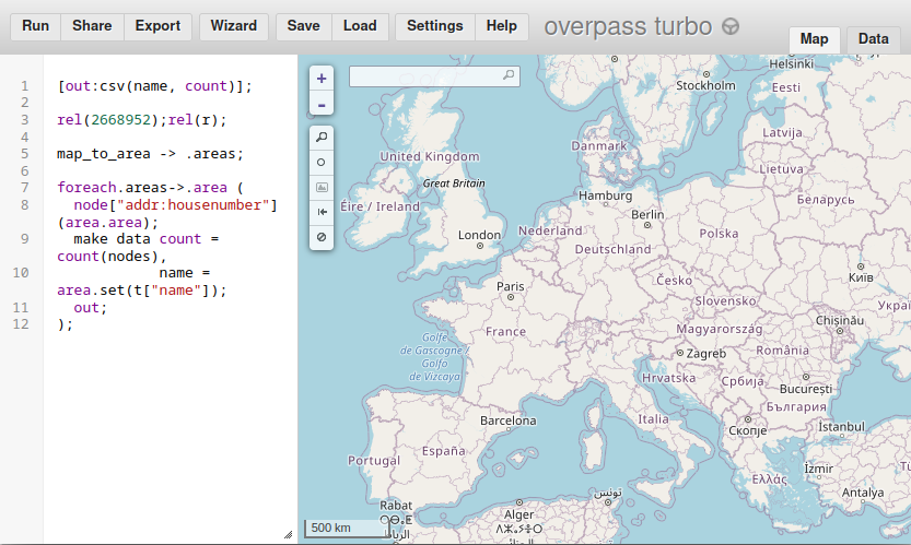
count addr:housenumber nodes across all EU member states, broken down by country, will run in 30 seconds on an Overpass development branch [1] | map data © OpenStreetMap contributors
Haritalama
- Birden fazla ulaşım modu için tasarlanmış dinlence rotalarının nasıl etiketleneceği üzerine fazla uzun süren konu Kevin Kenny’nin etiketlemenin platonik bir ideallikte olması için çabalamanın gerekli olmadığını önermesine neden oldu.
- oh8mxl kullanıcısı, “bölgenizdeki bisiklet haritalama hatalarını ve fixme etiketlerini nasıl kontrol edersiniz” konulu bir blog yazısı yazdı.
- Aşağıdaki önerilere ilişkin görüş talep edilmiştir:
- Dinlence rota bağlantıları için yeni bir rol ‘transferi’. Wiki sayfası yok ama mail listesi başlığına buradan ulaşabilirsiniz.
cadet=militaryyerel askeri öğrenci biriminin buluşma noktasının haritasını çıkarmak için önerilen etiket,club=cadetyerel genç öğrenci grubunun buluşma noktasının haritasını çıkarmak için önerilen etiket.
- Aşağıdaki önerge için oylama sürüyor:
man_made=video_wallbüyük dijital ekranları eşlemek için (23 Ağustos Pazartesi’ye kadar).
- Aşağıdaki teklifler için oylama sona erdi:
cultivated=no/semi/fullynatural=scruba alt etiket eklemek için 25 lehte, 18 aleyhte ve 2 çekimser oyla başarısız oldu.barrier=cycle_barrierbisiklet bariyerleri için etiketlemeyi uzatmak için 31 evet, 2 aleyhte ve 0 çekimser oyla kabul edildi.
Topluluk
- OSMF Yönetim Kurulu üyesi Amanda, Temmuz ayı için yönetim kurulu faaliyet raporuyla şimdi güncel.
- OSM forumunun yerini almak için Discourse ‘ın kullanılmasıyla ilgili tartışmalar bir süredir devam ediyor. Fransız topluluğu, forumlarını phpBB’den Discourse’a ve ayrıca mevcut tüm gönderileri eski sistemden taşıdı
>
. Alman forumunda, https://forum.openstreetmap.org‘dan geçiş yapılırken, eski gönderilerle (örneğin: Hollanda > 60.000, Rusya > 260.000 ve Almanya> 300.000) nasıl başa çıkılacağı sorusu gündeme geliyor
>
.
- Kullanıcı marriotomo, HOT Tasking Manager’da barındırılan projelere ayrıntılı bir göz atarak, kaçının başlatıldığı, kaçının bitirildiği ve ne kadar süredir aktif olduklarına ilişkin istatistikler topladı.
İçe Aktarımlar
- MSF’den gelen bir e-postada, CBS görevlisi Roxana Nazarie, saha ekipleri tarafından toplanan ve onaylanan hassas olmayan verileri OSM ile paylaşmanın planlı bir yolunu açıkladı. İçerik, hızlı bir yanıt için verilerin paylaşılması gerektiğinde içe aktarma işleminin çok uzun soluklu olmasıdır. Çoğu yanıt, önerilen yöntemin zaten bir içe aktarmadır ve bir dizi başka yaklaşım da önerilmiştir.
- Attila Kun ve Brian Sperlongano, Batı Virginia Eyalet Ormanlarının içeri aktarılmasını teklif ediyor.
OpenStreetMap Vakfı
- Yerel Bölümler ve Topluluklar Çalışma Grubu Denetleme Alt Komitesi tarafından önerilen taslak Görgü Kuralları, 8 Eylül Çarşamba gününe kadar görüşlere açık. Komite, Talk ve osmf-talk mail listelerine başvuru yapacaklardır. Ancak yazarlar, bunları OSMF tarafından işletilen tüm platformlara (forum, wiki ve ulusal posta listeleri) de uygulamanızı tavsiye etmektedir. Yorumlar tartışma sayfasında yazılabilir ve gözden geçirilebilir.
Haritalar
- Neukölln’ün sokak manzarası haritasında caddelerin, kaldırımların ve cadde kenarındaki park yerlerinin OSM verileriyle nasıl temsil edilebileceğini ilgili haritadan görebilirsiniz. Tobias Jordans bu blog yazısında
>
hangi verilerin görselleştirildiğini ve verilerin nasıl elde edildiğini açıkladı.
- Dirk Brockmann, COVID-19 durumuna küresel bir bakış atmak isteyen kişileri ilgili görseli incelemeye davet etti.
- Ashley Pinner ve Harry Wood, Twitter’da çeşitli OSM haritalarının demiryolu platformlarını nasıl gösterdikleri hakkında konuştu.
Özgür Veri
- 2018’den bu yana Birleşik Krallık hükümeti, Coğrafi Mekansal Komisyonu veya en azından onların yüklenicilerini, ağırlıklı olarak yönetim danışmanlıklarını cömertçe finanse ediyor. Bu nedenle, güvenilir kuruluşlardan yakın zamanda yayınlanan
coğrafi mekansal verilerin listesinin çok fazla boşluk içermesi biraz şaşırtıcı. Peter Wells, raporun yalnızca OSM’den hiç bahsetmediğini, aynı zamanda ülkenin çoğu için yetkili bir adres kaynağının bulunmadığını düşündüğünü fark etti.
Lisanslar
- สุทธิสาร ปานสัสดี, OSM bağlamında çok çeşitli lisanslama seçeneklerini yansıtıyor >
. Çalışmaları için geri bildirim istiyor.
Yazılım
- Yash Srivastava, Google Summer of Code Projesi hakkında ekran görüntüleri ile gösterilen son bir güncelleme yaptı. Nominatim (OpenStreetMap verileriyle Açık kaynaklı coğrafi kodlama)
Geri Bildirim Raporlayıcı, kullanıcıların OpenStreetMap arama (Nominatim) hatalarını göndermesine olanak tanyor. Bu geribildirimler daha sonra geliştiriciler tarafından test durumları olarak eklenebilir. - [1] Kullanıcı mmd, ülkelere göre ayrılmış olarak tüm AB üyesi ülkelerde
addr:housenumberdüğümlerini saymak için bir sorgunun bir Overpass geliştirme sürümünde 30 saniye içinde nasıl çalışacağını gösterdi. Aynı sorgu mevcut üretim sürümlerinde çalışmayacaktır. - OrganicMaps (OSM tabanlı bir mobil uygulama), sunucular için ödeme yapılmasına ve fon geliştirilmesine yardımcı olmak için bir bağış kampanyası başlattı.
Programlama
- Kullanıcı mahdi1234, Çek topluluk kanalı #osmcz:matrix.org’daki taginfo’dan istatistikleri bildirmek için bir Matrix sohbet robotu oluşturma hakkında kısa bir makale yayınladı.
Biliyor muydunuz?…
- İsviçreli haritacı Eduard Imhof‘u biliyor muydunuz? Haftanın tarihi haritasıyla ilgili öğemiz. Gölgeli kabartma haritaları yaratmada öncülük etti (geçen hafta öne çıkardığımız yönüyle) ve etkili bir ders kitabının yazarıydı. Ayrıca, yetenekli teknik asistanlarla beraber, bazıları Bern’deki İsviçre Alp Müzesi‘nde görülebilen bir dizi büyük ölçekli kabartma modelleri yarattı.
- Walter Nordmann’ın yazılım izleme listesiyle OSM yazılım dünyasındaki gelişmeleri takip edebileceğinizi biliyor muydunuz?
- Pascal’ın Unmapped Places adlı web sitesini biliyor muydunuz? Bu araç, 700 metre yakınına kadar yol olmayan
placeetiketlerini göstererek, haritalanmamış bir yerleşimin varlığına işaret eder.
Gelecek etkinlikler
Not: Eğer etkinliğinizin burada görünmesini istiyorsanız lütfen takvime ekleyin. Sadece takvimdeki veriler Haftalık OSM’de görülecektir. Lütfen etkinliğin gerçekleşeceği şehir ve ülkeyi de takvimde belirtmeyi unutmayın.
HaftalıkOSM bu hafta size Burce_eren, Denizdogaisik, Nakaner, SK53, TheSwavu, derFred, erenozdemir, ilginozemir, strangeece tarafından ulaştırıldı.