20.02.2025-26.02.2025

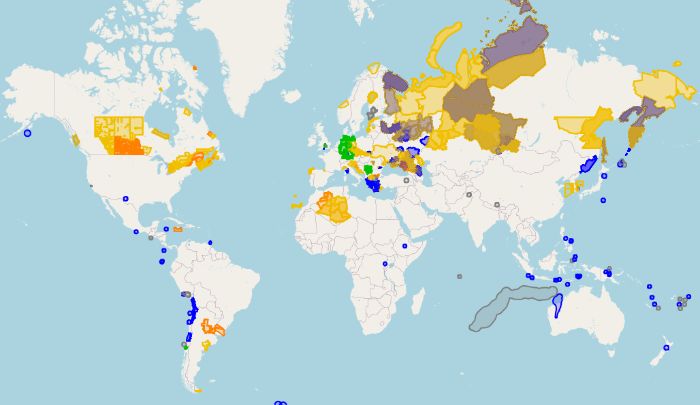
[1] OSM Hack Weekend’den acil durum ve meteorolojil uyarı harita görünümü | Map data © OpenStreetMap Contributors.
Topluluk
- ENSTP’nin OSM Kulübü geri döndü ve siz de davetlisiniz. Programda eğitim, konferanslar, projeler ve daha birçok sürpriz var. Bu etkinlik, Ecole Nationale Supérieure des Travaux Publics
topluluğunun Kamerun’daki faaliyetlerinin başlangıcına işaret etmektedir.
- Jean-Christophe Becquet, Fransa’nın Isère kentinde düzenlenen açık kaynak ve özgür yazılım etkinliği AlpOSS‘ta “Bölgenizdeki Katkıları Teşvik Etmek” başlıklı bir sunum yaptı
. OpenStreetMap ekosisteminin çeşitli bölge ve temalardaki deneyimlerinden yola çıkan bu sunum, dijital bir müşterek etrafındaki katılımı teşvik etme yönteminin ana hatlarını çiziyor.
Etkinlikler
- [1] Almanya’nın Karlsruhe kentinde Geofabrik tarafından düzenlenen ve OSM’yi de kapsayan KDE Itinerary, Transitous ve acil durum veya hava durumu uyarısı konularında tartışılan ve üzerinde çalışılan OSM Hack Weekend‘in sonuçlarını öğrenebilirsiniz
>
.
- 15 Mart 2025’te çevrimiçi olarak gerçekleşecek olan 5. yıllık OpenStreetMap Yerel Temsilcilikler ve Topluluklar Kongresi’ne hâlâ kayıt olabilirsiniz
>
.
Eğitim
- Raymond Lay, QGIS için yeni yayınlanan ve kullanıcıların bir dizi görselleştirme tekniği kullanarak platformdaki birden fazla haritayı karşılaştırmasına olanak tanıyan QMapCompare eklentisini tanıttı
>
.
OSM Araştırmaları
- Wiki Movimento Brasil’den Peschanski, Jurno ve Hilsenbeck Filho, UFMG (Brezilya) tarafından desteklenen Texto Livre (Açık Metin) adlı bilimsel dergide, dijital genişletme projelerinde açık çözümlere ilişkin bazı başarılı vaka çalışmalarını tartışan, açık erişimli bir makale yayınladı
>
. Makalede, 2024 yılında Rio Grande do Sul’da yaşanan felaket sırasında oluşturulan, trafiğe kapalı ya da tahrip olmuş yol ve köprüleri gösteren uMap haritasından bahsedildi. Sorunlu köprü ve otoyol verileri Fernando Trebien (OSM RS) tarafından OpenStreetMap’e aktarılmış ve uMap haritası da Raquel Dezidério Souto (IVIDES.org ve YouthMappers UFRJ) tarafından oluşturulmuştu.
Haritalar
- hflan Meksika ile ABD arasındaki su kütlesinin adının OpenStreetmap Körfezi olmasını öneriyor
>
. Aynı MapQuest aracını kullanarak, Bir Hayalim Var Körfezi‘nin nerede olduğunu da bulabilirsiniz.
OSM İş Başında
- OpenStreetMap vahşi doğada: Birkaç hafta önce Fransa’nın Doubs ilçesi, LinkedIn’de yeni çalışanlarından biri olan Adrien Zhang hakkında bir paylaşım yaptı ve bazı kullanıcılar masasının üzerinde OSM logosunu gözden kaçırmadı. İlçe aynı zamanda trafik bilgilerini paylaşmak için InfoRoute’un bir örneğini kullanıyor
(bu da masaüstü ekranında görülebiliyor) ve temel katman olarak OSM’ye güveniyor.
Özgür Veri
- Daha önce de belirttiğimiz gibi, OpenLandMap OpenGeoHub tarafından paylaşılmakta, çok sayıda tematik katman göstermekte ve OpenStreetMap’i mevcut temel katmanlardan biri olarak kullanmaktadır. Proje açık verilerle çalışıyor ve Geoserver, React, plumber R ve OpenLayers gibi açık kaynaklı yazılımlara dayanıyor. Yeni olan şey, OpenLandMap artık Bing hava görüntülerini de içeriyor.
- Kailash Nadh ve Madhav Pai, “Mobilitede Açık Veri” başlıklı son konuşmalarında OpenStreetMap’in dijital bir kamu malı ve dijital kamu altyapısının temel bileşeni olarak önemini vurguladı
. Oturum, 21 Şubat 2025 tarihinde, daha güvenli ve sürdürülebilir bir ulaşım geleceğini şekillendirmek için uzmanları, karar mercilerini ve vatandaşları bir araya getiren, Bengaluru’nun kentsel hareketliliğinin üç günlük derinlemesine araştırması olan Namma Raste’nin ikinci gününde gerçekleşti.
Yazılım
- RollTideRoll_asdfjkll adlı kullanıcı, Bing görüntülerine JOSM’de erişilemediğini bildirerek
>
ilgili bir sorun biletinin yeniden açılmasına neden oldu. Mikel Maron, tüm OSM editörlerinin şu anda iD tarafından kullanılan anahtarı kullanıp kullanamayacağını sormak için Microsoft ile koordinasyonun devam ettiğini doğruladı. Bu yazı yazıldığı sırada Microsoft henüz yanıt vermemiştir.
- David Karlaš, OpenStreetMap web sitesine yararlı düğmeler ekleyen betiğini güncelledi
>
. Güncellenen betik artık OSMCha ve level0 editörüne doğrudan bağlantılar içeriyor ve OpenStreetMap web sitesinin yakın zamanda güncellenen versiyonuyla çalışıyor.
- Lucas Jellema, QGIS’te CartoDB ve OpenStreetMap kullanımı hakkında bir kılavuz yayınladı
>
.
Biliyor muydunuz?…
- Avrupa verileri için resmi portal olan data.europa.eu‘da binden fazla OSM veri seti olduğunu?…
Diğer “yersel” şeyler
- Reddit kullanıcısı Throwboi321, kebap kalitesinin tren istasyonlarına yaklaştıkça düştüğü hipotezini araştırmak için bir CBS analizi gerçekleştirdi
>
. Navigasyon ağları ve tren istasyonu konumları için OSM verilerini, lezzet referansı olarak kullandığı Google Haritalar incelemeleriyle birleştirerek, bu iddianın geçerliliğini değerlendirmeyi amaçlıyordu.
- Diego Alonso, QGIS 3.42 (Münster) sürüm adayının öne çıkan özelliklerini paylaştı.
>
.
- Burghardt, Demidova ve Keim, Springer Nature tarafından 2024 yılında yayınlanan ve Technische Universität Dresden‘in (Almanya) Institut für Kartographie birimi tarafından yürütülen VGIscience programı bünyesinde yayınlanan makaleleri içeren gönüllü coğrafi bilgi (VGI) hakkında açık erişimli bir kitabın editörlüğünü yapmıştır.
Gelecek Etkinlikler
Not: Eğer etkinliğinizin burada görünmesini istiyorsanız lütfen takvime ekleyin. Sadece takvimdeki veriler Haftalık OSM’de görülecektir. Lütfen etkinliğin gerçekleşeceği şehir ve ülkeyi de takvimde belirtmeyi unutmayın.
HaftalıkOSM bu hafta size Raquel Dezidério Souto, Setenay, TheSwavu, Can tarafından ulaştırıldı.