08/09/2020-14/09/2020
I want to work with OSM data! – Which tool do I need? 1 | © HeiGIT gGmbH
Mapping
- Michał Brzozowski asked, on OSM-talk, for some examples of good paid mapping. He has received many responses from mappers sharing their experiences and opinions.
- Crowd2Map Tanzania organised and hosted training sessions for YouthMappers chapters at the Institute of Rural Development Planning Dodoma (IRDP) and the University of Dodoma (UDOM) on open geospatial data and open source geospatial software.
- ‘Ça reste ouvert’, the French original ‘Staying open’, closes
 > on 30 September 2020, with the satisfaction of the work done by the team and the certainty of having made a contribution to the big picture. Its creators will then launch the development of the OpenStreetMap community’s ‘project of the month’: a new ‘energy catalyst’ tool for more collaborative adventures!
 - François Lacombe published a very detailed proposal, with photos and examples, to create three new tags to better describe pumps used for liquids.
Please feel free to comment. - François Lacombe is also proposing the new tag
man_made=utility_poleand asks for comments. His proposal aims to review and completeman_made=utility_polewith existingutility=*for poles intended for other activities than power transmission and distribution.
 >
> 
Community
- Allan Mustard, aka apm-wa, published a diary entry about his new camera setup for Mapillary imagery and the recent decisions of the OSMF Board about funding the development of OSM editors (namely iD, Potlatch and StreetComplete) and the hire of a full-time system reliability engineer.
- Branko Kokanovic has created a Mapnik-based tile server where names are internationalised. He has retrieved the names from Wikidata and Wikipedia. The project is available on GitLab.
- Florian Lainez is proposing > an OSM-Fr Association newsletter, which would include news from the association itself such as communications or board decisions, general OSM updates and project of the month > related news.
Imports
- Sous-surveillance.net was created 7 years ago and has stored in their database the location of around 20,000 cameras, mostly located in France and Belgium. OSM currently has the location of around 80,000 cameras over the entire world. After a successful test import in March 2020, for the city of Brussels, in September 2020 authorisation has been granted to import the full dataset into OSM.
OpenStreetMap Foundation
- The OSMF announced that their 14th Annual General Meeting will be held online on 12 December. More details will be available soon on the dedicated wiki page.
Events
- On Sunday, 4 October 2020, 25 Swiss castles invite you to the 5th National Castles Day. The Wikimedia CH association and Swiss OpenStreetMap (SOSM) will complement the event with a Swiss ‘Burgentag’. They ask for the mapping of castle ruin sites and initiated a photo challenge to upload photos of castles missing from Wikimedia Commons.
Humanitarian OSM
- Disaster Map Foundation, a Jakarta-based non-government organisation, has launched ‘MapaKalamidad.ph‘, a web-based, flood reporting platform to help disaster authorities gather life-saving information during calamities in the Philippines. The project was done in partnership with the Office of Civil Defense (OCD), National Disaster Risk Reduction and Management Council, Pacific Disaster Center, and Humanitarian OpenStreetMap Team.
- HOT’s 2020 Summit has moved online. It will be held virtually across multiple time zones on 4 December, in conjunction with the Understanding Risk conference. The theme is ’10 Years of HOT: The Past, Present and Future of Humanitarian Mapping’. Proposals are currently being accepted for sessions.
- Eugene Chong has written a blog post entitled ‘How Can OpenStreetMap be Used to Track UN Sustainable Development Goals?’.
- Flip Science reporter Mikael Angelo Francisco gave a first-hand account of joining in on a Missing Maps mapathon to map villages in Nigeria.
- Mikel Maron has written an article entitled ‘Typhoon season in Japan: Crisis Mapping and OpenStreetMap’.
- Thomson Reuters Foundation News covered the work of the humanitarian mapping community supporting COVID-19 responses in communities around the world.
Education
- Stratofortress explained, in his instructable, how to create custom-stylised maps using OpenStreetMap.
Maps
- Have you ever thought ‘Gee, I wonder what would happen if you took #OpenStreetMap data for North America, and coloured the image based on the distance to the nearest building?’ If yes, Rory McCann can show you the results.
- Omri Wallach presented a 3D map which shows the highest population density centres of the world.
- Have you ever thought about the distribution of street suffixes such as streets, boulevards, avenues, and other roads in a city? Lansingography gave us some examples from Lansing, Michigan, USA.
Open Data
- Have you ever wondered what GTFS is and how to use it to complete OpenStreetMap? Noémie Lehuby, from Jungle Bus, has published > a long blog post explaining the format, the steps to follow and the tools that can be used to map public transport routes and stops in OpenStreetMap from a GTFS open dataset.
Software
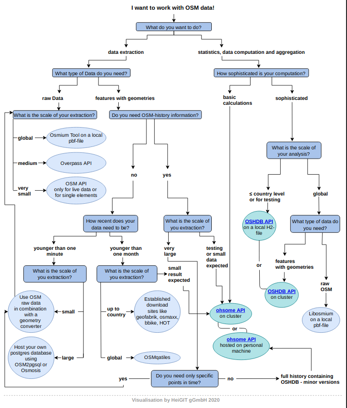
- [1] Marcel Reinmuth, from HeiGIT in Heidelberg, drew attention, in a blog post, to a decision tree that helps you choose which of the various tools from ohsome suits your needs. The flowchart can be downloaded as a PDF.
- JOSM is now also available in Farsi (a language spoken in Iran and elsewhere).
- This year Nominatim celebrates its 11th birthday. On 11 November 2009, the OpenStreetMap (OSM) homepage used Nominatim as its main search engine for the first time. Since then OSM has grown enormously and with it the need for a geocoder based on OSM data. The OSM Nominatim servers alone now serve more than 30 million queries per day. Read more about the present and future for Nominatim.
Programming
- Paul Norman explained, on the Dev discussion list, that the upgrade of Ironbelly, the primary site planet server, to Ubuntu 20.04 revealed a bug in the software that generates the weekly planet dump. He also described the various actions taken to fix the problem.
- Stefa called on all JOSM plugin authors to follow them in transforming their icons to SVG (or to reuse JOSM core icons if suitable).
Releases
- Fabian Kowatsch reported on changes and new functions in the ohsome API on the GIScience News Blog.
- iD released patch update 2.18.5 with changes from 12 contributors, seven of whom are new!
Did you know …
- … the interactive Geo Open Accessibility Tool (GOAT)? This tool allows dynamic analysis of walking and cycling accessibility to different destinations (e.g. supermarkets, schools).
- … that every user gets a blog on OpenStreetMap? Go ahead and write your first blog post!
- … Pascal Neis has updates on Trends and Changesets?
- … the bike travel wiki? Here you will find > references to maps and route planners, but also to everything else that is of interest to cyclists.
 >
> OSM in the media
- GeoSpatial World showed which interesting discoveries can be made during walks through your own or a foreign city. OsmAnd supports the navigation, if necessary, with maps downloadable for offline use.
- Researchers at the Technion (Israel Insititute of Technology) have developed an innovative mapping system for blind pedestrians (we reported earlier). Their study examined the possibility of using OpenStreetMap to map spatial data relevant to blind pedestrians while calculating optimised walking routes.
- The director of Ramblers Scotland (Ramblers is the largest hillwalking organisation in GB, ~100 years old with ~120k+ members) says OSM ‘has the most complete public map of Scotland’s paths that is currently available’.
Other “geo” things
- Grant Slater reports that there is, finally, a free RTK / NTRIP Broadcaster in London.
- The United Nations has decided to establish a new UN Global Geodetic Centre of Excellence (GGCE) in the city of Bonn, Germany.
- The Karlsruhe-based software company Disy Informationssysteme GmbH presented > the new version of their data analytics, reporting and GIS platform ‘Cadenza’. The extension of the analytics functionalities with the provision of an integrated routing function and the POI search are two of the essential innovations.
- Matt Burgess presented the best privacy-friendly alternatives to Google Maps, which is arguably the easiest mapping service to use, but that doesn’t mean it’s the most secure.
- The earth observation company 4 Earth Intelligence (4EI) has published information packages that provide an overview of countries in six layers (demography, land cover, points of interest, major events, transport and wealth index). The Country Intelligence Data Suite, derived from satellite imagery and other resources such as the World Bank, OpenStreetMap, census data and historical archives, was created to support economic analysis, policy-making and reporting on the SMART Sustainable Development Goals (SDGs). The information is provided as a mixture of point, line and polygon features and is suitable for use in desktop mapping software or geographic information systems (GIS).
Upcoming Events
| Where | What | When | Country |
|---|---|---|---|
| Kabul / Online | Why OSM and how to Contribute into it on Software Freedom Day 2020 | 2020-09-18 |  |
| Nottingham | Nottingham pub meetup | 2020-09-22 |  |
| Bratislava | Missing Maps Mapathon Bratislava #9 | 2020-09-24 |  |
| Munich | TUM – Mapping Party | 2020-09-24 |  |
| Alice | HOT Working Groups 101 Community Webinar | 2020-09-25 | |
| Düsseldorf | Düsseldorfer OSM-Stammtisch | 2020-09-25 | |
| Helsinki | State of the Map Suomi 2020 | 2020-09-26 |  |
| Salt Lake City / Virtual | OpenStreetMap Utah Map Night | 2020-09-29 |  |
| Zurich | Missing Maps Mapathon Zürich | 2020-09-30 |  |
| Ulm + virtuell | Covid-19-Mapathon | 2020-10-01 | |
| San José | Civic Hack & Map Night | 2020-10-01 | |
| Taipei | OSM x Wikidata #21 | 2020-10-05 |  |
| London | Missing Maps London Mapathon | 2020-10-06 | |
| Stuttgart | Stuttgarter Stammtisch | 2020-10-07 | |
| Berlin | 148. Berlin-Brandenburg Stammtisch | 2020-10-09 | |
| Alice | 2020 Pista ng Mapa | 2020-11-13-2020-11-27 |  |
| Alice | FOSS4G SotM Oceania 2020 | 2020-11-20 |  |
Note: If you like to see your event here, please put it into the calendar. Only data which is there, will appear in weeklyOSM. Please check your event in our public calendar preview and correct it, where appropriate.
This weeklyOSM was produced by AnisKoutsi, Anne Ghisla, Climate_Ben, MatthiasMatthias, MichaelFS, Nordpfeil, NunoMASAzevedo, PierZen, Polyglot, Rogehm, TheSwavu, derFred, richter_fn
Where is “Alice”? 🙂
Seems like a bug for all online events.