01/17/2017-01/23/2017
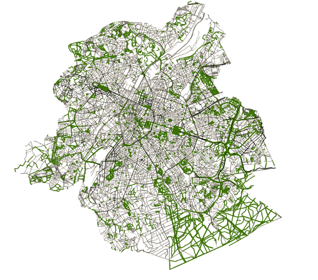
Brussels from 2006 to 2016 1 | © Joost Schouppe & OpenStreetMap contributors CC-BY-SA 2.0
Mapping
Chethan Gowda from Mapbox writes about this awesome OSMIC JOSM style plugin which enables icons on all POIs when editing OpenStreetMap.
A user is asking in the OSM Forum if there is an alternative to Bing for Malaysia as large areas are not covered yet.
User Wille from Brasilia, made available the GPS tracks collected by the Brazilian Environmental Protection Agency. To use this data in ImproveOSM, Martijn van Exel tweaked the algorithm for recognizing missing roads. ImproveOSM now contains many unpaved roads in Brazil. ImproveOSM, works with iD editor and there is also a JOSM plugin of the same.
A tweet from Brundritt informs that Bing Maps have been updating its imagery. This process should be completed in a few months according to the tweet.
On talk-GB, Andrew Hain reports that a mapper added names to polygons
landuse=residentialandlanduse=commercialin south west London (UK). This mapper did not respond to the changeset comments posted by Hain indicating that the names should be in the description and not the polygons themselves.Joost Schouppe asks which tagging scheme for dog toilettes should he publish as a proposal for voting.
On the Tagging mailing list, there is a discussion about OSM tags for public transport cards data, which are gradually replacing transport tickets, according to user Warin.
On the Tagging mailing list, Martijn van Exel is asking about
destination:streettags which were noticed by Telenav mapping team on (mostly)motorway_linkoff-ramps in Canada. It’s an undocumented sub-tag of the destination tag. Van Exel is asking about how it is being used and if there is some sort of consensus that is documented somewhere else other than the OSM wiki.Joost Schouppe raises the discussion about
shop=fuelwhich was already mentioned here. The issue concerns shops that sell fuel but are not fuel stations. Joost proposes identifying such products.Mapbox updated the basemap imagery in Washington, DC with 2015 aerial imagery at 3 inch (7.5 cm) resolution. Great for mapping (make mapping great again) and counting people as well when you need alternative facts.
Community
Escada interviews Steve All from California (USA), for his Mapper of the Month series. The interview is published on the new website of the Belgian OSM community.
According to Pascal Neis, while the number of OSM mappers is increasing around the world, it is decreasing in Germany.
Are 25.000 mappers enough for Germany? It’s enough for the urban areas but in the rural ones there is still much to do, a weeklyOSM editor says.
Imports
Michael Spreng asks on the imports mailing list about the import of addresses in the Canton of Bern (GEBADR list). There has been no feedback concerning to it. The import was refined and the bulk import is starting, which is expected to take some time. Building layouts are going to be improved when possible.
Humanitarian OSM
Pascal Neis comments on a Russell Deffner’s tweet about the validation process of Missing Maps. This process apparently produces a lot of OSM changes.
Logistics Cluster updates its access constraints map in South Sudan every Friday. This should be of special interest to humanitarian deliveries in the area.
Maps
Paul Norman suggests a simple extension to CartoCSS which would decrease the size of our main page’s style by about one third.
Molly Lloyd from Mapbox teamed up with some organizers from the Women’s March to create a map where you can find all the events of Woman’s March in different cities and countries.
Take back the tech! uses technology to end violence against women and encourages activism against gender-based violence. Using an OSM-based map, people can report cases of violence against women from all over the world.
Some of the issues faced by people creating symbols for map styles aren’t always appreciated.
Stephan Bösch-Plepelits showcases on the Dev mailing list, the PTMap, a public transport map rendering based on Overpass API, which renders route relations according to the ‘new’ PTv2 scheme.
Joost Schouppe shows in his diary how road mapping (tag
highway=*) evolved in Brussels.
switch2OSM
GeoBolivia migrates to georchestra 15.12.
Open Data
The international Open Data Hackathon will take place on March 4, 2017. The map was broken at our editorial deadline.
Weather data which is produced by the German Weather Service (DWD) could be freely available in the future, according to an article
 of the Spiegel Online. (automatic translation)
 of the Spiegel Online. (automatic
 Licences
Due to copyright issues with Mapbox, the project OSM2VectorTiles was discontinued. The authors have created a successor, the OpenMapTiles, with their own vector tile scheme, and free from legal problems.
Software
Lukas Martinelli has released a first stable version of Maputnik the OSS Map Designer.
Programming
For the Google Summer of Code 2017, project proposals are being collected in the Wiki.
Geofabrik reports in a blog post how they recently improved referential integrity in their extracts. With a marginal impact on file size while cutting down processing time, this was made possible by switching to the latest osmium version.
Releases
Mapbox releases ios-v3.4.0 of their iOS SDK, which brings in changes with improved packaging and documentation, more control over styles and data, and so much more. They also released macos-v0.3.0 SDK which corresponds to version 3.4.0 of the Mapbox iOS SDK.
| Software | Version | Release date | Comment |
|---|---|---|---|
| Mapillary Android * | 3.21 | 2017-01-15 | Minor fixes. |
| Naviki Android;* | 3.53 | 2017-01-15 | Display driving direction, some bug fixes. |
| Mapillary iOS * | 4.6.1 | 2017-01-18 | added optional push messages, upgraded to Mapillary-JS 3.0, fixed viewer bug (hopefully). |
| Osmium tool | 1.5.1 | 2017-01-19 | Two changes and three bug fixes. |
| OSRM | 5.5.4 | 2017-01-19 | Five bug fixes. |
| Leafletjs | 1.0.3 | 2017-01-23 | Twelve bug fixes, two API changes, two improvements. |
Provided by the OSM Software Watchlist. Sorry, still offline 🙁
(*) unfree software. See: freesoftware.
OSM in the media
Mapanica, the OSM community in Nicaragua, proposes a new project to help improve the frequency data of public transport, in order to create a system that allows people to better plan their trips in the city of Managua.
German TV GRIP_RTL2 used stamen’s great looking #watercolor OpenStreetMap for Romania in their yesterday’s episode (via pascal_n). No attribution was mentioned.
Other “geo” things
This is how buildings look when OSM enthusiasts are rebuilding their house.
Geospatial World wrote about DigitalGlobe’s AComp: "When a satellite takes an image, the light reflecting from the ground is impacted by the atmosphere and can affect the visual aesthetics of the image. That’s where DigitalGlobe’s Atmospheric Compensation (AComp) steps in."
Carlos Felipe Castillo informed: "The new private beta from Blueshift has arrived!" A fun and easy tool to create dynamic maps.
Euro space agency’s Galileo satellites have been stricken by mystery clock failures.
Eric Gundersen shows a satellite image of Barack Obama’s presidential inauguration in 2009 by GeoEye, now DigitalGlobe.
Open Stats from India notes that Uber’s OpenData Platform is not really Open Data. They call it #openwashing.
Upcoming Events
| Where | What | When | Country |
|---|---|---|---|
| Zaragoza | Mapeado Colaborativo | 01/27/2017 |  |
| Dresden | Stammtisch | 02/02/2017 |  |
| Lyon | Stand OSM Salon Primevère | 02/03/2017-02/05/2017 |  |
| Brussels | FOSDEM 2017 | 02/04/2017-02/05/2017 |  |
| Rostock | Rostocker Treffen | 02/07/2017 | |
| Genoa | OSMit2017 | 02/08/2017-02/11/2017 |  |
| Berlin | 104. Berlin-Brandenburg Stammtisch | 02/10/2017 | |
| Rennes | Atelier de découverte | 02/12/2017 | |
| Cardiff | OpenDataCamp UK | 02/25/2017-02/26/2017 |  |
| Passau | FOSSGIS 2017 | 03/22/2017-03/25/2017 | |
| Avignon | State of the Map France 2017 | 06/02/2017-06/04/2017 | |
| Aizu-wakamatsu Shi | State of the Map 2017 | 08/18/2017-08/20/2017 |  |
| Buenos Aires | FOSS4G+SOTM Argentina 2017 | 10/23/2017-10/28/2017 |  |
Note: If you like to see your event here, please put it into the calendar. Only data which is there, will appear in weeklyOSM. Please check your event in our public calendar preview and correct it, where appropriate.
This weeklyOSM was produced by Hakuch, Peda, Polyglot, Rogehm, SeleneYang, Spec80, YoViajo, derFred, jinalfoflia, keithonearth, vsandre, wambacher, widedangel.