11.04.2023-17.04.2023

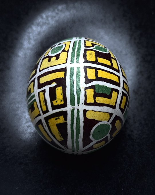
Писанка від пристрастної картографки [1] © Margarita Hohun
Термінові новини
- Наступне засідання правління Фундації заплановане на четвер 27 квітня, 13:00 UTC в кімнаті osmvideo (див. попередній порядок денний).
- Вебсайт OpenStreetMap.org та повʼязані з ним сервіси будуть недоступні протягом короткого періоду часу між 00:00 CEST (GMT/UTC+2) та 06:00 CEST у середу 26 квітня 2023 року.
Мапінг
- Розпочато обговорення пропозиції щодо нового теґу
kerb:approach_aid=*. - Класифікацію доріг Луїзіани було схвалено 2-ма голосами «за» та з одним коментарем.
- CactiStaccingCrane розробив
►
чотириступеневу техніку мапінгу будівель, яка допомагає йому додавати будівлі на мапу в густонаселених міських районах, яку він називає «Ханойською вежею».
- Cartofy описує
►
труднощі з інструкцією з класифікації доріг в OSM для Індії. Він просить спільноту про допомогу, щоб «ми всі мали краще класифіковані дороги».
- SK53 зазначає
►
, що всюди потрібно працювати над покращенням інформації про обмеження швидкості на
highway=primary.
Спільнота
- Асоціація за свободу програмного забезпечення Тайваню взяла інтервʼю
►
в учасника спільноти OpenStreetMap Тайваню Supaplex. Він розповів про місцеву тайванську спільноту та власні спостереження стосовно нещодавно створеної Overture Map Foundation.
- У своєму блозі KAWAMALA публікує необхідні передумови для успішного проведення мапатону.
Фундація OpenStreetMap
- Саймон Пул в своїх твітах розповідає про цікаві відкриття в структурі компаній, повʼязаних з Linux Foundation.
Новини місцевих осередків
- Спільнота OSM землі Мекленбург-Передня Померанія відмовилася
►
від свого акаунта у Твіттері. Обговорювався
►
перехід на Mastodon, але врешті-решт цю пропозицію було відкинуто.
Події
- HeiGIT проведе
►
мапатон з мапінгу вічної мерзлоти в рамках проєкту UndercoverEisAgents 8 травня о 18:00 в приміщенні Mathematikon, INF 205 (IWR), Гейдельберг.
Мапи
- SomeoneElse опублікував повну версію всього коду map.atownsend.org.uk після багатьох оновлень. Наявні релізи чотирьох репозиторіїв — коду Lua, стилю мапи, який визначає вигляд мапи, легенди мапи та вебсайту для самої мапи.
- Overture Maps Foundation робить тестовий випуск спільно створеного набору картографічних даних, які можуть бути ресурсом для застосунків що працюють з геоданими.
Програмування
- qeef пише
►
про покращення, які він впровадив у вебклієнт damn. Зʼявився новий клієнт для маперів-початківців і нова сторінка перевірки якості даних.
А чи знаєте ви …
- … 3D-вид кантону Юра у Швейцарії?
- … що на топографічних мапах ізолінії використовуються для показу точок з однаковими значеннями. Ізолінії зазвичай використовуються для показу висоти. Вони також можуть представляти інші значення, такі як розподіл населення або магнетизм. Ось список поширених (і не тільки) типів ізоліній
►
які використовуються на мапах. Префікс «ізо-» означає «однаковий».
Інші “гео” події
- Писанка картографки в якої ностальжі за Подолом | © Margarita Hohun
- pyQGIS опублікував мапу з “Paschpunkte” у Німеччині. Джо Вігетрітт відвідав і сфотографував точки з однаковими частинами координат 48°48’48” 12°12’12” і 49°49’49” 09°09’09”.
- “Це справді так. Лавочки, які місто Майнц встановило на березі Рейну в районі Лаубенхайм, стоять спиною до річки, обличчям до автостоянки.” Повідомляє Klaus Euteneuer
- В інтерактивній статті The Economist простежив національну історію картографії Геодезичної служби (Ordnance Survey) у Великій Британії.
- Picterra інтегрувала Facebook’s Segment Anything Model (SAM) у свій картографічний застосунок, який дозволяє користувачам вибирати обʼєкти на аерофотознімку за допомогою “чарівної палички”.
- HeiGIT спільно з групою GEORISKS в Німецькому аерокосмічному центрі (DLR-DFD-GEO) пропонує магістерську роботу в контексті машинного навчання для опису інвентаризації будівель, повʼязаної з моделями ризиків природних небезпек. Метою дипломної роботи є опис інвентаризації будівель на основі поєднання повсюдно поширених багатоспектральних супутникових знімків та векторних даних (контурів будівель OSM).
Майбутні події
Якщо ви бажаєте бачити свою подію тут, додайте її до календаря OSM. До Тижневика WeeklyOSM потрапляють лише наявні в ньому дані.
Цей Тижневик OSM був створений Gontsa, MatthiasMatthias, SK53, andygol, darkonus, derFred.
Ми вітаємо ваші пропозиції посилань для наступного випуску через цю форму, та з нетерпінням чекаємо на вашу участь.