25.04.2023-01.05.2023

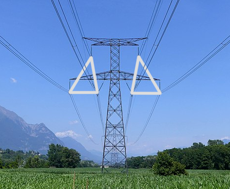
Ілюстрація розташування високовольтних ліній [1] | © CC-BY-SA-4.0 François Lacombe Florian Pépellin
Мапінг
- [1] Пропозиція щодо розміщення ліній електропередач зараз вимагає коментарів (RFC). Вона має на меті описати, як дроти ліній розташовані на опорах або точках шляху. Вони можуть бути розташовані горизонтально, вертикально або навіть у дельтоподібній формі.
- Пропозиція
parking_space=collectionочікує на ваші коментарі та запитання. Теґ призначається для опису спеціального паркувального місця де здійснюється посадка/висадка пасажирів. - Пропозиція
kerb:approach_aid=yes/noвідкрита для голосування до 15 травня 2023 року. - Пітер Елдерсон у своєму блозі розповідає про мапінг перехресть з круговим рухом, на яких організовано спіральне спрямовування трафіку, за допомогою JOSM. Турбо-кругові перехрестя дозволяють водіям вибирати напрямок руху перед вʼїздом, якого потім дотримуються на всьому перехресті.
- SK53 досліджує, чи використовуються теґи
leisure=pitchзsport=tennisдля тенісних кортів, як таких. Він зробив запит, який витягує теґи, геометрію та площу кожного поля у квадратних метрах, щоб перевірити це. Виявилося що відповідь негативна. Лише близько чверті тенісних кортів є одним обʼєктом, принаймні стільки ж обʼєктів мають площу двох полів, і ще стільки ж — більш ніж два корти. Незначна частка обʼєктів має теґи, що вказують на кількість кортів на кожній ділянці. - Duitama Mapping Stars, колумбійські школярі віком 13—16 років, складають мапу сталого транспорту для свого рідного міста та за його межами, в таких містах як Богота, Зітакуаро, Оуруро та Найробі.
Мапінг акції
- AE35 звітує про свою роботу
►
щодо проєкту MapRoulette Cemetery Challenge, який розпочався 26 березня 2023 року.Завдання полягає в тому, щоб нанести на мапу всі пішохідні доріжки та сходинки на 2440 данських кладовищах. Станом на 2 травня 50 % завдання вже виконано. 19 волонтерів додали близько 17 000 нових пішохідних доріжок/сходинок, а також нанесли на мапу 511 флагштоків. Мета — завершити проєкт до Різдва.
Спільнота
- Андрес Гомес Казанова продовжує
►
писати у своєму щоденнику про вебсайти, якими легко користуватися з мобільних пристроїв для покращення даних OSM, продовжуючи свій перший огляд мобільних застосунків (дивись попередній випуск).
- ivanbranco публікує в блозі
►
хороший список своїх улюблених інструментів/сайтів/додатків, повʼязаних з OSM, з коротким описом. В коментарях watmildon додає ще три цікаві інструменти.
Події
- Марія Пілар Перл Матео опублікувала
►
в «Геральдо» велику статтю про картографічну діяльність у Сарагосі, яку варто прочитати.Марія Пілар розповідає про мапатони в Малаві, Нігерії та Танзанії і пояснює, чому ці заходи необхідні. Спонсорами заходу виступили «Лікарі без кордонів», кафедра географії та просторового планування Університету Сарагоси та група «Спільне картографування / Geoinquietos Zaragoza». Ці мапатони проводяться групою «Спільне картографування / Geoinquietos Zaragoza» в Університеті Сарагоси з 2017 року і збігаються з заходами, приуроченими до Дня Географії, 22 квітня.
- Програма SotM US 2023 вже онлайн.
OSM дослідження
- Філіп Білецький (Filip Biljecki) та ін. опублікували
►
дослідження про якість теґів для будинків на OpenStreetMap.
- Двоє бізнес-аналітиків з TomTom*, які також є членами Робочої групи з комунікацій РГК OSMF, один з яких це Кортні Вільямсон, а інший водночас «community engager» в TomTom, розпочинають опитування про взаємодію членів спільноти OpenStreetMap. Отже, це НЕ опитування Робочої групи OSMF.Ви можете відповісти через LimeSurvey або G**gle Survey.
* Якщо у вас є питання до організаторів, будь ласка, пишіть їм на адресу Gmail, а не на офіційну електронну пошту Робочої групи (communication@osmfoundation.org).
Програми
- Дастін Карліно опублікував інструмент під назвою Route Snapper який дозволяє позначити місцевість, позначивши навколишні дороги.
- Користувач YPGGUUY написав (
&
) ►
простий скрипт на python для перевірки якості автобусної мережі, код розміщено на GitFront.
Програмування
Релізи
- Вийшла версія 0.7.60 API Overpass, і в блозі
►
описано її вдосконалення. Ця версія призначена в першу чергу для тих, хто зберігає екземпляри на магнітному жорсткому диску. У версії змінено формат даних бекенду, завдяки чому оновлення виконуються в чотири рази швидше.
А чи знаєте ви …
- … про статтю «Гарні звички» у Вікі ОСМ — це угода маперів щодо кодексу поведінки та деякі настанови.
- … що FOSS-форк месенджера Signal для Android, використовує OpenStreetMap для показу мап?
Інші “гео” події
- Джорджіо Комаї опублікував статтю на Medium, в якій описав процес створення Mapping Diversity, обʼєднавши дані з OpenStreetMap, Wikidata та відкритих урядових даних, щоб нанести на мапу і показати статистику гендерних відмінностей у розподілі назв вулиць.
Майбутні події
Якщо ви бажаєте бачити свою подію тут, додайте її до календаря OSM. До Тижневика WeeklyOSM потрапляють лише наявні в ньому дані.
Цей Тижневик OSM був створений Gontsa, MatthiasMatthias, TheSwavu, andygol, darkonus, derFred.
Ми вітаємо ваші пропозиції посилань для наступного випуску через цю форму, та з нетерпінням чекаємо на вашу участь.