08/06/2021-14/06/2021

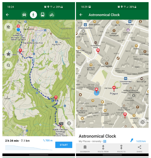
Organic Maps has been released as an Android or iOS [1] | © Organic Maps | map data © OpenStreetMap contributors
Mapping campaigns
- Joachim Eisenberg reported
>
on the first Mapathon hosted by the Federal German Agency for Cartography and Geodesy (BKG).
- Portalaventura commented
>
on the increasing participation of corporate mappers in Brazil, and provided some detailed statistics.
Mapping
- AnuAnakTimur wrote about how he has managed to work around many software changes to continue using Bluetooth GPS receivers to collect tracks and other data for OSM.
- Anton Khorev continued
>
his series of diary posts examining the detailed practicalities of surveying POIs using OsmAnd.
- Hungerburg is concerned
>
, in his blog, about the fact that sometimes in forums it is claimed that the aerial photo must be cited as
source=*at the map object level. This would then affect individual trees, benches, etc. to meet the CC-BY licence of the aerial photo, and why this is not so in his opinion. - Reddit user sporesofdoubt proudly shared the before and after screenshots of the 100th park of their micromapping streak in Phoenix, Arizona.
- The 44th issue of MilpaDigital explains
>
how to use uMap to create thematic and interactive maps based on OpenStreetMap. MilpaDigital is a project aimed at spreading awareness about technological freedom in Central America, the Caribbean and South America.
- Voting on the proposal to standardise
>
Portugal’s localities and administrative boundaries was successfully concluded. The proposal was unanimously accepted, with 13 votes in favour, 0 votes against and 0 abstentions. Thank you for your participation!
- andygol has mapped [ua] the labyrinth in the National Botanical Garden named after M. Grishko with a lot of attention to detail.
- Voting is open for the following proposals:
- three tags according to the scheme
amenity=*_libraryand various subtagslibrary:*=yesfor the growing community of sharers (till Wednesday 23 June). - to complement
man_made=utility_polewithutility=*for poles that do not carry power or telecommunication lines (till Monday 28 June).
- three tags according to the scheme
Community
- User dónal published a detailed diary entry about uploading dashcam imagery to Mapillary, with the hope of inspiring more mappers to experiment and document their experiences on this topic.
- KartaView, previously known as OpenStreetCam, recently shared a post on how to get started with KartaView. If you are new and want to try something interesting, why don’t you give this a try?
OpenStreetMap Foundation
- The OpenStreetMap Foundation is currently looking for a developer to maintain and develop the iD editor.
- The OSM Foundation have published an updated draft of the Attribution Guidelines for comment.
- The OSM Foundation Board will have an ‘Ask me (almost) Anything’ session at the virtual State of the Map next month.
Local chapter news
- Freemap Slovakia, a local chapter of the OSM Foundation, blogged about its activities in Slovakia.
- The Italian local chapter (OSMIt) has extended
>
the services it offers with an instance of Tasking Manager and more OSM data extracts.
Events
- Better support for geo-information is
>
currently the number one desire of the The Wikimedia Deutschland Technical Wishes team and the research phase has been running since the end of last year (we reported earlier). Before moving on to the next phase, a virtual meeting was held on Wednesday 2 June to present the results. Here is
>
a summary of the event.
Humanitarian OSM
- In February HOT hosted a webinar on ‘Colonialism in Open Data and Mapping’ and has now posted a summary of the highlights and takeaways.
Open Data
- You can find recordings from the FOSSGIS conference (held 6 to 9 June) here
.
- Katja Haferkorn and Astrid Emde reported
>
on a successful FOSSGIS conference held online 6 to 9 June.
Software
- [1] Organic Maps has been released as an Android or iOS offline map app for travellers, tourists, hikers, and cyclists based on top crowd-sourced OpenStreetMap data and curated with love by MAPS.ME founders (we reported earlier in #547, #564, and #567).
- This week Mapillary announced various changes to their service which include but are not limited to changes in the login process: Google, Facebook and OSM logins are going to be discontinued in favour of e-mail logins and a few website features such as the sequence editor (aside from blur editing) and web uploader will no longer be available. Android users will be required to download a new app for capturing images. On the upside, Mapillary is going to offer photo filtering based on their age, 3D scenes will be available to browse for all, and a new API has been introduced. To see all the changes visit the Mapillary blog.
Did you know …
- .. the ‘Priceless Map’ shows
>
you places (a table, a shelf, or a store) to drop off things and take or borrow them for free or cheap, such as
amenity=give_box,shop=charity,shop=second_hand, oramenity=toy_library?
Other “geo” things
- With ‘Routago Assist’, Gerd Güldenpfennig and Stefan Siebert have presented
>
a pedestrian navigation system for the visually impaired or blind. In contrast to common navigation systems, which focus on the road network for cars, ‘Routago Assist’ takes into account how pedestrians participate in traffic.
- Maps Mania pointed out that despite NASA having a budget of over USD 22 billion, it is not enough to afford a licence for Google Maps API.
- The graphics chip company NVIDIA is buying DeepMap, a company specialising in collecting very detailed mapping data for use by autonomous vehicles.
Upcoming Events
Note:
If you like to see your event here, please put it into the OSM calendar. Only data which is there, will appear in weeklyOSM.
This weeklyOSM was produced by Anne Ghisla, Climate_Ben, Michael Montani, Nordpfeil, SK53, Supaplex, TheSwavu, derFred, jinalfoflia.