2021/01/26-2021/02/01
畫地圖
- 目前有多個圖徽的提案投票正在進行:
stone_type=ogham_stone用於有歐甘字母銘文的石頭。(時間到 2/8(一));wait=*用於標示需在路口停等的特定車道。(時間到 2/10(三));man_made=tailings_pond指出大量挖礦產生的副產品如液體或是泥巴儲放的地方;打算取代reservoir_type=tailings(時間到 2/10(三));traffic_calming=mini_bumps標記做為交通寧靜化裝置的小型減速丘(時間到 2/11(四));funeral_hall=*來顯示能進行告別式的場所,如葬儀社或是火葬場(時間到 2/13(六));與healthcare=sample_collection標記能夠採集或收件血液、尿液等樣本的地方,之後能進一步在健康檢查時分析(時間到 2/16(二))。
- Brian Sperlongano 提案用於蒸餾水水池的標籤方式,來把固體物質溶解到溶劑當中,或是採集產品,或是處理廢棄物更容易。建議的標籤打算取代原先像是
landuse=reservoir之類的標籤 。 - 終於有針對非郵政商店中提供郵政服務或包裹代收的標籤提案了。目前仍看不大出來如何與其他商店或設施內的郵局如何區分。
- 紐西蘭設計師 Jess Weichler 熱衷於使用 StreetComplete 探索家鄉,並與伴侶度過書呆子約會之夜。
- 使用者 M3232 在 wiki 上提出了圖資與編輯工具如何處理跨對向子午線 (180 W/E) 的問題。
- Ordal 在以色列論壇上寫道關於六日戰爭(第三次以阿戰爭)後佔領的西岸領土
的關係之建議變動,這些變動部份由巴勒斯坦權力機構管理,部份由猶太人定居點管理(由以色列實質管理,但未正式併入)。提議變更的目的是為了更好地反映實際情況。有人可能期望在如此敏感的區域變更會引起回應,但迄今仍無人答覆。
社群
- Rory McCann(使用者 ᚛ᚏᚒᚐᚔᚏᚔᚋ᚜ 🏳️🌈)列出了其2020年11月的個人活動摘要,主要包含了畫地圖、影片、溝通工作小組 (CWG)、社群事務以及 OSMF 理事會。
- Frederik Ramm 指出,在許多語言版本當中,供初學者閱讀的入門 wiki 頁面常已過時。顯而易見,因為這些頁面仍將 Potlach 2 稱為瀏覽器內建的編輯器。他請求說這 45 種語言的人,能夠將初學者入門頁面,將 Potlach 2 修改為另一編輯器。
- Supaplex 說在每月一次的台北月聚上面,與會的資深圖客決議將濫用 MapwithAI 辨識道路的帳號,其繞過限制大量匯入的資料,沒有適當解讀 AI 辨識是否正確。有時 MapwithAI 會將山區將常年無水的乾溪谷,以及高壓電線下的空間,出錯辨識為道路。因此台灣社群決定將這帳號上傳還未被動過的道路全數移除。
匯入
開放街圖基金會
- Mateusz Konieczny 在 OSMF-Talk 郵件論壇上詢問 OSM 基金會的員工列表。目前各種工作由志工與承包商分擔,如專門的 wiki 頁面上所述。
- OpenStreetMap 基金會的自由與開放原始碼軟體 (FOSS) 政策特別委員會已經發佈了一份簡短的報告,其中介紹了組織、理事會與工作小組內部用於協作的軟體工具列表,並提出了關於增加使用自由與開放原始碼軟體的建議。
Local chapter news
- Rory McCann(OSMF 秘書)詢問波蘭 OSM 社群與 OSMF 成員關於波蘭 OpenStreetMap 協會成為 OSMF 的官方在地分會的申請。請在2021年2月14日前提出您的問題、評論或疑慮。
- FOSSGIS 德國分會在1月28日組織了
 >一場名為 FOSSGIS-UPDATE 的完全虛擬活動,活動大成功!超過 200 位與會者在直播中進行演講,並逛虛擬攤位,以及在類似遊戲的小地圖上進行了小組互動。
 - 在 Geomob podcast 的第57集中,Ed Freyfogle 採訪了 Jez Nicholson,他是 OSMUK(OSMF 在英國的在地分會)的其中一位理事。
 >
>
人道救援畫地圖
- Missing Maps 報導了其與無國界醫生在2020年蒲隆地瘧疾掃除運動中的成功協作。Missing Maps 專注於更新關於目標區域中建築物的 OSM 資料。在瘧疾爆發的熱點地區,其中三個社區的滅蚊運動達到了 97% 的人口與 98% 的房屋。
- GIScience 新聞部落格:人道救援畫地圖統計:如何在 HOT 工作管理器中監視人道繪圖?
- 為了加快 PhilAWARE 專案的驗證流程,菲律賓的 HOT 團隊正在為當地志工開放驗證者的選取流程。
教育
- Nixintel 開始在他們的部落格上介紹 Overpass-turbo。
- 聯合國製圖者正在他們的 YouTube 頻道上發佈 OSM 教學課程。其以英語、法語以及義大利語提供。團隊還以多種語言製作訓練教材,這些教材將會放到 Moodle 平台上。如果您有任何意見,或有興趣做出貢獻,請傳送電子郵件到 un.mappers@un.org
地圖
- 來自開放原始碼使用者 Wheregroup 的 Marcel Normann 也解釋了>關於發起 MapLibre 的一些背景資訊(我們先前報導過了)。
- Delphine Montagne 在 talk-fr 郵件論壇上通知我們>,關於出版一幅波城生態轉型的互動地圖的資訊。該地圖是 TREE 實驗室(CNRS/波城大學)DéCiSiF> 專案的成果。資料來自 OpenStreetMap 和 INPN>(國家自然遺產目錄)。
 >
>軟體
- 根據現實世界的地理位置自行建造並營運鐵路路線的遊戲 NIMBY rails 已經釋出。這款遊戲是以 OSM 為基礎,遊戲選單有 27 種語言版本了。
- SomeoneElse 報告了他在各種 Linux 散佈版在 Wine 下執行 Potlatch 3 的實驗。在大多數情況下,這些實驗是成功的的。他提出了一些具體的建議,以避免可能造成編輯遺失的當機。
程式開發
- IpswichMapper 在 Talk 郵件列表上公佈了 SwiftAddress(請參閱先前的報導)。Simon Poole 回應提出了 OSM 軟體開發中的 “doppelspurigkeit” 問題。這又引發激烈討論要來下決定,決定要開發新軟體或是改寫現有程式碼。
- Branko Kokanovic 撰寫了一個新的終端機 app,其使用了 GTFS 作為輸入來源,並告訴您 OSM 中需要進行的變更,以使其儘可能接近 GTFS。原始碼可在 GitLab 上找到。
- 在本週舉辦的 osm2pgsql 虛擬聚會之前,Sven Geggus 列出了他們的願望清單 (desiderata)。
釋出
- OpenStreetMap Carto 渲染現已發佈 5.3 版。視覺上的重大變化是小型圓環的繪製方式,小型圓環現在看起來更接近轉動的圓圈。其他變動(如航道上的部份索引)僅僅是為了改善效能。
- OpenMapTiles 發布了新的版本 (3.12),其中包括一些新的功能。例如將建築物概括為塊狀,旨在改善中間縮放等級的密集城市區域的彩現效果。新增加的功能包括水域(游泳池、鹽池等)、機場大門和保護區。
- OsmAnd 已釋出 3.90(iOS 版)與 3.9(Android 版)。
- 超快速的 OpenStreetMap 導航計算引擎,OSRM 釋出新版本,支援了多種通行限制、相容於 Node 14、Lua 設定檔除錯指令腳本以及修復許多臭蟲!
你知道嗎?
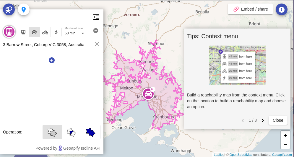
- ……通勤時間地圖允許你為不同交通方式創建可及性地圖?
- ……OSM 歷史紀錄檢視程式視覺化了開放街圖物件歷史紀錄,並連結到各種其他的 OSM 監視工具?
- ……James Westman 製作的全球 OSM 即時變更集?幾乎每秒都會顯示新的變更集。即而將達到一億次變更集,Weekly 團隊正在計畫下一期弄出一些東西。
- ……開放 GIS 產品的概覽,可在 OSGeoLive 的專案統計中找到?在大多數的例子中都能正確顯示整個開發過程中的活動、使用的程式語言與開發團隊等統計資訊。iD 就是其中一個代表。不幸的是,JOSM 在 Open Hub 上有點問題。
- ……Routeshuffle 讓您只要點幾下就可以建立用於跑步、走路或騎自行車的隨機路線?您只需要輸入起點即可,可以是地名或座標,您希望的路線長度與運動種類。
- ……您可能會永遠困在圓環裡?
媒體中的 OSM
其他地理事情
- 您是否試過我們在年初報導過的威廉國王學院測驗?現在您可以檢視您的答案是否正確了。事實證明,尤其有助於全面了解英文小說中提及的美國各州首府、索美塞特郡、科茲窩、肯亞、都柏林與印度的地理。
- 缺乏地理知識是一件危險的事情。對情境知識的缺乏導致 Facebook 將著名的英文地點名稱標記為令人反感的詞語。
- 迦納的林業委員會 (FCG) 最近公佈了《國家森林與土地利用地圖》。代表了迦納致力於建立地球觀測專業知識的重要里程碑。可在此檢視地圖。
- Fabian Kowatsch 繼續了關於使用 ohsome 分析路網的一系列部落格文章(我們先前已經報導過第一部份了)。本週,他們研究了已加入
maxspeed標籤與未加入此標籤的道路長度比。 - Alex Donaldson 向讀者介紹了 Google 地圖中新增的功能,這些功能可以協助電動車的擁有者。現在計算導航路線時會考慮合適的充電站與付款方式在內了。
未來活動
| 地點 | 活動名稱 | 線上 | 日期 | 所在國 |
|---|---|---|---|---|
| OSMF Survey 2021 | 2021-01-25 – 2021-02-14 | |||
| Missing Maps DRK Online Mapathon | 2021-02-09 | |||
| Hamburg | Hamburger Mappertreffen | 2021-02-09 |  | |
| München | Münchner OSM-Stammtisch | 2021-02-10 | | |
| Hacking JOSM EasyPresets (Hungarian) | 2021-02-10 | |||
| Osborne County | OpenStreetMap U.S. Virtual Mappy Hour | ✓ | 2021-02-11 |  |
| Zürich | OSM-Treffen Zürich | 2021-02-11 |  | |
| Chippewa Township | OpenStreetMap Michigan Meetup | ✓ | 2021-02-12 | |
| Berlin | 152. Berlin-Brandenburg OpenStreetMap Stammtisch (Online) | 2021-02-12 | | |
| Lyon | Rencontre mensuelle (virtuelle) Lyon | ✓ | 2021-02-16 |  |
| Berlin | OSM-Verkehrswende #20 (Online) | 2021-02-16 | | |
| 136. Treffen des OSM-Stammtisches Bonn | 2021-02-16 | |||
| Lüneburg | Lüneburger Mappertreffen (online) | 2021-02-16 | | |
| Albuquerque | MapABQ February virtual meetup | 2021-02-18 | | |
| Stammtisch Köln | 2021-02-17 | |||
| San Jose | Virtual Civic Hack & Map Night | ✓ | 2021-02-19 | |
| Bremen | Bremer Mappertreffen (Online) | 2021-02-22 | | |
| Ville de Bruxelles – Stad Brussel | Virtual OpenStreetMap Belgium meeting | ✓ | 2021-02-23 |  |
| Osborne County | OpenStreetMap U.S. Virtual Mappy Hour | ✓ | 2021-02-25 | |
| 臺北市 | Open Data Day Taiwan 2021 | 2021-03-06 |  |
註: 你也可以在這裡展示你發起的活動!只須在行事曆上塡妥活動資訊即可。 只有記載於行事曆上的活動資訊才會在《週刊OSM》列出。你也可以在行事曆預覽檢查你提交的活動, 並作出適當更正。
這期 weeklyOSM 由 Nordpfeil, rogehm, SK53, Sammyhawkrad, Supaplex, TheSwavu, derFred, s8321414 編譯 ##team##
Juste un petit merci !