2019/10/08-2019/10/14
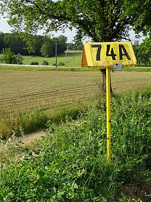
水道管などの埋設場所を示すマーカーのタグが投票中です1 | © Pyrog – Creative Commons Attribution-Share Alike 4.0 International
マッピング
- MapRouletteチームはサービスのドキュメントが刷新されたことをツイートし、フィードバックと協力者を求めています。
- DWGのFrederik Ramm氏は米国で議論になっている「公園」について意見を求めています。
- スクリプトによってスーパーマーケットに
cash_withdrawal=タグを追加するというMichael Brandtner氏の提案は、ドイツのメーリングリストとフォーラムで様々なフィードバックを受けました。 - John Kennedy氏は既に存在する境界リレーションから簡単に新しい境界リレーションを作成するためのJOSMプラグインRelationDissolveを作成しました。既にある境界リレーションを結合させると、それらが共有しているウェイが自動的に新しいリレーションから除外されます。
- ChameleonScaless氏の提案したタグ付け、
amenity=toy_libraryへの投票が始まりました。投票は10/27までです。トイ・ライブラリーはゲームやおもちゃは貸し出しますが、本は貸し出しません。 - 都市ガス管、電気設備、水道管などの埋設位置が分かるように地上に設置するマーカーをタグ付けする
maker=*が投票中です(10/26締め切り)。
OpenStreetMap Foundation
- 少額支援プログラムがコミュニティへの相談がないまま承認されたことについて、Michael Reichert氏がOSMF理事会に尋ね、Joost Schouppe氏が回答しました。
- 10/9に開催された地方支部ワーキンググループ会議の議事録草案がOSMF Wikiに公開されました。
イベント
- Ilya Zverev氏は地域ごとにマッピングにどのような違いがあるかを調べるため、アンケートを用意して回答を求めています。アンケート結果は10/25~27にプリズレン(コソボ)で開催されるSotM 東南ヨーロッパで発表されるそうです。
- Imagico氏がSotMのレポートを公開しました。会議の内容だけでなく、会場の使いやすさ、参加者や奨学生の偏り、国際SotM開催を止める可能性などについても考察されています。
- GIS分野に興味ある人々が情報交換することを目的とした第5回ウィーンGeo Meetupが10/29に開催されます。
- ロシアで初めてのMissing Mapsマッパソンが10/12にモスクワで開催されました。2.5時間で36人の参加者がジンバブエ南部にあるバイトブリッジ州の86%をマッピングしました。
OSM人道支援
- 10月13日は#DisasterRiskReductionの国際デーでした。ハイデルベルク大学GIS研究グループHeiGITは国際デーを祝してHeiGITが人道支援活動向けに開発したツール類を紹介するブログを公開しています。
教育
- kaggle.comでは無料の地理空間分析学習テキストを公開しています。レッスンにはPythonで地理空間データを簡単に操作するためのライブラリ、GeoPandasについてのレッスンが含まれています。
地図
- OSMベースのPillion mapsではオートバイ駐輪場を探すことができます。
switch2OSM
- ロシアで道路の不具合等を報告できるポータルサイト115.белが新しくなり、背景地図にOSMが使われるようになりました。
ライセンス
- Facebook社の地図でOSMの帰属表示が不十分であるとして、OSMFメーリングリストで議論されています。なお現在帰属表示方法に関するガイドラインが策定中であり、もうすぐ正式版が出ると思われます。
プログラミング
- Brian DeRocher氏がOSMウェブサイトにローカルグループ機能を追加するために「巨大」なプルリクエストを送り他の開発者を驚かせています。
ご存知でしたか?
- デジタルマップ市場に関する有料レポートでは、OSMがトッププレイヤーのひとつに挙げられています。
- wambacher氏のウェブサイトOSM Boundaries Mapでは国境や行政界などの境界データをエクスポートできます。
- OpenPlaquesにはホロコーストで犠牲になった人を悼む「つまずきの石」の場所が地図上に載せられています。
- 英国のパブの名前は、例えば「色+名詞」のような一定の命名規則があり、”Red Lion”という名前のパブは339軒あります。Pub Crawl Generatorを使うと、同じ名前のパブを全制覇するルートを検索することができます。
メディア掲載
- ポケモンGOはギリシャのサラミス島ではプレイできない状態が続いていました。島全体に
natural=bayのタグが付けられていた事で、ゲームはこの島が水中にあると解釈していた事が原因です。OSMのデータ修正後もポケモンGOのデータは更新されていなかったのですが、 Niantic はデータの解釈方法を変更し、現在はポケモン達が戻ってきているようです。
その他の “ジオ” な事柄
- ガーディアン紙は地球上の全ての土地をレーザースキャンしてデジタル保存するEarth Archiveを紹介しています。この計画はライダー計測器を載せた航空機を使い、世界中の文化的、環境的、地質学的に貴重なものを保存することを目的としています。20cm解像度の三次元データをスキャンするためにはおよそ1500万ドルの費用がかかるそうです。
- スコットランド国立図書館が所有する古地図を地理参照プログラムを介して利用する方法についてChris Fleet氏が論文を書きました。なお同古地図はOSMコミュニティも利用可能です。
- ウェブサイトGeospatial WorldがGoogleマップの進化を解説する記事を公開しました。この記事はGoogleマップが登場した2005年から順に解説していますが、登場当時の状況はあまり詳しく説明されていません。
- カリフォルニア州では山火事を防ぐため、計画停電が実施されています。電力供給会社パシフィック・ガス・アンド・エレクトリックは停電の情報を公開していますが、地図ではなくシェープファイルでの公開でした。この公開方法は批判を受けていますが、サンフランシスコ・クロニクルがLeafletを使って見やすい地図を作成しました。
- Pratyush Tripathy氏とTeja Malladi氏がSentinel-1衛星写真を使って洪水範囲をマッピングした結果を報告しています。このようなマッピングにより救助活動の支援が可能であると考えています。なお作成した地図にはOSMが使われていますが、適切な帰属表示がありません。
- 豪州地理科学局は、地形図の印刷物販売を停止することを発表しました。
- Garminの新機種OverlanderにはOSM地図がプリインストールされています。
- Chris McDowell氏およびTim Denee氏がニュージーランドの地理情報を様々な視点で可視化した書籍を出版しましたが、データの解析に使われているプログラムがGithubで公開されています。
まもなく開催
| 場所 | 名称 | 開催日 | 国 |
|---|---|---|---|
| アルロン | Espace public numérique d’Arlon – Formation Contribuer à OpenStreetMap | 2019-10-16 |  |
| ベルリン | Missing Maps Mapathon – Putting the Wolds’s Vulnerable People on the Map | 2019-10-17 |  |
| Vienna | 63. Wiener Stammtisch | 2019-10-17 |  |
| カールスルーエ | Karlsruhe Hack Weekend | 2019-10-19-2019-10-20 | |
| ソルトレイクシティ | OSM Utah Mapping Night | 2019-10-22 |  |
| ノッティンガム | Nottingham pub meetup | 2019-10-22 |  |
| ジリナ | Missing Maps Mapathon Žilina #6 | 2019-10-22 |  |
| アルロン | Espace public numérique d’Arlon – Formation Les itinéraires balisés et OpenStreetMap | 2019-10-23 | |
| リューベック | Lübecker Mappertreffen | 2019-10-24 | |
| サンホセ | Civic Hack & Map Night | 2019-10-24 | |
| プリズレン | State of the Map Southeast Europe | 2019-10-25-2019-10-27 |  |
| Rapperswil | 11. Micro Mapping Party Rapperswil (OpenStreetMap Mapathon) | 2019-10-25 |  |
| 与謝野町 | 京都!街歩き!マッピングパーティ:第13回 ちりめん街道 | 2019-10-27 |  |
| ブレーメン | Bremer Mappertreffen | 2019-10-28 | |
| デュッセルドルフ | Stammtisch | 2019-10-30 | |
| Ulmer Alb | Stammtisch Ulmer Alb | 2019-10-31 | |
| ダッカ | State of the Map Asia 2019 | 2019-11-01-2019-11-02 |  |
| ブルノ | State of the Map CZ+SK 2019 | 2019-11-02-2019-11-03 |  |
| シュトゥットガルト | Stuttgarter Stammtisch | 2019-11-06 | |
| ウェリントン | FOSS4G SotM Oceania 2019 | 2019-11-12-2019-11-15 |  |
| エンカルナシオン | State of the Map Latam 2019 | 2019-11-14 |  |
| グラン・バッサム | State of the Map Africa 2019 | 2019-11-22-2019-11-24 |  |
| ケープタウン | State of the Map 2020 | 2020-07-03-2020-07-05 |  |
‘
Note: ここであなたのイベントを見たい場合は、カレンダーにそれを 入れてください。そこにあるデータのみが、週刊 OSM に表示されます。 カレンダー 内で都市や国に言及するのを忘れないでください。
This weeklyOSM was produced by Nakaner, Rogehm, SunCobalt, TheSwavu, derFred, k_zoar, anonymus, muramototomoya.