28/12/2021-03/01/2022
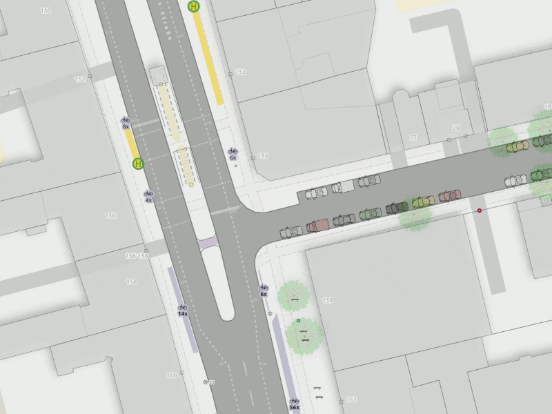
Showcase of detailed mapping in the traffic area in Berlin-Neukölln [1] | © Straßenraumkarte | map data © OpenStreetMap contributors
Mapping campaigns
- Marjan, from TomTom, informed us of the project they have planned in the Dominican Republic (similar to those they have carried out in many other countries). They compared their data with the data in OSM and opened a MapRoulette Challenge to check the missing roads.
Mapping
- A Taiwan mapper 琉璃百合, mentioned
 > the traffic light tagging issue in the Talk-cn mailing list. She believes that some Chinese mappers incorrectly tag traffic lights at road intersections, and gave some proper examples.
 - DeBigC had set targets for 2021, which he reviewed at the end of the year, and set his OSM targets for 2022. His summary is provided with interesting links.
- User Bxl-forever made the first changeset of 2022 (UTC) according to OSMCha.
- Martin Wieland, from the unsurv project, has set himself the task of compiling a database of already installed video cameras that is as up to date as possible. Tools for the largely automatic mapping of such electronic eyes are to help with this project.
- Jeremy G describes in his OSM Diary the process he used in adding the ‘industrial trail walk’ at l’Argentière-La Bessée in France as a relation.
- Johnwhelan detected a lot of mistakes after some completed projects in the HOT Tasking Manager which did not have appropiate validation and made some recomendations on how to clean up after completing a project in the tasking manager.
- The proposal
amenity=small_vehicle_parking, to tag parking locations of any kind of small road vehicle, apart from bicycles, is waiting for your comments.Voting is open fordefensive_works=*, to tag military constructions or buildings designed for the defence of territories in warfare, until Tuesday 18 January.
 >
> 
 in his OSM Diary the process he used in adding the ‘industrial trail walk’ at l’Argentière-La Bessée in France as a
 Community
- 48 contributors mapped every single day in 2021. Interested in more statistics? Just have a look at OSMStats by Pascal Neis.
- User AndreyGeograf wrote > about his experience with micro and nano mapping.
- Janet Chapman reported on her experience with six years of ‘Crowd2Map‘.
- OpenStreetMap Belgium’s Mapper of the Month for January is Koos Krijnders from The Netherlands.
- As a response to an article titled ‘Should you fix errors and contribute to Google Maps for free?’ Cj Malone wrote an article providing insights about contributing open data to OpenStreetMap for free.
 >
> Local chapter news
- Cartographers from the Digne area in France wrote > about naming and tagging practices for pedestrian trails and how different renderers show them.
Maps
- [1] Alex (user Supaplex030) continued to explore the boundaries of the level of detail that can be rendered based on OSM data with his public space map for Neukölln, Berlin. A blog post by Tobias Jordans shows many interesting details such as cycleways, turn lanes and junctions and explains how the data is processed to allow this rendering. One conclusion is that a collaboration on pre-processed OSM data for streets would be of huge benefit.
- Reddit user burgerking_foot shared a map showing places named Å from Katapult. Funnily enough, all of them are distributed in northern Europe.
Software
- The software Flatmap has been renamed to Planetiler. Working in a similar way to Tilemaker it allows production of OSM-based map files in Mapbox Vector Tile format (MVT).
- OpenMobilityIndicators has been extended > to the whole of France. The toolbox uses OpenStreetMap data to measure pedestrian accessibility in a given area.
- qeef wrote about the second year of ‘Divide and map. Now.‘, which, as an example, enabled a simultaneous mapathon of 200 mappers by dividing up an area.
Releases
- Dietmar Seifert has provided an analysis of how many addresses in Germany are already mapped in OpenStreetMap.
 an analysis of how many addresses in Germany are already
 Did you know …
- … of the many ways to get in touch with the OSM community?
Where can I get help, where can I find people to talk to? ### International – Multilingual Channels * International mailing lists * Forum from Android to Wiki team and from Albania to Venezuela * Discord * Mastodon * Matrix * Slack * Telegram * Twitter * IRC channels
OSM in the media
- Effective 1 January 2022, a total of 10 towns in Poland have been granted > city status. As happens every year, the required changes have been implemented promptly by Polish mappers.
 >
> Upcoming Events
| Where | What | Online | When | Country |
|---|---|---|---|---|
| OSM Africa Monthly Mapathon: Map Mauritania | 2022-01-08 | |||
| 臺北市 | OpenStreetMap x Wikidata Taipei #36 | 2022-01-10 |  | |
| OSMF Engineering Working Group meeting | 2022-01-10 | |||
| München | Münchner OSM-Treffen | 2022-01-11 |  | |
| Helechosa de los Montes | Reunión mensual de la comunidad española | 2022-01-11 |  | |
| Michigan | Michigan Meetup | ✓ | 2022-01-13 |  |
| Berlin | 163. Berlin-Brandenburg OpenStreetMap Stammtisch | ✓ | 2022-01-13 | |
| Bochum | OSM-Treffen Bochum (Januar) ONLINE | 2022-01-13 | | |
| Lyon | EPN des Rancy : Technique de cartographie et d’édition | 2022-01-15 |  | |
| Hilversum | OSGeo.nl/OSM-NL/QGIS-NL Nieuwjaars Borrel | 2022-01-16 |  | |
| San Jose | South Bay Map Night | ✓ | 2022-01-19 | |
| 147.Treffen des OSM-Stammtisches Bonn | 2022-01-18 | |||
| Bremen | Bremer Mappertreffen (Online) | ✓ | 2022-01-24 | |
| Hoeselt | Rode Kruis Mapathon – Hoeselt | 2022-01-25 |  | |
| Düsseldorf | Düsseldorfer OpenStreetMap-Treffen (Online) | 2022-01-26 | | |
| Missing Maps online Mapathon des DRK | 2022-01-26 |
Note:
If you like to see your event here, please put it into the OSM calendar. Only data which is there, will appear in weeklyOSM.
This weeklyOSM was produced by Lejun, Nordpfeil, PierZen, SK53, Sammyhawkrad, Strubbl, TheSwavu, derFred, miurahr, 快乐的老鼠宝宝.