27/12/2022-02/01/2023
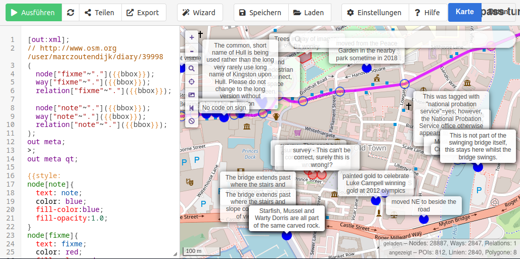
marczoutendijk’s Overpass query to locate fixme tags [1] | © marczoutendijk | map data © OpenStreetMap contributors
Mapping
- TrickyFoxy wrote, on telegra.ph, an article on ‘Why you should try Every Door’.
- Requests have been made for comments on the following proposals:
emergency=fire_water_inletfor mapping an inlet to a building’s firefighting system.place=seato deprecate the use of a closed way or multipolygon to map a marginal sea or named portion of an ocean in favour of using aplace=seanode.shop=yarnto tag a business primarily selling yarn and supplies for knitting or crochet.
Mapping campaigns
- [1] The new quarterly project for the UK has started. The UK community will be working on
fixmeand Notes over the next three months.
Community
- feyeandal highlighted the contributions of university clubs with local chapters of YouthMappers in the OSM-Philippines community in 2022 and shared a short reflection about the impact of YouthMappers in a local context.
- A new ‘Communities’ tab has been added to the main page of openstreetmap.org. You can see it in the upper right corner. The tab links to a single location that lists formal Local Chapters, as well as the other OSM communities. Read more about its background on the OpenStreetMap blog.
- On the request of Andrii Holovin, the OSM Ops Team created a short URL for community.openstreetmap.org. The quiz we reported on last week could now be extended with c.osm.org.
- OSM Belgium announced their mapper of the month: lusdavo.
OpenStreetMap Foundation
- The OSMF OWG (Operations Working Group) has published their spending plan for 2023.
Events
- jomo participated in the Fireshonks conference in December where he talked about how to improve skills and knowledge in the OSM ecosystem. He showed various editors, validators, parsers and other tools for both general and more specific purposes and also shared some tips and tricks that he has learned during several years of OSM mapping.
Maps
- Raster map provider Tracestrack announced that they have started to render country-specific motorway shields. Shield reference text is selected randomly from
ref,nat_refandint_ref. The style can be explored via Map Explorer.
Open Data
- Microsoft released new data on missing roads based on fresh (2020–2022) aerial imagery.
- mmd has wiki’ed blog posts from various people in the OSM community in a very long thread on Overture and asks others to make additions.
Software
- Victor Shcherb (CEO of OsmAnd) published the OsmAnd 2023 ‘New Year Resolutions’.
- IzzyOnDroid tooted that the Every Door editor has made it to the Android app store F-Droid.
- Overpass Ultra is a fork of the popular tool overpass turbo. The developers note that ‘because it uses MapLibre GL JS instead of Leaflet, it can be used to visualise significantly larger Overpass API results than overpass turbo’.
- In his diary, Jiri Vlasak (qeef) summarised what happened in the development of Divide and map. Now. over the last year, and outlined the plans for 2023. Divide and map. Now. helps mappers by dividing a big area into smaller squares that people can map together.
Programming
- Xavier Olive released Cartes, which is a ‘Python library providing facilities to produce meaningful maps’. Xavier provides documentation and an Anaconda Python package.
- Gero Gerke started a series of blog posts about implementing an OpenStreetMap data vector renderer using WebGL.
- RGCosm is a new minimal ‘Reverse Geocode for OpenStreetMap’. According to the developer’s Hacker News announcement: ‘ChatGPT wrote most of the code for me. Created it in about three hours, where the time is combined with creating the DB, and testing it with the rest of the code for a different project’ (sqlite3 + python + pyosmium).
- richlv linked to his script that brings back Mapillary’s vanished feature to create a GPX file from image sequences.
- A small update to the openstreetmap.org website now makes it possible to verify your OSM user account on Mastodon. A toot by Pieter Vander Vennet explains how to do this.
Did you know …
- … this map of Russian river basins
 ?
? - … the monthly Geotrivia game hosted by OpenCage on Mastodon? The next game is scheduled for 27 January 2023.
 ?
?Other “geo” things
- The Bomann Museum in Celle (Germany) is hosting ► the exhibition ‘Die wahre Vermessung der Welt’ (The True Measurement of the World) about the mapping of the Kingdom of Hanover by Carl Friedrich Gauss. The exhibition runs until 30 May 2023.
- Google is working on an Apache-2.0 licensed project named forma, which is a ‘parallelised experimental Rust vector-graphics renderer’. One of their examples is to render a big SVG of Paris nearly instantly. Bert Temme shared videos of the renderer’s speed by comparing the Chrome Browser with forma.
 ►
►
Upcoming Events
| Where | What | Online | When | Country |
|---|---|---|---|---|
| København | OSMmapperCPH | 2023-01-08 |  | |
| OSMF Engineering Working Group meeting | 2023-01-09 | |||
| Stuttgart | Stuttgarter Stammtisch | 2023-01-10 |  | |
| München | Münchner OSM-Treffen | 2023-01-10 | | |
| Salt Lake City | OSM Utah Monthly Map Night | 2023-01-12 |  | |
| Berlin | 175. Berlin-Brandenburg OpenStreetMap Stammtisch | ✓ | 2023-01-12 | |
| Seattle | World Railway Mapping Online Quarterly Meetup. | 2023-01-14 | | |
| 159. Treffen des OSM-Stammtisches Bonn | 2023-01-17 | |||
| London | Geomob London | 2023-01-18 |  | |
| Karlsruhe | Stammtisch Karlsruhe | 2023-01-18 | | |
| Dar es Salaam | State of the Map Tanzania | 2023-01-19 – 2023-01-21 |  | |
| Budapest | Hiking by the pipeline between Normafa-Stop Shop-Aranyvölgy | 2023-01-21 |  | |
| Toulouse | Réunion du groupe local de Toulouse | 2023-01-21 |  | |
| Downtime | 2023-01-22 | |||
| Bremen | Bremer Mappertreffen (Online) | 2023-01-23 | | |
| Düsseldorf | Düsseldorfer OpenStreetMap-Treffen | ✓ | 2023-01-25 | |
Note:
If you like to see your event here, please put it into the OSM calendar. Only data which is there, will appear in weeklyOSM.
This weeklyOSM was produced by MatthiasMatthias, PierZen, SK53, Strubbl, TheSwavu, derFred, tordans.
We welcome link suggestions for the next issue via this form and look forward to your contributions.