07/02/2023-13/02/2023
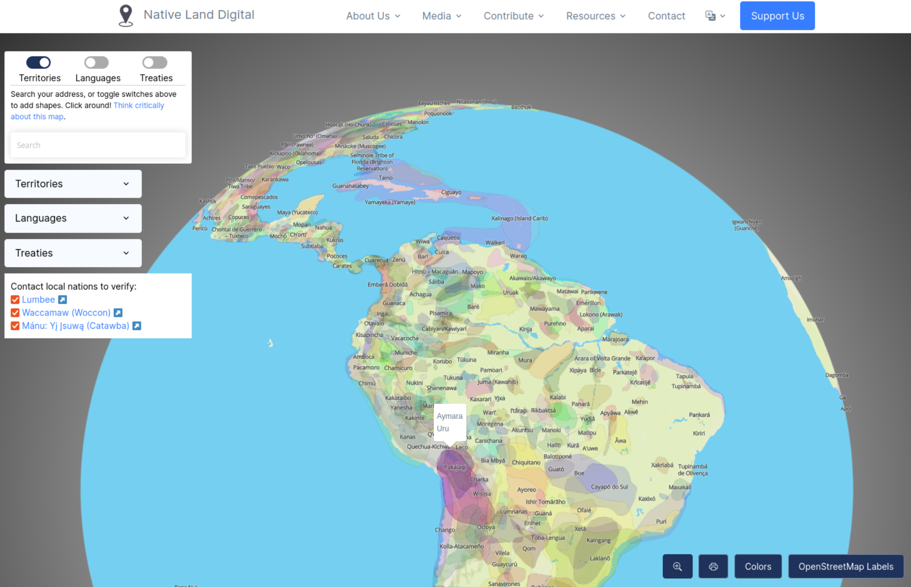
The Native Land Digital globe showing Native Territories as they were historically [1] | © Screenshot of Native Land Digital | map data © OpenStreetMap contributors
Mapping
- Requests have been made for comments on the following proposals:
amenity=showgroundto describe open areas (typically grassy or gravel) which are maintained to be used for outdoor events.landcover=*version 2 to formalise the usage of the keylandcover=*and deprecate the tagslanduse=grassandlanduse=flowerbed.
- Voting is currently open until Friday 24 February for:
emergency=air_rescue_service, for tagging buildings and base areas of those groups that use aircraft for either aerial search and rescue or medical evacuation purposes.emergency=water_rescue, for mapping the buildings and base areas, both on and off water, of those groups that are dedicated to the rescue of vessels and/or sailors in distress.emergency=fire_water_inlet, for mapping an inlet to a building’s firefighting system.
Community
- Martijn van Exel has sent out the final OSM Tips email (we reported earlier). After a three month trial Martijn has decided to invest more time on MapRoulette in the future.
- MoiraPrime reflected on the current state of the map in Mississippi and concluded that the issues identified can be fixed with the help of the community. She listed a number of ways to get in touch with the Southern US community.
OpenStreetMap Foundation
- The OSMF Engineering Working Group has decided that the call for proposals to add the ability to mute users on the openstreetmap.org website (we reported earlier) will close on Monday 13 March.
Events
- About a year ago, Martin Raifer started working as the maintainer of the iD editor for the OSMF (we reported earlier). He has blogged a short recap and outlook of what’s lying ahead according to him. He wants to host regular online community sessions to chat about the iD editor. The first of these chats will take place on 20 February at 4 pm UTC with the topic ‘the state of the tagging presets – recent changes and development tips’.
- Ilya Zverev announced that SOTM Baltics 2023 will be held in Riga on 18 and 19 May, where OSM-Baltic will join with the BalticGIT organisation team, the same arrangement as three years ago. This will give everyone interested in open data and open tools an opportunity to gather together to present their work, meet other mappers and developers, and spend two days in a beautiful city on a super wide river.
Education
- While training in French for beginners has already started (‘OpenStreetMap and Humanitarian Mapping’, which we reported in #651 and #655), the UN Mappers announced that this free training will also be provided Portuguese starting Wednesday 22 March. All interested Portuguese speakers are invited to register.
- Christian Hollinger encouraged beginners to get a handle on QGIS, for everything from basic data to elevation data and inserting photos. There is a lot for newcomers.
Humanitarian OSM
- Heather Leson, Dinar Adiatma, and Can Unen shared links to help new and experienced mappers get started with HOT mapping in Turkey.
- pedrito1414 addressed the question ‘is what I am doing really helping anybody in a disaster situation?’ with some statistics. The answer is yes.
Maps
- Alan McConchie interviewed Tanya Ruka, a Māori indigenous multimedia artist and designer who is the new Executive Director of Native Land Digital, an organisation with the mission ‘to map Indigenous lands in a way that changes, challenges, and improves the way people see history and the present day’.
Software
- MapTiler now has an Ocean map style available on MapTiler Cloud. The 15 arc-second elevation dataset provided by GEBCO was processed into an optimised Ocean tile set.
Other “geo” things
- In the latest edition of OpenCage’s #geoweirdness, even a Brazil specialist is sure to find some more interesting facts.
- The MapScaping Podcast recently discussed how AI can be used to generate artificial satellite imagery using generative adversarial networks (GANs). They tweeted four lookalikes – are you able to tell which is fake?
- Five days after the Turkey–Syria earthquakes, researchers have produced a map of the ground movement along the East Anatolian Fault. They did this by using before and after data from the EU’s Copernicus Sentinel-1A satellite, which carries a synthetic-aperture radar instrument that is able to routinely sense changes in elevation of the Earth’s surface. Neither of the two most serious earthquakes here were limited to a single epicentre; the first was a 300 km long rupture in one fault and the second a 140 km long one in another.
- Matthew Beedham drew an analogy between Overture Maps Foundation’s aim to develop standards for interoperability and shipping containers.
Upcoming Events
| Where | What | Online | When | Country |
|---|---|---|---|---|
| Budapest | Hiking by the pipeline towards Százhalombatta | 2023-02-18 |  | |
| Nairobi | Mapping for Türkiye and Syria | 2023-02-18 | ke | |
| Bologna | Wikigita alla Certosa di Bologna | 2023-02-18 |  | |
| Toulouse | Réunion du groupe local de Toulouse | 2023-02-18 |  | |
| iD monthly meetup | 2023-02-20 | |||
| OSMF Engineering Working Group meeting | 2023-02-21 | |||
| Lyon | Réunion du groupe local de Lyon | 2023-02-21 | | |
| 160. Treffen des OSM-Stammtisches Bonn | 2023-02-21 | |||
| Lüneburg | Lüneburger Mappertreffen (online) | 2023-02-21 |  | |
| HeiGIT Sketch Map Tool Launch | 2023-02-22 | |||
| Berlin | Missing Maps – DRK & MSF Online Mapathon | 2023-02-22 | | |
| Düsseldorf | Düsseldorfer OpenStreetMap-Treffen | 2023-02-22 | | |
| Wien | 67. Wiener Stammtisch | 2023-02-22 |  | |
| [Online] OpenStreetMap Foundation board of Directors – public videomeeting | 2023-02-23 | |||
| Lajoux | OpenStreetMap : la cartographie collaborative pour tous | 2023-02-24 | | |
| Lajoux | OpenStreetMap : la cartographie collaborative pour tous | 2023-02-25 | | |
| Karlsruhe | Karlsruhe Hack Weekend February 2023 | 2023-02-25 – 2023-02-26 | | |
| IJmuiden | OSM Nederland bijeenkomst (online) | ✓ | 2023-02-25 |  |
| Junta bimestral OSM-LatAm | 2023-02-25 | |||
| Understanding the Basics of OpenStreetMap | 2023-02-25 – 2023-02-26 | |||
| Bremen | Bremer Mappertreffen (Online) | ✓ | 2023-02-27 | |
| Swarzędz | Workshops for new users – improve the space around you virtually | 2023-02-28 |  | |
| San Jose | South Bay Map Night | ✓ | 2023-03-01 |  |
| Stuttgart | Stuttgarter Stammtisch | 2023-03-01 | | |
| England | OSM UK Chat | ✓ | 2023-03-02 |  |
| Budapest | Hiking by the pipeline between Barosstelep and Albertfalva | 2023-03-04 | | |
| 泉大津市 | マッピングパーティーin泉大津 | 2023-03-04 |  | |
| 荒尾市 | 地域の「今」を記録して残そう! みんなで作る! みんなが使える無料のマップ ~変わりゆく荒尾~ | 2023-03-05 | | |
| MapRoulette Monthly Community Meeting | 2023-03-07 | |||
| Missing Maps London Mapathon | 2023-03-07 | |||
| Stainach-Pürgg | 8. Virtueller OpenStreetMap Stammtisch Österreich | 2023-03-08 | | |
| Salt Lake City | OSM Utah Monthly Map Night | 2023-03-09 | | |
| München | Münchner OSM-Treffen | 2023-03-09 | | |
| Winterthur | OSM-Stammtisch @Init7 | 2023-03-10 |  |
Note:
If you like to see your event here, please put it into the OSM calendar. Only data which is there, will appear in weeklyOSM.
This weeklyOSM was produced by MatthiasMatthias, PierZen, SK53, SeverinGeo, SomeoneElse, Strubbl, TheSwavu, barefootstache, derFred.
We welcome link suggestions for the next issue via this form and look forward to your contributions.
Wo finde ich die aktuelle Abstimmung?
Die Tags sind mit den Abstimmungen verlinkt. Ganz unten befindet sich das Unterkapitel “Voting”.
`=fire_water_inlet` has been changed to `=fire_service_inlet`
Thank you for pointing out this change.
Hello WeeklyOSM, could you please help add State of the Map Africa 2023 on the list of upcoming events for 2023 https://osmcal.org/event/1842/
We added it to the OSM Calendar a long time ago but it does not appear here
Hi Geoffrey, the calender in the WN is generated. It contains the events in the upcoming four weeks. So, SotMA will only be in this WN calender approx. starting from November, because the event in the beginning of December.
If you have a link that should be published in the weekly – you can propose it, please see https://weeklyosm.eu/this-news-should-be-in-weeklyosm
Hi Geoffrey,
Before the OSM Calendar existed in its current form, weeklyOSM had always been able to read out the short-term data and the long-term data. This is no longer possible since the new OSM Calendar.
If you want to have this, you have to contact the creators of the OSM Calendar.
weeklOSM would also like it very much if we could show the long-term dates separately again.