14/02/2023-20/02/2023
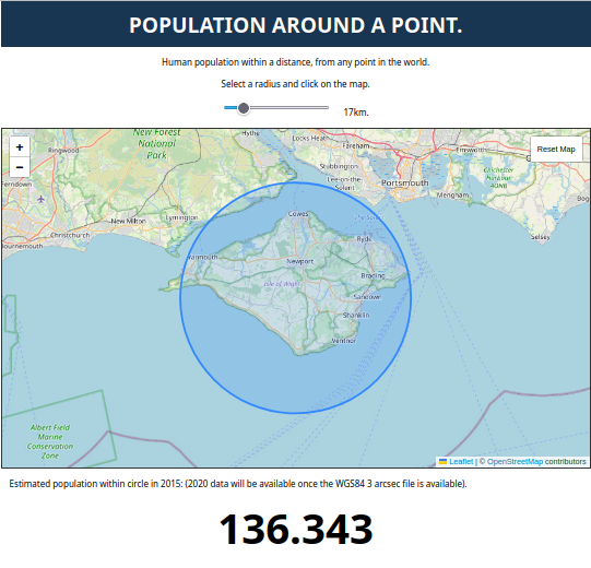
Estimated population around a Point [1] | © Tom Forth Creative Commons Licence BY 4.0 | map data © OpenStreetMap contributors
Mapping
- Anne-Karoline Distel has spent a very interesting, challenging and turbulent four weeks mapping the National Monuments of Ireland.
- Bob Cameron has talked himself hoarse, having spent the past two months ‘intensely’ making observations around the lesser populated areas of southwest Western Australia, almost solely from his vehicle’s driver’s seat.
- Valerie Norton wondered how to handle a path dispute in the woods of California. The path was surveyed (as informal) but then removed as a ‘non-existing trail’ (presumably meaning non-existing on the USGS maps that were used as one of that changeset’s sources). Looking at the pictures it doesn’t look that informal – there are even signs!
- Voting on the proposal to replace
*:signedwithis_signed:*is open until Wednesday 1 March.
Community
- Geomob Podcast’s host Ed Freyfogle chatted with OSMF board member, and early mapper, Mikel Maron in episode 169.
Local chapter news
- Minh Nguyen reflected on four years of serving on the OpenStreetMap US board.
- OSMCha has been welcomed as an OSM US Charter Project. The Charter Project designation provides OSMCha with a sustainable home that allows the project to be governed by input and leadership from across the community, including corporate users and donors.
Events
- The FOSSGIS conference app has been updated
 for the 2023 conference schedule. If you don’t already have it installed, you can install it via Google Play.
 for the 2023 conference schedule. If you don’t already have it installed, you can install it via
 Humanitarian OSM
- The Smart Mobility team of HeiGIT have set up an instance of the disaster openrouteservice in response to the earthquakes in Turkey and Syria. The disaster openrouteservice provides near real time updates from OSM. Currently, the underlying OSM data is being updated every 10 minutes. The availability of this type of accessibility analyses can be crucial for disaster management, especially taking into account roads that have recently been added or marked as damaged by participants of a mapping activity.
- Said Turksever published an overpass turbo map showing mobile pharmacies temporarily located in the areas affected by the Turkey and Syria earthquakes.
- MapRoulette has a mapping challenge to add pharmacies in the disaster areas of Turkey and Syria.
- Pete Masters has found a variety of maps that make use of the updated OpenStreetMap data mapped after the earthquakes in Turkey and Syria.
- Unen gave an update on OSM helping the Turkey and Syria earthquakes response. He summarised current activities and proposed priorities for future activities.
Maps
- [1] Using the Global Human Settlement Layer, Tom Forth has created a website which will estimate the population inside a circle of your choosing on a map. The population figure calculated by the software agrees quite closely with the official data published on the web.
switch2OSM
- The car sharing provider Stadtmobil has switched ► from Google Maps to OpenStreetMap. The switch has been made because ‘unlike Google Maps, OpenStreetMap is usually more up-to-date and detailed because it is a free wiki world map that is constantly updated by its users’.

Software
- Pieter Vander Vennet noted that Bing Map builder edits have stopped appearing in OSM. He is not sure if this was a result of his previous post on the subject (we reported earlier), something that they were already planning to do, or a little of both.
- ‘Quirqui Rutas’ is a new public transport app that was developed in two weeks and launched during the Carnival of Oruro (Bolivia). The app uses open source code from the Trufi Association and route data that was surveyed by locals Henry Flores and Jhonny Lazarte and entered into OSM by students from the Salesian College in Duitama, Columbia.
Programming
- Stadia Maps have created a developer’s tutorial on how to build an interactive map with React Leaflet, which can displays hundreds of markers using only a few lines of code.
Releases
- Martijn van Exel announced the availability of a beta version of RapiD 2.0. The thing he thinks you will appreciate most is how snappy RapiD feels, as the majority of the work on RapiD 2.0 has gone into performance improvements. The Maps@Meta team provided more details in a OpenStreetMap US blog post.
Did you know …
- … TracesMap? Select the appropriate layer and you can see the traffic situation, cycle paths, underground, bus or train lines, or GPS tracks displayed.
OSM in the media
- Because Mapbox has become expensive, the Washington Post has been moving to alternative mapping tools. Kevin Schaul outlined how the Post is replacing Mapbox with open source solutions.
Other “geo” things
- How #geoweird is Italy? OpenCage tooted some of the geographic peculiarities of Italy, including the disputed territory around Mont Blanc.
- Meta has been busy improving their map products. Their Daylight team has developed an ‘earth table’, a data schema that classifies OpenStreetMap-style tags into a three-level ontology: theme, class, and subclass, which helps them with their cartography.
- In a Pan-European effort ► a Ukrainian driver reversed a Polish semi-trailer (articulated lorry for British readers), carrying German goods, into a French retaining wall in Rue de Charrière. The accident was blamed on satnav but appears to be more related to the fact the street is a dead-end and there is nowhere for a truck to turn around.
 ►
►Upcoming Events
| Where | What | Online | When | Country |
|---|---|---|---|---|
| Lajoux | Cartopartie, cartographie autour de chez toi ! | 2023-02-25 |  | |
| Karlsruhe | Karlsruhe Hack Weekend February 2023 | 2023-02-25 – 2023-02-26 |  | |
| IJmuiden | OSM Nederland bijeenkomst (online) | ✓ | 2023-02-25 |  |
| Junta bimestral OSM-LatAm | 2023-02-25 | |||
| Solidarity Mapathons for Syria and Turkey | 2023-02-25 | |||
| Understanding the Basics of OpenStreetMap | 2023-02-25 – 2023-02-26 | |||
| Solidarity Mapathons for Syria and Turkey | 2023-02-26 | |||
| Bremen | Bremer Mappertreffen (Online) | ✓ | 2023-02-27 | |
| Solidarity Mapathons for Syria and Turkey | 2023-02-27 | |||
| Swarzędz | Workshops for new users – improve the space around you virtually | 2023-02-28 |  | |
| San Jose | South Bay Map Night | ✓ | 2023-03-01 |  |
| Solidarity Mapathons for Syria and Turkey | 2023-02-28 | |||
| Stuttgart | Stuttgarter Stammtisch | 2023-03-01 | | |
| San Francisco | A Synesthete’s Atlas – Eric Theise & Headboggle | 2023-03-02 | | |
| England | OSM UK Chat | ✓ | 2023-03-02 |  |
| San Francisco | A Synesthete’s Atlas – Eric Theise solo | 2023-03-03 | | |
| Budapest | Hiking by the pipeline between Barosstelep and Albertfalva | 2023-03-04 |  | |
| 泉大津市 | マッピングパーティーin泉大津 | 2023-03-04 |  | |
| 荒尾市 | 地域の「今」を記録して残そう! みんなで作る! みんなが使える無料のマップ ~変わりゆく荒尾~ | 2023-03-05 | | |
| MapRoulette Monthly Community Meeting | 2023-03-07 | |||
| OSMF Engineering Working Group meeting | 2023-03-07 | |||
| Missing Maps London Mapathon | 2023-03-07 | |||
| Salt Lake City | OSM Utah Monthly Map Night | 2023-03-09 | | |
| Stainach-Pürgg | 8. Virtueller OpenStreetMap Stammtisch Österreich | 2023-03-08 |  | |
| München | Münchner OSM-Treffen | 2023-03-09 | | |
| Winterthur | OSM-Stammtisch @Init7 | 2023-03-10 |  | |
| København | OSMmapperCPH | 2023-03-12 |  | |
| San Jose | South Bay Map Night | ✓ | 2023-03-15 | |
Note:
If you like to see your event here, please put it into the OSM calendar. Only data which is there, will appear in weeklyOSM.
This weeklyOSM was produced by MatthiasMatthias, SK53, Strubbl, TheSwavu, derFred.
We welcome link suggestions for the next issue via this form and look forward to your contributions.
Will be ke flag? And what about Ireland (ie) or Ukraine (ua)?