09/05/2023-15/05/2023
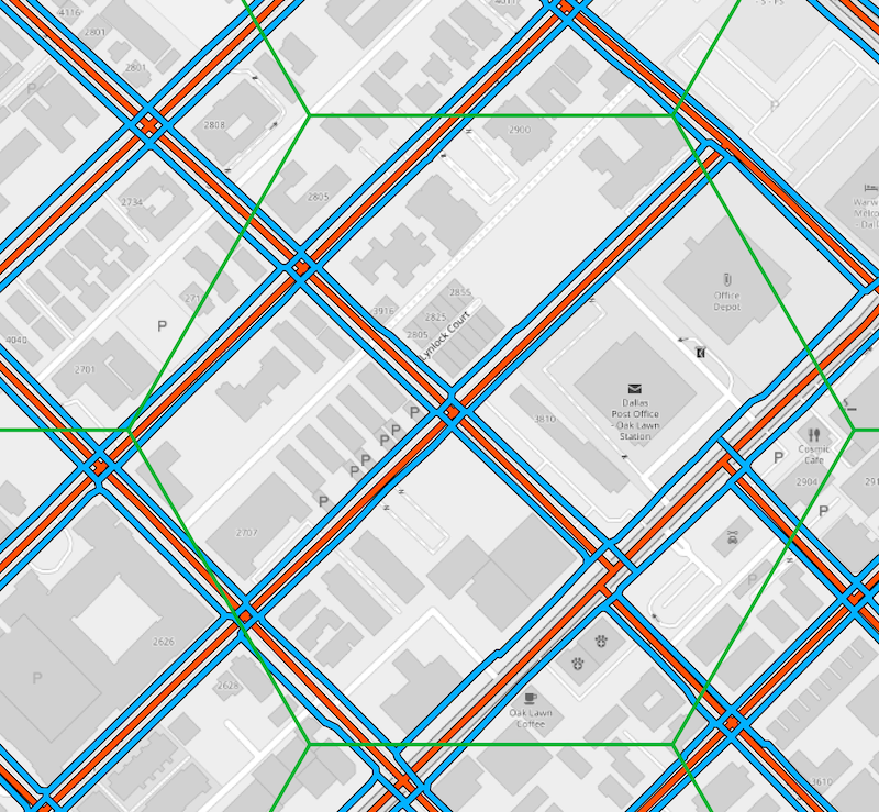
OSM Pedestrian Density Visualization [1] | © mvexel | map data © OpenStreetMap contributors
Breaking news
- The next OSMF Board meeting is on Thursday 25 at 13:00 UTC. The meeting will be held in the ‘Boardroom’ Big Blue Button video conference room. The Strategic Plan will be discussed. You can connect 20 minutes before the meeting.
Mapping
- [1] Martijn van Exel analysed the density of pedestrian infrastructure in the Boston and Dallas areas using visualisations of OpenStreetMap data.
- Steffen Voß explained
 ► how to use OSM tags (to model real-world attributes of buildings etc.) to set visual effects in streets.gl, a 3D-based map application.
 - Piet Brömmel has integrated website contribution statistics based on the first year of contribution into his OpenStreetMap Statistics. He noted that in 2022, just under 50% of all edits were made using accounts that submitted their first changeset between 2018 and 2022.
- Wilmer Osario, from Venezuela, wrote ► a forum post detailing how to add
placenodes to farms, based on aerial photography, some local knowledge, and reason.
 ►
►
 ►
►Community
- BudgieInWA wrote about how they and like-minded people mapped Hyde Park, in Northbridge, Perth, Australia, in detail and met new friends at the same time.
- Julien Minet compared ► the number of mapped addresses in OpenStreetMap with the number of addresses in the ICAR register for Wallonia, one of the three Belgian states.
- Rupert Allan (who some UK OSMers may remember from a project in South Wales) blogged about his invitation to consult on a new OSM project on mapping ancient wetlands in Jordan with a community of different ethnic groups.
 ►
►OpenStreetMap Foundation
- Steve Coast has suggested an alternative to the OSMF’s 2023 strategic plan. You can either discuss via the osmf-talk mailing list, on the community forum, or of course on twitter.
- At the start of the year, the OSMF Board put together their thoughts on what they saw ahead. Four months later, there is a lot to reflect on and assess – each board member presents their thoughts.
Events
- The OpenStreetMap Philippines Community will host the MAPAtalks Volume 1 workshop on 27 May 2023.
- You have less than a week and a half left to submit your application to host #StateoftheMap2024.
- The State of the Map Europe 2023 organising team is looking for helping hands. At present help with finding sponsors and establishing the programme committee are the most important. But help is welcome for other tasks too. If you haven’t done so already, mark your calendar for 10 to 12 November. Subscribe for updates at stateofthemap.eu.
- The preliminary agenda for the French SotM 2023 conference is now available .
Maps
- Andy Townsend has added OSM UK’s existing cadastral parcels layer to his map.atownsend.org.uk map.
Programming
- Four OpenStreetMap-themed projects have been selected for the 2023 Google Summer of Code.
- Ash Kyd explained how he used vector map technology to create a map of bike lanes in Brisbane, Australia.
- Andrii Holovin, a member of the Ukrainian OpenStreetMap community, proposed some exciting ideas for OSM 2.0. His suggestions include utilising Git as a version control system, storing objects in the YAML format, and introducing various additional features to enhance the functionality of the API.
Releases
- Peter explained the use of the ‘route hint’ and ‘custom model’ features of the GraphHopper application.
- The May 2023 version of Organic Maps has been released.
OSM in the media
- The online magazine BASIC thinking tested ► the bicycle navigation offered by OsmAnd.
- GadgeteerZA reviewed Magic Earth for car navigation on Android Auto.
Other “geo” things
- The geoEpi group attended the CGA 2023 ‘From Geospatial Research to Health Solutions’ at Harvard in Cambridge, Massachusetts. Along with others Sven Lautenbach, from HeiGIT, and PhD student Steffen Knoblauch, from GIScience, provided a general introduction into the field of GIS health applications.
- Ireland’s Environmentalists tweeted about EPAIreland’s Pollution Impact Potential (PIP) maps, which show the coverage of phosphorus pollution in Ireland due to high livestock activity and poorly draining soil. Excessive phosphorus pollution can result in excessive plant growth, algal blooms, and a reduction in the amount of oxygen in the water, which is not good for the aquatic species that live there.
Upcoming Events
| Where | What | Online | When | Country |
|---|---|---|---|---|
| Washington | OSM US Mappy Hour | ✓ | 2023-05-18 |  |
| UN Mappers – OSM and humanitarian mapping training – session #3 | 2023-05-18 | |||
| Toulouse | Réunion du groupe local de Toulouse | 2023-05-20 |  | |
| Bremen | Bremer Mappertreffen (Online) | ✓ | 2023-05-22 |  |
| San Jose | South Bay Map Night | ✓ | 2023-05-24 | |
| Bayonne | Cartopartie à Bayonne – 25 mai 2023 | 2023-05-25 | | |
| UN Mappers – OSM and humanitarian mapping training – session #4 | 2023-05-25 | |||
| 左營區 | 2023年5月 OpenStreetMap 街景踏查團 | 2023-05-27 |  | |
| Singapore | OG Training by HOTOSM AP-Hub | OSM ON THE GO: OSM MOBILE APPLICATIONS | 2023-05-27 | |
| OSMF Engineering Working Group meeting | 2023-05-31 | |||
| Düsseldorf | Düsseldorfer OpenStreetMap-Treffen | 2023-05-31 | | |
| Bologna | Alluvione dell’Emilia-Romagna: editathon e mapping party al Salaborsa Lab | 2023-06-03 |  |
Note:
If you like to see your event here, please put it into the OSM calendar. Only data which is there, will appear in weeklyOSM.
This weeklyOSM was produced by Elizabete, MatthiasMatthias, PierZen, SomeoneElse, Strubbl, TheSwavu, andygol, darkonus, derFred, rtnf, s8321414, 冰觞沐雨.
We welcome link suggestions for the next issue via this form and look forward to your contributions.