06/06/2023-12/06/2023
Sentiers balisés – pour la randonnée, le cyclisme, le VTT, l’équitation et plus encore. [1] © waymarked trails | données cartographiques © Contributeurs et contributrices OpenStreetMap
Cartographie
- Anne-Karoline Distel a publié un article sur les stations de recharge d’eau potable, un tutoriel vidéo sur la création d’un préréglage et l’ajout d’options de recharge dans les boutiques à l’aide d’OsmAnd.
- publicerination a importé les peintures murales de StreetSmArts à San Francisco.
- Le vote sur la proposition de dépréciation de
maxspeed:seasonal:winterest ouvert jusqu’au mardi 4 juillet.
Campagnes de cartographie
- L’équipe de Champs-Libres poursuit sa série sur la cartographie de l’accessibilité des gares avec un article sur la façon de cartographier l’accès aux quais de gare.
Communauté
- Le contributeur dreamy a résumé
 ► les similitudes et les différences entre
 emergency=assembly_pointqui est un lieu de rassemblement et aussi un abri temporaire,bunkerqui est un abri plus robuste, etamenity=shelterqui décrit un abri contre les intempéries. - DW Chung participera bientôt au Google Summer of Code de cette année. Leur projet, « liaisons OSRM Python », vise à créer une bibliothèque Python de recherche d’itinéraires basée sur l’Open Source Routing Machine (OSRM).
- JM-Lemmi a mis à jour tous les chemins de la forêt de Weinsberger Berge, en Allemagne, et a parcouru 515 km à vélo pour cela.
 ►
►
Événements
- Le site web d’OSMScience 2023 (dont nous vous avions déjà parlé) est désormais opérationnel. La date limite de soumission des résumés est fixée au mardi 1er août.
Cartes
- Chris Whong a construit une carte interactive qui vous montre, en utilisant les données GTFS de l’Autorité de transport métropolitain de New York et Turf.js, les isochrones de voyage à partir de la station de métro de New York que vous avez choisie sur un fond de carte OSM (via Lat × Long).
Développement
- Kshitijraj Sharma explore dans son Blog OSM les possibilités du modèle « Segment Anything Model (SAM) » développé par Meta pour la détection de caractéristiques sur l’imagerie et la cartographie éventuelle dans les éditeurs OSM.
- ZeLonewolf publie un guide sur la façon de faire fonctionner votre propre serveur de tuiles vectorielles OpenMapTiles sur Amazon Web Services (AWS) pour moins de 20 $ par mois.
Nouvelles versions
- La version de juin d’Organic Maps comprend l’ajout de l’import de GPX, des corrections pour les signets, des cartes mises à jour et la prise en charge des coordonnées MRGS et UTM.
Connaissez-vous ? …
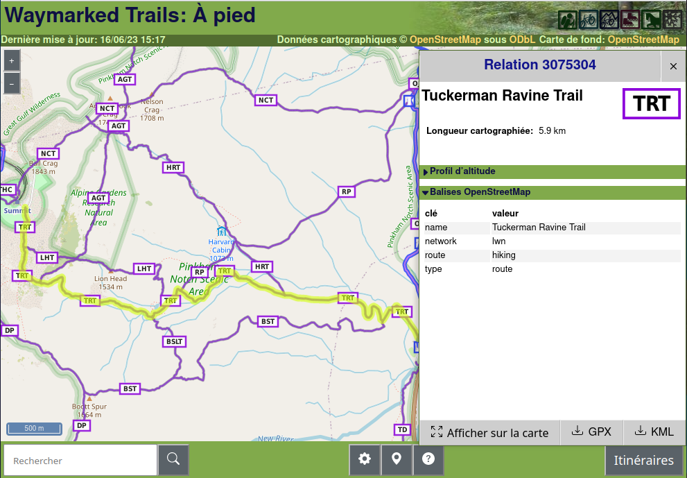
- [1] … la carte hiking.waymarkedtrails basée sur OSM ? Elle aide à faire le suivi des super-relations et relations d’itinéraires et offre une riche documentation sur les sentiers de randonnée, y compris le réseau, la référence, le niveau de difficulté (sac_scale), les balises de sentiers (osmc:symbol) et les profils d’élévation en utilisant les attributs OSM. La hiérarchie des superroutes et routes OSM permet d’illustrer les profils d’élévation et télécharger les sentiers à différents niveaux de détail (format kml et gpx). Il existe également d’autres sports couverts par waymarked trails.
Autres sujets géographiques
- Natalie Stechyson (CBC News) a évoqué le déclin des compétences en matière de lecture de cartes à l’ère du GPS. Bien que certains déplorent le déclin apparent des compétences en lecture de cartes, George Bevan a souligné qu’à bien des égards, les cartes sont plus intégrées dans notre vie quotidienne qu’elles ne l’ont jamais été, notant à quel point nous utilisons tous le GPS, la vue satellite et les cartes Google.
- Depuis 2007, des négociations ► sont en cours entre l’Allemagne et la Suisse pour conclure un nouveau traité qui redéfinira la frontière du Haut-Rhin comme étant la ligne médiane plutôt que le thalweg actuellement utilisé. En préparation, des géomètres ont délimité la nouvelle frontière, ce qui a eu pour effet de rapprocher la frontière de la Suisse de 8 mètres sur le pont couvert de Bad Säckingen.
- gontsa montre des images satellites spectrales Sentinel-2 de zones inondées après la destruction du barrage de la centrale hydroélectrique de Kakhovka.
 ►
►Événements à venir
| Où | Quoi | Online | Quand | Pays |
|---|---|---|---|---|
| Bari | FOSS4G-it 2023 | 2023-06-12 – 2023-06-17 |  | |
| Chippewa Township | Michigan Meetup | 2023-06-15 |  | |
| Salt Lake City | OSM Utah Monthly Map Night | 2023-06-15 | | |
| Eti Osa | Open Source for Good with Open Street Maps | 2023-06-15 – 2023-06-17 | ng | |
| UN Mappers – OSM and humanitarian mapping training – session #7 | 2023-06-15 | |||
| Köln | Missing Maps Mapathon meets Medex | 2023-06-15 |  | |
| Kaiserslautern | OSM Mapping Event Erfassung von Barrieren | 2023-06-17 | | |
| Anglet | Cartopartie à Anglet (64) | 2023-06-17 |  | |
| City Of Cockburn | Social Mapping Saturday: Port Coogee | 2023-06-17 |  | |
| Waterford City Metropolitan District | Using OpenStreetMap to record place names | 2023-06-17 |  | |
| Toulouse | Réunion du groupe local de Toulouse | 2023-06-17 | | |
| MapRoulette Nights | 2023-06-18 | |||
| Reunião – OSM Brasil – Mapeamento Aberto para Gestão de Riscos/Desastres [Horário 2] | 2023-06-19 | |||
| 삼성동 | 국경없는의사회 한국지부 Missing Maps 온라인 매파톤 | ✓ | 2023-06-20 |  |
| Gent | OpenStreetMap meetup in Gent | 2023-06-20 |  | |
| Lyon | Réunion du groupe local de Lyon | 2023-06-20 | | |
| San Jose | South Bay Map Night | ✓ | 2023-06-21 | |
| 164. Treffen des OSM-Stammtisches Bonn | 2023-06-20 | |||
| City of Edinburgh | OSM Edinburgh Social | 2023-06-20 |  | |
| The Municipal District of Kilkenny City | Kilkenny History Mappers 1st MeetUp | 2023-06-20 | | |
| Lüneburg | Lüneburger Mappertreffen (online) | 2023-06-20 | | |
| Karlsruhe | Stammtisch Karlsruhe | 2023-06-21 | | |
| Mainz | OpenStreetMap-Stammtisch Mainz | 2023-06-21 | | |
| UN Mappers – OSM and humanitarian mapping training – session #8 | 2023-06-22 | |||
| Hlavní město Praha | Missing Maps MSF CZ Mapathon at Logio | 2023-06-22 |  | |
| Localidad Teusaquillo | Junta Bimensual OSM LATAM – Junio | June | 2023-06-24 | |
| MapRoulette Nights | 2023-06-25 | |||
| Prizren | FOSS4G | 2023-06-26 – 2023-07-02 |  | |
| Bremen | Bremer Mappertreffen (Online) | ✓ | 2023-06-26 | |
| OSMF Engineering Working Group meeting | 2023-06-28 | |||
| UN Mappers – OSM and humanitarian mapping training – session #9 (final) | 2023-06-29 | |||
| Düsseldorf | Düsseldorfer OpenStreetMap-Treffen | 2023-06-30 | |
Note: Pour que votre événement apparaisse dans l’hebdoOSM, ajoutez-le au calendrier OSM.
Cet hebdoOSM a été préparé par MatthiasMatthias, PierZen, SeverinGeo, Strubbl, TheSwavu, derFred, renecha.