09/01/2024-17/01/2024
Mapping
- Requests for comments have been made on these proposals:
hitchhiking=trueto add a tagging system for hitchhiking spots, aiming to identify common and successful hitchhiking locations.toilets:menstrual_productsfor adding information about whether a toilet has menstrual products available or not.
Community
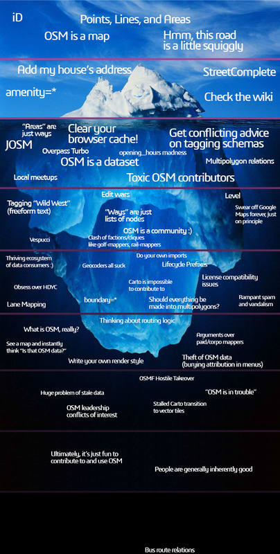
- [1] Xvtn has created an OpenStreetMap-themed iceberg chart meme.
- Anne-Karoline Distel described how she searched for and mapped village pounds in Ireland and Great Britain.
- Franjo Lukežić explained how to set up a drawing tablet to improve the FastDraw experience in JOSM. There is also a hint (towards the end) on how to reduce the amount of clicks when drawing a neighbouring area.
- King edgar blogged about his experience at the State of the Map Africa 2023 conference in Yaoundé, Cameroon. The event was focused on ‘Open Mapping as a Support Tool for Local Development in Africa’.
- Makilagi Ed shared their experience of mapping with OpenStreetMap for the first time, detailing how taking a journey through familiar and new areas, marking waypoints and creating routes, has deepened their understanding of the art of mapping.
- unsungNovelty published a post about three places on OpenStreetMap that he has mapped and remembered the most. He noted the beauty of Valparaiso in Tamil Nadu, told how he had to correct his mistakes in Pettineo, Italy and shared how he refined the contours of Dirks Lake in Arkansas, USA.
- Tom Hughes, maintainer of the OpenStreetMap website, made it to the OpenUK New Year’s Honours list, which recognises the UK’s top open source influencers.
- The OpenStreetMap France community is debating
 the future of their social media presence, particularly on Twitter and Mastodon, with discussions focusing on whether to continue using Twitter, fully migrate to Mastodon, or adopt a hybrid approach for broader outreach and engagement.
 the future of their social media presence, particularly on Twitter and Mastodon, with discussions focusing on whether to continue using Twitter, fully migrate to Mastodon, or adopt a hybrid approach for broader outreach and engagement.
OpenStreetMap Foundation
- The next OSMF Board meeting will be held via the Video room on Thursday 25 January, 13:30 UTC.
- Komoot is now an official Gold Corporate Member of the OpenStreetMap Foundation.
- Mateusz Konieczny, OpenStreetMap Foundation Board member, shared the procedure for reporting those OSM tile server users who do not provide proper attribution.
Local chapter news
- Amanda McCann triggered a discussion by reporting that Slack, a proprietary chat service used by the OSM US and others, is moving to an ‘ephemeral’ 90 day history of discussions unless using thee paid service. Alternatives to this service are being discussed.
- The next FOSSGIS OSM Community Meeting will be held ► in Essen, Germany in May 2024.
- OpenStreetMap US hosted a virtual conference event titled ‘Mapping USA 2024’, which ran on 19 and 20 January.
- OpenStreetMap US is selling various OpenStreetMap-themed merchandise.
 ►
►
Events
- The call for the SotM 2024 travel grant programme is now open. Apply before the end of January if you need financial support to join the State of the Map 2024 in Nairobi.
- An event to be held at the EPN – Médiathèque Louis Aragon in Martigues on Friday 22 March will offer ► an introduction to OpenStreetMap and how to contribute, as part of a series of collaborative workshops organised by the city’s public digital space to explore digital tools and practices suitable for different skill levels.
- KDE España released a recording of the talk titled ‘Geographic Open Data with OpenStreetMap’ via YouTube. You can also watch this video on the PeerTube instance maintained by the KDE community.
- HeiGIT reported that their ‘Waterproofing Data’ project, a mapping project to improve disaster mitigation process in the flood-prone areas of Brazil, has won the ESRC Celebrating Impact Prize 2023 in the ‘Outstanding Societal Impact’ category.
- Participants in the OpenStreetMap@Asia channel in Telegram held their second monthly workshop, tentatively called ‘Map-py Wednesday’, with the goal of encouraging regional mappers to get to know each other better, share about local happenings, and learn from each other, through snappy map-py (lightning) talks. Map-py Wednesday is held online on the third Wednesday of the month, at 08:30 UTC.
Education
- The UN Maps Learning Hub has launched its OSM Advanced courses, starting with a course on validating data in OSM. It offers an initial guide to learning validation techniques and tools such as the OSM Tasking Manager validation steps, JOSM tools and plugins, Overpass, Osmose, Whodidit, OSMCha, then a guide to learning how to interact with OSM contributors, and finally a guide that proposes a specific validation workflow for different map features (places, land use, road network, hydrography, bridges, fords and culverts) with a long-term perspective. Feedback is welcome!
OSM research
- A new building classification model using OpenStreetMap building data aims to estimate the earthquake risks to the built environment, enhancing the accuracy of damage assessment and aiding in disaster management.
- HeiGIT and Amsterdam University Medical Centres have conducted a study to analyse the relationship between the food-related retailers location data on OpenStreetMap and its influence on the health of people living in an area.
Maps
- Christoph Hormann released some additional layers for Musaicum EU-plus, a 10 m resolution satellite image mosaic of Europe.
- Paul Norman analysed the load and performance of the minutely map tile updates on OpenStreetMap. With an update capacity of 4800 tiles per second, the OSM server is expected to handle 95% of map tile update requests in less than 60 seconds.
- Russ Garrett tooted a map of the world’s electricity networks made using data from OpenStreetMap.
OSM in action
- Geocaching noted their OpenStreetMap-based Trails map as a replacement of Google Maps for their premium members. They highlight that the maps are made by locals, that they have more details and are offline available.
- Jake Coppinger released his ‘Australian Cycleway Stats’, a web dashboard that displays statistics on cycleways in Australia based on data from OpenStreetMap.
Open Data
- Sven Geggus has updated the list of trekking locations in Germany on the OpenStreetMap wiki ►. Some areas on this list still need more details.
Software
- Daniel Schep announced that he has made a new version of Overpass Ultra that makes it easier to customise map styles and feature popups.
- bs2000 has created ► an OpenStreetMap-based journey planner application. This application is able to process the GPX route of the planned journey, then it will find nearby travel-related POI locations (such as toilets, lodging, refuelling stations and others) along the route.
- Pieter Vander Vennet blogged about all the achievements of MapComplete in 2023. It is an impressive list!
- Vespucci tooted that support for OAuth2 is available in version 20, which is planned to enter the first beta stage at the end of March 2024.
Programming
- Mark Litwintschik has written about how to work with openly published flight tracking data collected by a network of volunteers contributing to a common aircraft tracking feed.
- Lucas Longour created some userscripts to display Panoramax links on OpenStreetMap and overpass turbo.
- rtnf has shared Javascript code to integrate OpenStreetMap data with Wikidata.
Releases
- GeoDesk for Python 0.1.4 has been released. Highlights include large-area spatial queries now being 4 to 30 times faster (find all 60+ million mapped buildings in the US in under a second), and area calculations for features near the poles are now significantly more accurate.
- Version 2.2.0 of Transportr has been released, with the main change being the switch to MapLibre, making it available on F-Droid again.
- Tilemaker version 3.0.0 has been released. It can convert OSM data in osm-pbf format into Mapbox Vector Tile format (.mbtiles).
Did you know …
- … there is an OpenStreetMap Notes HeatMap?
- … about the OpenCage Geothreads geography trivia collection?
- … that you can create OpenStreetMap-based map posters using the Map Poster Creator app?
- … that the URL osm.org redirects to OpenStreetMap?
- … about the Mastodon OpenStreetMap Diaries Bot account?
- … that the OpenStreetMap Foundation supports, but does not control, the OpenStreetMap project?
- … how to synchronise ► GPX track data from OsmAnd to a PC?
OSM in the media
- Mortiz Poldrack, from Tarnkappe.info, reported ► on the OpenStreetMap Foundation’s move to enforce the rules regarding OSM’s data attribution requirements.
Other “geo” things
- Using LiDAR technology, a team of archaeologists have discovered a cluster of ancient city traces in the Amazon rainforest region of Ecuador.
- Using training data from Google Street View, a team of students from Stanford University have built an AI system to automatically detect where photos were taken. In a ‘Geoguessr’ geolocation competition, this AI system successfully defeated a human geolocation expert in multiple rounds.
- Mapbox released MapGPT, a location-aware AI assistant.
- NASA has launched TEMPO (Tropospheric Emissions: Monitoring of POllution), a satellite-based air quality monitoring system. This satellite can provide hourly reports on atmospheric pollutants in the North American region.
Upcoming Events
| Where | What | Online | When | Country |
|---|---|---|---|---|
| Gent | OpenStreetMap meetup & MapComplete workshop at TomTom | 2024-01-18 |  | |
| Washington | Mapping USA | ✓ | 2024-01-19 – 2024-01-20 |  |
| Bengaluru | OSM Bengaluru Mapping Party | 2024-01-20 |  | |
| City of Fremantle | Social Mapping Saturday: Fremantle 2024 | 2024-01-20 |  | |
| Hai Buluk | OSM Africa Monthly Mapathon: Map South Sudan | ✓ | 2024-01-20 | ss |
| Windsor | OSM Windsor-Essex Meetup | 2024-01-23 |  | |
| Bremen | Bremer Mappertreffen | 2024-01-22 |  | |
| San Jose | South Bay Map Night | ✓ | 2024-01-24 | |
| iD Community Chat | 2024-01-24 | |||
| OSMF Engineering Working Group meeting | 2024-01-24 | |||
| London Borough of Islington | Geomob London | 2024-01-24 |  | |
| Richmond | MapRVA Happy Hour | 2024-01-25 | | |
| [Online] OpenStreetMap Foundation board of Directors – public videomeeting | 2024-01-25 | |||
| Lübeck | 138. OSM-Stammtisch für Lübeck und Umgebung | 2024-01-25 | | |
| Wien | 70. Wiener OSM-Stammtisch | 2024-01-25 |  | |
| MapComplete Community Call 2024-01 | 2024-01-26 | |||
| Terni | Compleanno OpenStreetMap Italia 2024 | 2024-01-26 |  | |
| Localidad Teusaquillo | Mapeemos los restaurantes de la calle Bonita y la Macarena | 2024-01-27 |  | |
| Saint-Étienne | Rencontre Saint-Étienne et sud Loire | 2024-01-30 |  | |
| Salt Lake City | Salt Lake City Monthly Map Night | 2024-02-01 | | |
| Düsseldorf | Düsseldorfer OpenStreetMap-Treffen (online) | 2024-01-31 | | |
| Amsterdam | End of Winter Mapping Party | 2024-02-01 |  |
Note:
If you like to see your event here, please put it into the OSM calendar. Only data which is there, will appear in weeklyOSM.
This weeklyOSM was produced by MatthiasMatthias, PierZen, Strubbl, TheSwavu, barefootstache, derFred, mcliquid, rtnf.
We welcome link suggestions for the next issue via this form and look forward to your contributions.
The language switcher links for Weeklyosm should be located at the top, not down at the bottom. Try reading this on a cell phone and you’ll see.
Or put them under one button there on the top that when pressed expands to the many language links. Perhaps have an icon, a globe, for it.
Agree. Why do I have to scroll to the bottom just for this. A menu below the (useless) banner is not uncommon for things like the language switcher, the Search box, the RSS Feed.
The Contribute link should also be at the top, or in a menu, to make it prominent.
Hello, my mom has set my cell phone so that all websites are automatically translated into my language. I don’t have to press anything.
Well I prefer non-machine translated content. So am happy to push a national flag button.
The problem is as you can imagine, wading through line after line of words that one does not understand, looking for the flags that are hidden way down at the bottom.
We have put your good idea into our backlog. Thank you very much.