18/09/2025-24/09/2025
[1] OpenPoiMap 2025 | Map data © OpenStreetMap contributors.
About us
- The OpenStreetMap (OSM) ecosystem is very vast, making it complicated to investigate user preferences for OSM-related software or topics. A Keynote will be presented by Raquel Dezidério Souto at the State of the Map 2025, in English, showing the development of a study on the publication profile of the weeklyOSM, analyzing the content of the issues published on the last ten years (numbers 272 to 768), since it began to be organized with the OpenStreetMap Blog Collector (OSMBC), created by TheFive. The self-organized session is scheduled to Saturday, October 4th, 2025, 10:30 – Manila Time (UTC+8). This research was previously noticed by us in the numbers #783 and #769.
Community
- Responding to recent province-wide restructuring of New Brunswick’s (Canada) municipal boundaries, user 022 began an OpenStreetMap import project to update the boundaries across the province.
- Gregory Peony explained how to download OSM data within a geometry via Overpass and JOSM.
- In the latest OpenCage interview series, Ed interviewed Dustin Carlino about his recently launched business, A/B Street, a consultancy that develops open-source transportation planning tools.
- Kenny has mapped several islands off the west coast of the Korean Peninsula.
- How many pavements have been mapped in Germany so far? User Kumakyoo attempted to answer this question, and explains the surprisingly small amount with missing feedback for mappers.
- The Open Security Mapping Project aims to improve the visibility of security institutions and infrastructure in the United States in several open-data projects, such as OpenStreetMap, Wikidata, Wikipedia, and Wikimedia Commons.
- Rubén and Minh shared their impressions of the Latin American OSM community after representing OpenHistoricalMap at State of the Map Latam in Medellín.
OpenStreetMap Foundation
- Pablo Brasero Moreno has joined the OSMF as Core Software Engineer, bringing his open-source experience from Belfast to support the technical development of the OSM website and ease the workload of the volunteer community.
- The OpenStreetMap.org website and its mapping API will be read-only for server maintenance on Sunday 5 October between 09:00 and 12:00 UTC. During this shutdown the OpenStreetMap Ops Team plans to upgrade the database to PostgreSQL 17, update the server firmware, and switch the weekly internal PostgreSQL database backups to ZSTD compression to speed up the generation of weekly planet dumps.
Events
- Unique Mappers Network announced that State of the Map Nigeria will be held from Tuesday 28 October through Thursday 30 October, at the University of Nigeria, Enugu campus.
- The next Geomob Edinburgh, #geomobEDI, will be held at 18:30 (doors open at 18:00) on Tuesday 30 September at the office of Esri UK Floor 2, Quartermile Three, 10 Nightingale Way, EH3 9EG Edinburgh.
- The SotM Nigeria 2025 LoC has published their sponsorship prospectus for the State of the Map Nigeria 2025.
- Besides the main programme of the SotM 2025, the organisers are offering a space for self-organised sessions (in person or remotely), for discussions about topics that are suitable for small groups. The topics need to be related to OpenStreetMap. For on-site self-organised sessions, they will set up a white board at the conference venue to reserve a time slot and room. The only requirements are that the participants have a conference ticket (can be also ‘venueless ticket’) which grants them access to the event’s platform, and that they abide by the conference’s Code of Conduct. You can register your self-organised session directly in the OSM wiki.
- Over 50 sessions have already been announced for State of the Map Europe 2025, taking place on Friday 14 November and Saturday 15 November at Abertay University in Dundee, Scotland, including talks, workshops, panels, and discussion groups.
Education
- Raquel Dezidério Souto blogged about the bilingual (PT|EN) tutorial she has written about mapping ways in OpenStreetMap. It was prepared for the workshop that was promoted 100% online and open to everyone. Raquel included important observations resulting from her three years of experience teaching OSM, many of which are not found in previously published manuals.
Maps
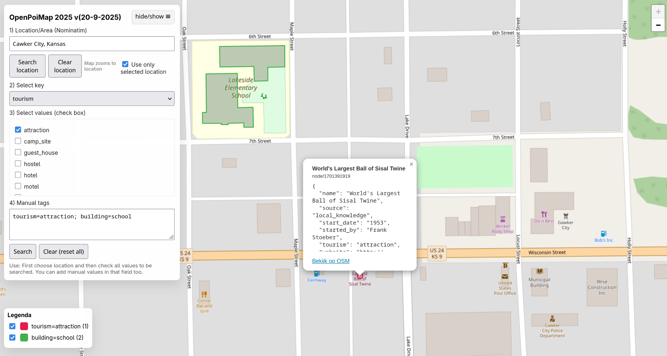
- [1] OpenPoiMap 2025 is a revamped version of the popular tool (we reported earlier) that allows searching for any OpenStreetMap tags at any location. This tool was developed
 by Marc Zoutendijk as a user-friendly alternative to overpass turbo.
 - Javier Yanzón wrote ► on LinkedIn about his prototype tool that calculates travel times and driving distances between multiple geographic points using the OpenRouteService API.
 by Marc Zoutendijk as a user-friendly alternative to overpass turbo.
 ►
►
OSM in action
- The NREL now relies on OpenStreetMap substation data for US datacentre planning. Anyone interested in contributing to this dataset can do so via MapYourGrid.org.
- Formula One teams are using AccuWeather, along with its OpenStreetMap-derived PMTiles base layer, for radar imagery.
Open Data
- OpenStation provides open data (CC0) on passenger station infrastructure in Germany.
- Xiao Xiang Zhu et al. have developed GlobalBuildingAtlas, a publicly available dataset (CC BY-NC 4.0 license) that provides global coverage of building polygons, heights, and Level of Detail 1 3D building models. To create this dataset, they combined satellite data with building footprint datasets from various sources, including OpenStreetMap, Google Open Buildings, Microsoft Building Footprints, and the Comprehensive Large-Scale Mapping Building Footprints dataset.
Software
- Bike Streets blog has published ‘bks_engineering: From Paper Maps to Digital Routing Engine’, a blog post about the process used to generate turn-by-turn directions in the Bike Streets app (available on Android and iOS). This service is not available for all countries.
- Wolfmond tooted that Oldenburg Helirescue, a new open-source game, is in development. In the game you can fly a helicopter over Oldenburg, Germany, and complete randomly selected rescue missions, all built using OpenStreetMap and Leaflet.
- Pi Square has built ‘OSM Mapper Streak‘, a tool to track your OpenStreetMap editing streaks.
Releases
- Together with the German Federal Agency for Cartography and Geodesy, HeiGIT has released a new version of their ohsome dashboard, introducing a new indicator for assessing the thematic accuracy of land cover data in OpenStreetMap.
Did you know that …
- … the base maps on the monitors in Deutsche Bahn’s ICE trains come from Maps for Europe? This is a joint project between EuroGeographics and the EU that makes official topographic data from across Europe publicly available.
- … GNU/Linux.ch explained ► how to easily share a location or map section using OsmAnd via a link that opens in any browser, complete with coordinates and zoom level, without requiring the app.
 ►
►Other “geo” things
- Yann Justeau presented ► a 3D model with free software, MapLibre GL, Geoserver and Martin, and following the OGC standards. He highlighted that it is not necessary to use proprietary software to elaborate a wonderful 3D scene! He has invited you to explore the EoGIS beta version.
- Emily demonstrated how to uncover the exact capture date of Street View panoramas despite Google only displaying the month, by exploiting an undocumented API endpoint and narrowing down the date using binary search.
- After testing notifications on a small number of datasets, the United Nations Office for the Coordination of Humanitarian Affairs (OCHA) Services has expanded coverage to the majority of data on their HDX platform (humanitarian data). Notifications are available for changes to individual datasets and for new data related to specific organisations, locations, or crises.
- Palestinians in the West Bank have built their own navigation apps including Azmeh and Doroob, to safely navigate increasing roadblocks, checkpoints, and GPS disruptions, often relying on OpenStreetMap and private WhatsApp groups for real-time updates.
 ►
►Upcoming Events
| Country | Where | Venue | What | When |
|---|---|---|---|---|
 | Virtual | Mapatón Nacional de México 2025 | 2025-08-19 – 2025-09-30 | |
 | Universidad Nacional de Luján | Encuentro de la Comunidad de OpenStreetMap de Argentina | 2025-09-27 – 2025-09-28 | |
 | Metz | L’Arob@ase | Atelier du groupe local de Metz – Septembre 2025 | 2025-09-27 |
 | TAK Kadıköy | OpenStreetMap Community Meet-Up – Istanbul | 2025-09-27 | |
| Intro to OpenStreetMap.org Operations – Getting involved | 2025-09-27 | |||
 | Gurgaon | DLF Phase 1 Metro Station | 23rd OSM Delhi MapWalk | 2025-09-28 |
| Saint-Étienne | Zoomacom | Rencontre Saint-Étienne et sud Loire | 2025-09-29 |
 | Helsinki | Antikvariaatti Sofia | OSM Suomi kartoittajatapaaminen | 2025-09-30 |
 | Stuttgart | Stuttgart | Stuttgarter OpenStreetMap-Treffen | 2025-10-01 |
| Thiruvananthapuram | Kowdiar Park, near Kowdiar Palace | Tree Map at Trivandrum | 2025-10-02 |
 | Madrid | Online | Mappy Hour OSM España | 2025-10-02 |
| Bochum | Das Labor, Alleestraße 50, Bochum | OSM-Treffen in Bochum | 2025-10-02 |
 | virtual | [Online] Oficina de mapeamento de áreas no OpenStreetMap com editor JOSM | 2025-10-02 | |
 | Quezon City | University of the Philippines Diliman | State of the Map 2025 | 2025-10-03 – 2025-10-05 |
| OSMF Engineering Working Group meeting | 2025-10-03 | |||
 | Rapperswil-Jona | OST Campus Rapperswil | 17. Mapathon & Mapping Party Rapperswil 2025 | 2025-10-03 |
 | Amsterdam | TomTom HQ | Maptime Amsterdam: Autumn mapping party | 2025-10-03 |
| नई दिल्ली | Jitsi Meet (online) | OSM India Online (Remote) Mapping Party | 2025-10-05 |
 | Salzburg | Bewohnerservice Elisabeth-Vorstadt | Vortrag – Wie nutze ich OpenStreetMap – BWS Lehen-Vorstadt, Salzburg | 2025-10-07 |
 | Derby | The Brunswick, Railway Terrace, Derby | East Midlands pub meet-up | 2025-10-07 |
| Missing Maps London: (Online) Mapathon [eng] | 2025-10-07 | |||
| Madrid | Online | Mappy Hour OSM España | 2025-10-09 |
| virtual | [Online] Oficina de validação com editor JOSM | 2025-10-09 | |
| Bochum | Das Labor, Alleestraße 50, Bochum | OSM-Treffen in Bochum | 2025-10-09 |
| Homburg | Mapathon Bliesgau, Saarpfalz-Kreis | 2025-10-09 | |
 | Online | OpenStreetMap Midwest Meetup | 2025-10-10 | |
| Berlin | TBA | 208. OSM-Stammtisch Berlin-Brandenburg | 2025-10-10 |
 | Castell’Arquato | Wikigita geologica Su e giù per l’antico Mare Padano | 2025-10-11 | |
| Berlin | Wikimedia e.V. Tempelhofer Ufer 23-24,10963 Berlin | OSM Hackweekend Berlin-Brandenburg 10/2025 | 2025-10-11 – 2025-10-12 |
 | Etalle | Cartopartie cyclable | 2025-10-11 | |
 | København | Cafe Mellemrummet | OSMmapperCPH | 2025-10-12 |
| Delhi | Outer West Delhi (exact venue to be decided) | 24th OSM Delhi MapWalk (Outer West zone) | 2025-10-12 |
| Missing Maps : Mapathon en ligne – CartONG [fr] | 2025-10-13 | |||
| Grenoble | La Turbine | Atelier découverte et initiation | 2025-10-13 |
 | 臺北市 | MozSpace Taipei | OpenStreetMap x Wikidata Taipei #81 | 2025-10-13 |
Note:
If you like to see your event here, please put it into the OSM calendar. Only data which is there, will appear in weeklyOSM.
This weeklyOSM was produced by MarcoR, MatthiasMatthias, Raquel Dezidério Souto, Strubbl, Andrew Davidson, barefootstache, mcliquid.
We welcome link suggestions for the next issue via this form and look forward to your contributions.