08/01/2019-14/01/2019
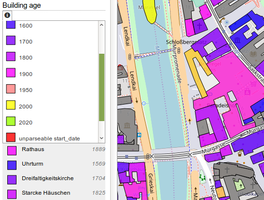
Age of buildings in the city centre of Graz, Austria 1 | © blog.openstreetbrowser.org © Map data OpenStreetMap contributors
Mapping
- The tagging mailing list has been very busy recently. The voting for four proposals has been started.
- The key
crossing:island=*is intended to indicate the existence of a pedestrian island at a road crossing. - The keys
prepaid_top_up=*,prepaid_top_up:brand=*andprepaid_top_up:network=*can help in finding a location where you can buy a top-up card for your phone. - If you want to specify whether a power line is insulated, you might be interested in the optional key
insulated=yes/no. - If there is a railway on a highway and this space is shared with vehicles, the new tag
embedded_rails=will allow you to tag the highway, although the rails are mapped as separate ways.
- The key
- One question that is regularly asked is the difference between
waterway=ditchandwaterway=drain. Eugene Podshivalov asked this question on the tagging mailing list and it became apparent that there is not yet consensus on the differences. - The city of Cologne, Germany, released
 (automatic translation) its recent aerial images under a CC0 license and offers WMS services that can be used with OSM editors.
 - Konrad Lischka shows how to query for selected information from OpenStreetMap with the Overpass API and how to visualise it with uMap using churches and church service times as examples (automatic translation).
- Christoph Hormann continues his ironic recommendations on how to map for the renderer, specifically how to render arbitrary text.
 (automatic
 Community
- Ben Abelshausen is advertising for Open Belgium 2019, a conference that will take place on March 4th in Brussels. In his mail he invites everyone to submit a talk and announces the availability of early bird tickets. He is also promising to organise a community day later this year.
- Martin Noblecourt mentions job offerings from CartONG on the talk-fr mailing list. The French NGO is looking for a trainee, a Missing Maps animator and more.
- Martijn van Exel announced the release of a new MapRoulette version. Version 3.1.2 is now available in Japanese too. It allows you to share filtered result lists with others and to edit just the current object in JOSM in areas with a lot of data unrelated to the task at hand.
- The Centre de Cultura Contemporània de Barcelona (CCCB Lab) features an article from Carlos Bajo where he explains how OpenStreetMap contributes to societal development in places where the government fails to provide basic services. He highlights the growing number of local contributions in Africa and the benefits of Open Data and OSM in particular.
- A discussion in the German forum (translation) asks whether Mapbox are “taking over tagging sovereignty in OSM”.
OpenStreetMap Foundation
- Guillaume Rischard announced that the new Organised Editing Guidelines have come into effect. The guidelines cover “edits that involve more than one person and can be grouped under one or more sizeable, substantial, coordinated editing initiatives.”
- derFred points to the possibility of becoming a member of the OSMF without the regular membership fee of 15 GBP if you cannot afford membership due to economic reasons. If you are an active mapper you can apply for the Fee Waiver Program. You can also apply if there is no payment option for the membership fee available for you (automatic translation).
Events
- SotM Africa 2019 in Côte d’Ivoire opened a Logo Contest.
Humanitarian OSM
- Pete Masters thanks HOT Tanzania for helping a hospital in Tanzania to implement a patient origin tracking system by mapping the surroundings and training of the hospital staff. The system is intended to help the hospital locate the source of a disease and it is hoped that it might help to prevent the spreading of diseases and infections too, according to the website ippmedia.com’s reports.
- Janet Chapman posted a review of 2018 for Crowd2Map, an initiative aiming to map Tanzania, in her user diary. She mentions the invitation to organise a mapathon at the UN, the award the organisation received at the last State of the Map in Milan and some of the talks she held during the year. Further information can be found on Crowd2Map’s website.
Education
- The new curriculum (pdf) for French high schools states that all students should be introduced to geospatial data usage. One of the expected abilities in that domain is the ability to “contribute to OpenStreetMap in a collaborative way”.
Maps
- [1] The website openstreetbrowser.org received an update that makes more detailed filtering for buildings available and now includes filters by building attributes such as type, age or height. The new map version also introduced office tags in thematic maps and provides more detailed popups in the Culture categories.
switch2OSM
- A short tweet about an event in the headquarters of the Ordnance Survey, the national British mapping agency, about “Road Flows” led Richard Fairhurst to ask for more details. The event was about using OpenStreetMap for improving data quality. In addition, the answer revealed that the Ordnance Survey searches for road direction mismatches between their own and OSM data and then sends surveyors to verify if required.
Software
- Many software projects use the fork and pull model approach for contributions. alexkemp explained the basics of this model in his OSM user diary after he faced this requirement for the first time when he wanted to update a Github-hosted project.
- Mapillary has just released a desktop application for uploading large amounts of street-level imagery, which can then be used for editing OpenStreetMap. It is currently available for Mac and Windows. Learn more on the Mapillary blog.
- Adam Rousell from the Heidelberg Institute for Geoinformation Technology reports that the latest version 4.7.2. of openrouteservice also includes information about access restrictions when your route takes you over roads that are marked in OSM as restricted (e.g. destination only roads, private roads etc.).
Programming
- Karry explains how he wrote his own hillshade tile server for his project OSM Scout for Sailfish OS, a project to bring offline OSM maps to Sailfish OS, after the previously used hillshade tiles from Heidelberg university stopped working.
- Reddit user nanothrowaway airs a lot of grouses about OsmAnd’s OSM Map Creator. Various redditors tried to explain why the data is kept in memory for efficiency reasons, but the OP maintained that it’s the use of Java which is the problem.
Releases
- MyOSMatic, a MapOSMatic instance at osm-baustelle.de, has upgraded the front end from Bootstrap v3 to v4.
Did you know …
- … you can use Traveltime Platform to create isochrones in several countries? One can create travel time polygons on a map, for example, “how far can I reach within 30 minutes by car/bicycle/public transport from my current location?”
- … the always up-to-date OSM Software Watchlist?
- … outdooractive.com with OpenStreetMap maps?
OSM in the media
- The German weekly newspaper Die Zeit uses OSM data to visualise the distribution of various sports (from cricket to football) worldwide (automatic translation).
Other “geo” things
- Matt Caywood, of Washington(DC)-based firm TransitScreen, announced the launch of OpenMobilityData – “the OpenStreetMap of transit” – a joint venture with non-profit MobilityData. The goal is an open data platform for transit and mobility data. The data have been seeded from TransitFeeds, which has been acquired by the new venture.
- The Hindu, the second most circulated English-language newspaper in India, published an article about OSM, the OSM community in India and the use of OSM in the humanitarian sector.
- The BBC World Service’s Business Daily programme aired an episode (select the download link on that page) devoted to the poor availability of modern up-to-date maps across Africa. This is the third episode titled “Africa’s Missing Maps” and mainly features businesses such as TomTom and the Ordnance Survey.
- Maxor Technologies, DigitalGlobe’s parent company, announced that the WorldView-4 Earth observation satellite has suffered a defect in its attitude correction system. Due to this loss of a stability axis, the satellite can no longer be used for image acquisition. WorldView-4 was launched in November 2016, making it the youngest satellite in the DigitalGlobe fleet. SpaceflightNow reports that the planned lifetime was 10 to 12 years.
- The British Guardian: “Off the chart: the big comeback of paper maps“.
- Aaron Straup Cope writes about how the term “airport gates” has multiple meanings (for passengers, airlines, aviation authorities) and how this affects where they should be placed on maps of airports.
Upcoming Events
| Where | What | When | Country |
|---|---|---|---|
| Ivrea | Incontro mensile | 2019-01-19 |  |
| Reutti | Stammtisch Ulmer Alb | 2019-01-22 |  |
| Nottingham | Nottingham | 2019-01-22 |  |
| Cologne | Köln Stammtisch | 2019-01-23 | |
| Lübeck | Lübecker Mappertreffen | 2019-01-24 | |
| Mannheim | Mannheimer Mapathons e.V. | 2019-01-24 | |
| Greater Vancouver area | Metrotown mappy Hour | 2019-01-25 |  |
| Bremen | Bremer Mappertreffen | 2019-01-28 | |
| Viersen | OSM Stammtisch Viersen | 2019-01-29 | |
| Arlon | Réunion au Pays d’Arlon | 2019-02-04 |  |
| London | Missing Maps Monthly Mapathon London | 2019-02-05 |  |
| Toulouse | Rencontre mensuelle | 2019-02-06 |  |
| Stuttgart | Stuttgarter Stammtisch | 2019-02-06 | |
| Helsinki | Missing Maps Mapathon at Finnish Red Cross HQ – Feb 2019 | 2019-02-07 |  |
| Dresden | Stammtisch Dresden | 2019-02-07 | |
| Berlin | 128. Berlin-Brandenburg Stammtisch | 2019-02-08 | |
| Dresden | FOSSGIS 2019 | 2019-03-13-2019-03-16 | |
| Portmarnock | Erasmus+ EuYoutH_OSM Meeting | 2019-03-25-2019-03-29 |  |
| Montpellier | State of the Map France 2019 | 2019-06-14-2019-06-16 | |
| Angra do Heroísmo | Erasmus+ EuYoutH_OSM Meeting | 2019-06-24-2019-06-29 |  |
| Heidelberg | Erasmus+ EuYoutH_OSM Meeting | 2019-09-18-2019-09-23 | |
| Heidelberg | HOT Summit 2019 | 2019-09-19-2019-09-20 | |
| Heidelberg | State of the Map 2019 (international conference) | 2019-09-21-2019-09-23 | |
| Grand-Bassam | State of the Map Africa 2019 | 2019-11-22-2019-11-24 |  |
Note: If you like to see your event here, please put it into the calendar. Only data which is there, will appear in weeklyOSM. Please check your event in our public calendar preview and correct it, where appropriate.
This weeklyOSM was produced by Polyglot, Rogehm, SK53, SomeoneElse, SunCobalt, TheSwavu, derFred, jcoupey, keithonearth.
Content de lire les hébdos. Un grand merci à chacun de vous pour votre contribution.